


Faribault, Minnesota
Faribault is a city of 24,631 people in Rice County, Minnesota, founded in 1855.
Why visit Faribault
Townapedia lists 14 museums and landmarks, 46 parks and trails, 27 places to eat, 8 places to stay and 2 attractions in and around town.
Highlights include Faribault Viaduct, Paradise Center for the Arts, Alexander Faribault House and Thomas Scott Buckham Memorial Library.
July is the warmest month, with average highs of 82°F; January lows average 5°F, and about 43 inches of snow fall in a normal year.
Weather in Faribault
Forecast from the National Weather Service. Full forecast
About Faribault
Faribault is a city in and the county seat of Rice County, Minnesota, United States. The population was 24,453 at the 2020 census. Faribault is about 50 miles (80 km) south of Minneapolis–Saint Paul.
From the Wikipedia article Faribault, Minnesota (this version), under CC BY-SA 4.0.
Things to do2

Faribault Viaduct
Bridge · National Register of Historic Places · 0.9 mi

Paradise Center for the Arts
Cinema and theater · 0.6 mi
Theater and movie theater in Faribault, Minnesota, United States
Museums and landmarks14

Alexander Faribault House
Monument and historic site · National Register of Historic Places · 0.9 mi
Historic house in Faribault, Minnesota, United States
12 1st Avenue Northeast
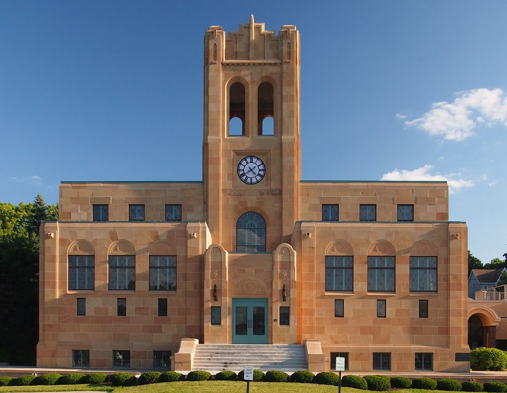
Thomas Scott Buckham Memorial Library
Monument and historic site · National Register of Historic Places · 0.9 mi
Library in Faribault, Minnesota, United States
11 Division Street East

Batchelder's Block
Monument and historic site · National Register of Historic Places · 0.7 mi
Building in Faribault, United States of America

Blind Department Building and Dow Hall, State School for the Blind
Monument and historic site · National Register of Historic Places · 1.3 mi
Building in Faribault, Minnesota, United States

Faribault City Hall
Monument and historic site · National Register of Historic Places · 0.7 mi
208 1st Avenue NW
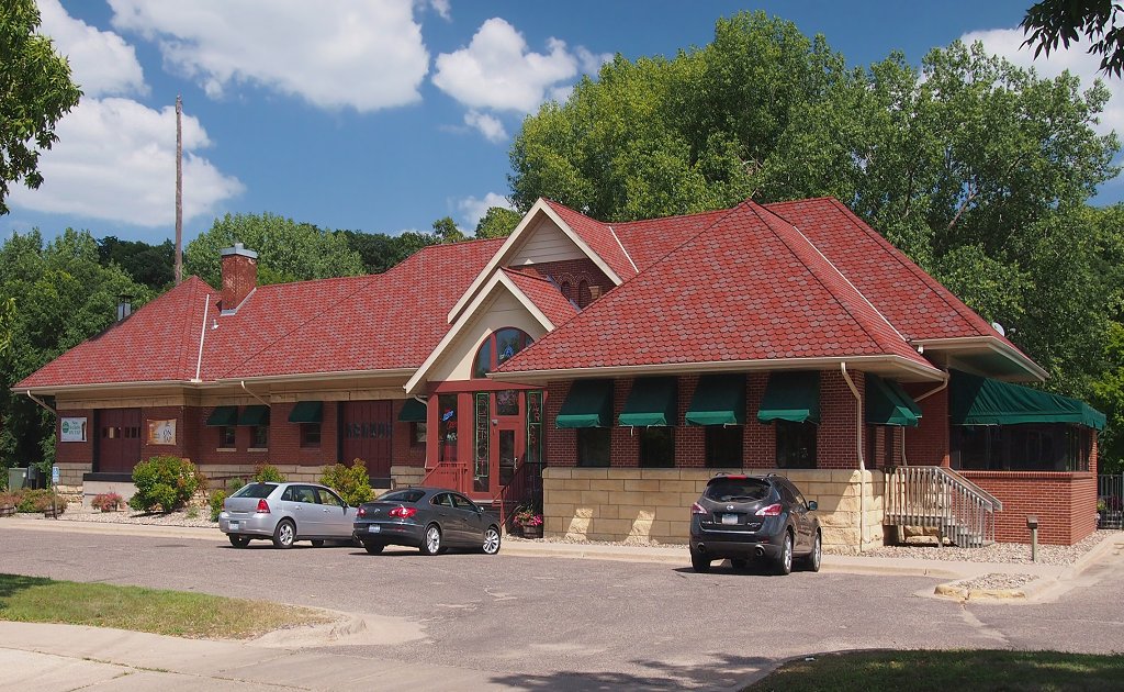
Faribault station
Monument and historic site · National Register of Historic Places · 0.7 mi
Historic railroad depot in Minnesota, U.S

Rice County Courthouse and Jail
Monument and historic site · National Register of Historic Places · 0.5 mi
Faribault, Minnesota, also NRHP-listed

Shattuck-Saint Mary's School
Monument and historic site · National Register of Historic Places · 0.9 mi
Private secondary school in Faribault, Minnesota


Thomas and Bridget Shanahan McMahon House
Monument and historic site · National Register of Historic Places · 1.2 mi
Faribault, Minnesota, NRHP-listed
Timothy J. McCarthy Building
Monument and historic site · National Register of Historic Places · 0.6 mi
Listed on the NRHP in Faribault, Minnesota
Faribault Woolen Mills
Monument and historic site · National Register of Historic Places · 0.4 mi

2 more on the map.
Parks, trails and playgrounds46




34 more on the map.
Restaurants and cafes27

Mizuki Fusion
Restaurant · Japanese · 0.5 mi
609 4th Street Northwest
Tu-Th 11:00-22:00; Fr-Sa 11:00-22:30; Su 12:00-21:30
Faribault Family Restaurant
Restaurant · Diner · 1.4 mi
Mo-Th 07:00-15:00; Fr 07:00-20:00; Sa-Su 07:00-15:00
Godfather's Pizza
Restaurant · Pizza · 0.4 mi
328 4th Street Northwest
Su-Th 11:00-21:30; Fr-Sa 11:00-22:30

Gran Plaza Mexican Grill
Restaurant · Mexican · 0.5 mi
520 Central Avenue North

The Depot Bar & Grill
Diner · American · 0.7 mi
311 Heritage Place
15 more on the map.
History
Faribault is regarded as one of Minnesota's most historic communities, with settlement and commercial activity predating Minnesota's establishment as a U.S. Territory. Until 1745, the area was primarily occupied by the Wahpekute band of Dakotah. Shortly thereafter, the tribe was driven south after several clashes with the Ojibwe over territory.
The city's namesake, Alexander Faribault, was the son of Jean-Baptiste Faribault, a French-Canadian fur trader, and Elizabeth Pelagie Kinzie Haines, a Dakotah woman. He is credited with fueling most of the early settlement in the area, beginning in 1826, when he established a fur trading post on the banks of the Cannon River. By 1834, the trading post had grown in popularity and was moved to the Straight River, one mile (1.6 km) upstream of its junction with the Cannon River, the site of modern-day Faribault. The young Alexander Faribault used his knowledge of Dakota language and culture to improve relations with the displaced Wahpekute and even helped the tribe resettle in the area. This relationship was instrumental in ensuring the trading post's success and allowing safe travel to the area for settlers. The Dakota in the area called this soon-to-be town "Adek" for Alex (Alexander Faribault).
Another source maintains the city is named for Jean-Baptiste Faribault.
From the History section of Faribault, Minnesota on Wikipedia, under CC BY-SA 4.0.
Where to stay8
Boarders Inn & Suites by Cobblestone Hotels - Faribault
Motel and hotel · 1.3 mi
1801 Lavender Drive, Faribault
GrandStay Residential Suites Hotel Faribault
Motel and hotel · 1.1 mi
1500 20th Street Northwest
Churches and places of worship15
Cathedral of Our Merciful Saviour
Church · Episcopal · National Register of Historic Places · 0.4 mi
515 2nd Avenue Northwest
Congregational Church of Faribault
Church · National Register of Historic Places · 0.6 mi
Fourth Avenue United Methodist Church
Church · Methodist · 0.6 mi
219 4th Avenue NW
The Church of Jesus Christ of Latter-day Saints
Church · Mormon · 2.2 mi
902 17th Street Southwest
Shopping4
Gas and EV charging9
Schools, colleges and libraries28
Healthcare2
Map of Faribault
155 places. The map loads OpenStreetMap tiles when you open it.
Climate by month
Monthly table
| Month | High | Low | Rain | Snow |
|---|---|---|---|---|
| Jan | 23°F | 5°F | 1.0 in | 9.4 in |
| Feb | 28°F | 8°F | 1.0 in | 10.6 in |
| Mar | 40°F | 20°F | 1.9 in | 6.4 in |
| Apr | 56°F | 33°F | 3.1 in | 1.6 in |
| May | 68°F | 45°F | 4.4 in | 0.2 in |
| Jun | 78°F | 57°F | 5.6 in | 0.0 in |
| Jul | 82°F | 61°F | 4.6 in | 0.0 in |
| Aug | 80°F | 58°F | 4.7 in | 0.0 in |
| Sep | 73°F | 50°F | 3.7 in | 0.0 in |
| Oct | 59°F | 36°F | 2.6 in | 0.1 in |
| Nov | 42°F | 24°F | 1.7 in | 4.9 in |
| Dec | 29°F | 13°F | 1.2 in | 10.1 in |
U.S. Climate Normals 1991-2020 for Faribault (1 mi away), NOAA NCEI.
People and cost of living
American Community Survey 5-year estimates, 2020-2024, U.S. Census Bureau. Estimates have margins of error, larger for small towns.
Disaster history
Rice County has had 9 federal disaster declarations since 2000, most often for floods.
- 2024-06-28: Severe Storms And Flooding (Flood)
- 2020-04-07: Covid-19 Pandemic (Biological)
- 2020-03-13: Covid-19 (Biological)
- 2016-11-02: Severe Storms And Flooding (Flood)
- 2014-07-21: Severe Storms, Straight-Line Winds, Flooding, Landslides, And Mudslides (Flood)
- 2012-07-06: Severe Storms And Flooding (Severe Storm)
OpenFEMA disaster declarations summaries.
Getting there and nearby towns
Faribault Municipal Airport (FBL) is the nearest airport with scheduled flights listed in OpenStreetMap, 2 miles away.
- Apple Valley 31 mi north, about 50 min by car
- Burnsville 32 mi north, about 52 min by car
- Eagan 36 mi north, about 58 min by car
- Bloomington 37 mi north, about 59 min by car
- Eden Prairie 39 mi north, about 1 h by car
- Chaska 39 mi northwest, about 1 h by car
- Cottage Grove 40 mi northeast, about 1 h by car
- Chanhassen 40 mi north, about 1 h by car
- Minneapolis 46 mi north, about 1 h 15 min by car
- St. Paul 46 mi north, about 1 h 15 min by car
Drive times are estimates from straight-line distance, not routes.
Local news
Headlines from INDB, the NEMICO news database.
Reviews, tips and questions
Loading what members have shared...
Sources and licences
- NCES EDGE (Public domain): public schools
- NOAA NCEI U.S. Climate Normals 1991-2020 (Public domain): climate by month
- OpenFEMA (Public domain): disaster declarations
- OpenStreetMap contributors (ODbL 1.0): places, airports, map data
- U.S. Census Bureau (Public domain): population, income, housing, education, commute
- Wikidata (CC0 1.0): elevation, founding date, time zone, website, landmarks and historic places
- Wikimedia Commons (see each image): photos
- Wikipedia (CC BY-SA 4.0): overview and history text
Photo credits
- Faribault, Minnesota 5, Jon Platek, CC BY-SA 3.0
- Faribault Water Works 5, Elkman, CC BY-SA 3.0
- DeaneryFaribaultMN, Jonathunder, CC BY-SA 4.0
- FaribaultDeanery, Jonathunder, GFDL 1.2
- Faribault Woolen Mill, Elkman, CC BY-SA 3.0
- Greetings from Faribault, Minnesota, "The Peony Capital of the World" - Large Letter Postcard (9228005487), Steve Shook from Moscow, Idaho, USA, CC BY 2.0
- Faribault Woolen Mill Company 2, McGhiever, CC BY-SA 3.0
- Faribault Woolen Mill Company 1, McGhiever, CC BY-SA 3.0
- Welcome to Historic Downtown Faribault, Rice County, Minnesota (28026765379), Tony Webster from Minneapolis, Minnesota, United States, CC BY-SA 2.0
- Alexander Park, Faribault, Minnesota - Rice County Fairgrounds (39836347731), Tony Webster from Minneapolis, Minnesota, United States, CC BY-SA 2.0
- Congregational Church of Faribault, McGhiever, CC BY-SA 3.0
- Bruce Smith Field - Stadium in Faribault, Minnesota (39805284041), Tony Webster from Minneapolis, Minnesota, United States, CC BY-SA 2.0
- Faribault Ice Area, Minnesota (28026770249), Tony Webster from Minneapolis, Minnesota, United States, CC BY 2.0
- 2020FaribaultFurnitureCompanyNight, Jonathunder, CC BY-SA 4.0
- Faribault City Hall, McGhiever, CC BY-SA 4.0
- FaribaultCityHallMN, Jonathunder, CC BY-SA 4.0
- Central Avenue - Downtown Faribault, Minnesota - Historic Brick Buildings (28057607009), Tony Webster from Minneapolis, Minnesota, United States, CC BY-SA 2.0
- Faribault Historic Commercial District 2, McGhiever, CC BY-SA 4.0
- Historic Village Theater, Downtown Faribault, Minnesota (28317723718), Tony Webster from Minneapolis, Minnesota, United States, CC BY 2.0
- Faribault Commercial District 1, Elkman, CC BY-SA 3.0
- Faribault Historic Commercial District, McGhiever, CC BY-SA 3.0
- Alexander Faribault House 02, McGhiever, CC BY-SA 4.0
- Thomas Scott Buckham Memorial Library, McGhiever, CC BY-SA 3.0
- CongregationalChurchFaribault, Jonathunder, CC BY-SA 3.0
- Minnesota State Academy for the Blind, unknown photographer Original uploader was Appraiser at en.wikipedia, Public domain
- Rock Island Depot Faribault, McGhiever, CC BY-SA 3.0
- RiceCountyCourthouse, Jonathunder, CC BY-SA 3.0
- Thomas & Bridget Shanahan McMahon House, McGhiever, CC BY-SA 3.0
- Batchelder's Block, McGhiever, CC BY-SA 4.0
- 2010-1021-ShattuckHD, Bobak Ha'Eri, CC BY 3.0
- Faribault Viaduct, McGhiever, CC BY-SA 3.0
- John Gottlieb Pfeiffer House, McGhiever, CC BY-SA 4.0
- Cathedral of Our Merciful Saviour, McGhiever, CC BY-SA 3.0
- Episcopal Rectory, McGhiever, CC BY-SA 3.0
- Cathedral of Our Merciful Saviour Guild House, McGhiever, CC BY-SA 3.0
- Farmer Seed and Nursery, Elkman, CC BY-SA 3.0
- Farmer Seed and Nursery Company, McGhiever, CC BY-SA 3.0
- Frank & Elizabeth Berry House 2, McGhiever, CC BY-SA 4.0
- Frank & Elizabeth Berry House 1, McGhiever, CC BY-SA 4.0
- FariboSeeds, Jonathunder, GFDL 1.2


Page built October 30, 2026. Spotted a mistake? Tell us or suggest a place.