


Why visit Flower Mound
Townapedia lists 16 museums and landmarks, 123 parks and trails, 237 places to eat, 9 places to stay and 5 attractions in and around town.
Highlights include Moviehouse and Eatery, AMC Highland Village 12, Gibson-Grant Log House and Old Alton Bridge.
August is the warmest month, with average highs of 96°F; January lows average 34°F.
Weather in Flower Mound
Forecast from the National Weather Service. Full forecast
About Flower Mound
Flower Mound is an incorporated town located in Denton County, with a minor portion in Tarrant County, in the U.S. state of Texas. Located northwest of Dallas and northeast of Fort Worth adjacent to Grapevine Lake, the town derives its name from a prominent 12.5-acre (5.1 ha) mound located in the center of town.
From the Wikipedia article Flower Mound, Texas (this version), under CC BY-SA 4.0.
Things to do5



Museums and landmarks16

Gibson-Grant Log House
Museum · 0.5 mi
Restored 1860s Peters Colony log house (Triple-Pen form); docent tours by Denton County Office of History and Culture
Fr 13:00-17:00; Sa 10:00-14:00; PH off
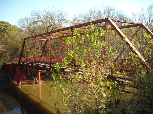


Old Alton Bridge
Bridge · National Register of Historic Places · 6.4 mi
Bridge in Denton County, Texas, United States

Flower Mound Presbyterian Church
Monument and historic site · Presbyterian · 3.8 mi
1501 Flower Mound Road, Flower Mound
Nicole's Fairy Tree
Monument and historic site · 2.1 mi
Community memorial centered around a tree and memorial bench, with a Little Free Chalkbox, sidewalk chalk art, painted rocks and...
4 more on the map.
Parks, trails and playgrounds123

Austin Kent Ellis Park
Park · 4.9 mi
Austin Kent Ellis Park is a 4.6 acre park positioned between Iris Lane Park and the Sylvan Creek Greenbelt. Park amenities include:...
810 South Old Orchard Lane, Lewisville
Mo-Su 06:00-23:00
Brazos Park
Park · 4.9 mi
Brazos Park is a 3.1 acre park located just north of the Municipal Complex. Baseball Practice fields may be reserved online.
190 Brazos Boulevard, Highland Village
Mo-Su 06:00-23:00
Iris Park
Park · 5.0 mi
Has amenities for Basketball (Full Court), a Drinking Fountain, Picnic Tables, a Playground, and Restrooms
1303 Iris Lane, Lewisville
Mo-Su 06:00-23:00
Lower Sellmeyer Park
Park · 4.7 mi
Lower Sellmeyer Park is a 1 acre neighborhood park.
600 Creek Place, Highland Village
Mo-Su 06:00-23:00
Silverthorne Park
Park · 3.9 mi
Features: - Benches - Nature Area - Trail ==This 6.54 acre neighborhood park is located within the Briarhill Addition. The park is...
930 Silverthorne Trail, Highland Village
Mo-Su 06:00-23:00
Turpin Park
Park · 5.0 mi
Turpin Park is a 1.5 acre Neighborhood Park. Features: -Benches -Grills -Open Space -Picnic Tables -Playground
229 Turpin Drive, Highland Village
Mo-Su 06:00-23:00
Unity Park
Park · 3.9 mi
Unity Park is the City's 38 acre Community Park. Unity Park provides many active recreational amenities for residents. The park is...
2200 Briarhill Boulevard, Highland Village
Mo-Su 06:00-23:00
Victoria Park
Park · 4.8 mi
Victoria Park is located within the Texas Utilities power line easement. This neighborhood park is approximately 5.69 acres in size,...
202 Victoria Drive, Highland Village
Mo-Su 06:00-23:00
Rockledge Park
Park · 4.9 mi
3600 Pilot Point, Grapevine
Mo-Su 08:00-sunset; Nov Th[4] off; Dec 25 off
Timber Creek Park
Park · 3.7 mi
1100 Timber Creek Road, Flower Mound
Mo-Su 05:00-23:00
111 more on the map.
Restaurants and cafes237

Awesome Times
Diner · American · 3.6 mi
American Restaurant and Bar
2630 FM 407, Highland Village
Mo-Th,Su 11:00-21:00; Fr,Sa 11:00-10:00

Baskin-Robbins
Ice cream · Ice Cream · 2.5 mi
2704 Cross Timbers Road, Flower Mound
Mo-Th 11:00-22:00; Fr,Sa 11:00-23:00; Su 11:00-22:00

Costa Vida Fresh Mexican Grill
Restaurant · Mexican · 2.7 mi
2628 Long Prairie Road, Flower Mound
Mo-Sa 11:00-21:00; Su off
Curry Up Now
Restaurant · Indian · 2.4 mi
2717 Cross Timbers Road, Flower Mound
Mo-Tu 11:00-21:30, We 11:00-21:00, Th 11:00-21:30, Fr-Sa...
Fish City Grill
Restaurant · Seafood · 2.7 mi
2628 Long Prairie Road, Flower Mound
Mo-Th 11:00-21:00; Fr-Sa 11:00-22:00; Su 11:00-21:00
House of Toro Chophouse & Patio
Restaurant · Steak House · 5.1 mi
1301 Solana Blvd Building 3, Westlake
Tu-Sa 17:00-22:00
IHOP
Restaurant · Breakfast, Pancake · 2.8 mi
2600 Long Prairie Road, Flower Mound
Su-Th 06:00-20:00; Fr-Sa 06:00-24:00
Marty B's
Restaurant · Regional, Barbecue · 3.9 mi
2664 FM 407, Bartonville
Su 11:00-21:00, Mo-Th 11:00-22:00, Fr-Sa 11:00-23:00

Marty B's Coffee
Cafe · Coffee Shop · 3.9 mi
2656 FM 407, Bartonville
Su 07:00-17:00, Mo-Th 06:00-21:00, Fr-Sa 06:00-22:00
Pizza Hut
Restaurant · Pizza · 4.3 mi
1181 Flower Mound Road, Flower Mound
Mo-Th,Su 11:00-22:00; Fr-Sa 11:00-23:00; PH off
Starbucks
Cafe · Coffee Shop · 2.7 mi
5871 Long Prairie Road, Flower Mound
Mo-Fr 05:00-21:00; Sa,Su 05:30-21:00
225 more on the map.
History
Settlement in the area around Flower Mound began when the Presbyterians established a camp in the area in the 1840s. A log cabin, dated around 1850, was discovered preserved within the walls of a home near Liberty Elementary in 2016, providing further proof of settlement. At first, the group held religious camps for two to three weeks at a time. By 1854, residents had established the Flower Mound Presbyterian Church southwest of Lewisville in an area commonly referred to as "Long Prairie". By 1920, the church had 126 members, and the pine-framed building was expanded in 1937. Early settlers such as Andrew Morriss and David Kirkpatrick are memorialized with street names in the town. The area remained sparsely populated for many decades after its initial settlement.
From the History section of Flower Mound, Texas on Wikipedia, under CC BY-SA 4.0.
Where to stay9
Hampton Inn & Suites Trophy Club - Fort Worth North
Motel and hotel · 4.8 mi
525 Plaza Drive, Trophy Club
Dallas/Fort Worth Marriott Solana
Motel and hotel · 5.1 mi
1301 Solana Boulevard, Westlake
Homewood Suites
Motel and hotel · 4.9 mi
2900 East State Highway 114, Trophy Club
Churches and places of worship36
St. Philip the Apostle Catholic Church
Church · Catholic · 0.5 mi
5201 Cross Timbers Road, Flower Mound
Lamb of God Lutheran Church
Church · Lutheran · 3.7 mi
1401 Cross Timbers Road, Flower Mound
Chinn's Chapel United Methodist Church;Chinn Chapel
Church · Methodist · 3.5 mi
1000 Chinn Chapel Road, Lewisville
Shopping34
Gas and EV charging27
Schools, colleges and libraries86
Healthcare43
Texas Health Presbyterian Hospital Flower Mound
Hospital · 2.7 mi
4400 Long Prairie Road, Flower Mound
Map of Flower Mound
250 places. The map loads OpenStreetMap tiles when you open it.
Climate by month
Monthly table
| Month | High | Low | Rain | Snow |
|---|---|---|---|---|
| Jan | 56°F | 34°F | 2.6 in | 0.0 in |
| Feb | 60°F | 38°F | 2.7 in | 0.1 in |
| Mar | 68°F | 45°F | 3.6 in | 0.0 in |
| Apr | 75°F | 54°F | 3.5 in | 0.0 in |
| May | 82°F | 63°F | 4.7 in | 0.0 in |
| Jun | 91°F | 71°F | 3.8 in | 0.0 in |
| Jul | 95°F | 74°F | 2.2 in | 0.0 in |
| Aug | 96°F | 74°F | 2.1 in | 0.0 in |
| Sep | 89°F | 67°F | 3.5 in | 0.0 in |
| Oct | 78°F | 55°F | 4.5 in | 0.0 in |
| Nov | 66°F | 45°F | 2.8 in | 0.0 in |
| Dec | 58°F | 36°F | 2.9 in | 0.0 in |
U.S. Climate Normals 1991-2020 for Grapevine Dam (7 mi away), NOAA NCEI.
People and cost of living
American Community Survey 5-year estimates, 2020-2024, U.S. Census Bureau. Estimates have margins of error, larger for small towns.
Disaster history
Denton County has had 17 federal disaster declarations since 2000, most often for hurricanes.
- 2024-05-17: Severe Storms, Straight-Line Winds, Tornadoes, And Flooding (Flood)
- 2021-02-19: Severe Winter Storms (Severe Ice Storm)
- 2021-02-14: Severe Winter Storm (Severe Ice Storm)
- 2020-03-25: Covid-19 Pandemic (Biological)
- 2020-03-13: Covid-19 (Biological)
- 2015-05-29: Severe Storms, Tornadoes, Straight-Line Winds And Flooding (Severe Storm)
OpenFEMA disaster declarations summaries.
Getting there and nearby towns
Dallas/Fort Worth International Airport (DFW) is the nearest airport with scheduled flights listed in OpenStreetMap, 11 miles away.
- Lewisville 8 mi east, about 13 min by car
- Corinth 8 mi north, about 13 min by car
- Coppell 9 mi southeast, about 14 min by car
- Colleyville 10 mi south, about 17 min by car
- Denton 13 mi north, about 20 min by car
- Carrollton 13 mi east, about 21 min by car
- Euless 13 mi south, about 21 min by car
- Bedford 13 mi south, about 21 min by car
- Irving 15 mi southeast, about 24 min by car
- Frisco 19 mi northeast, about 30 min by car
Drive times are estimates from straight-line distance, not routes.
Local news
Headlines from INDB, the NEMICO news database.
Reviews, tips and questions
Loading what members have shared...
Sources and licences
- NCES EDGE (Public domain): public schools
- NOAA NCEI U.S. Climate Normals 1991-2020 (Public domain): climate by month
- OpenFEMA (Public domain): disaster declarations
- OpenStreetMap contributors (ODbL 1.0): places, airports, map data
- U.S. Census Bureau (Public domain): population, income, housing, education, commute
- Wikidata (CC0 1.0): elevation, founding date, time zone, website, landmarks and historic places
- Wikimedia Commons (see each image): photos
- Wikipedia (CC BY-SA 4.0): overview and history text
Photo credits
- Flower Mound Texas Aerial (49394951597), formulanone, CC BY-SA 2.0
- Foggy Sunday - Flower Mound, Shiva Shenoy, CC BY 2.0
- Flower Mound High 9th Grade Campus Learning Hub, Nadia Eimandoust, Public domain
- Sunset in Flower Mound - Flickr - Shiva Shenoy, Shiva Shenoy from Flower Mound, United States, CC BY 2.0
- Cold January morning in Flower Mound (51797562155), Shiva Shenoy from Flower Mound, United States, CC BY 2.0
- Sturgeon moon - Flower Mound, Shiva Shenoy, CC BY 4.0
- Pink sunset cloud - Flower Mound, Shiva Shenoy, CC BY 4.0
- Cloudy sunset - Flower Mound, Shiva Shenoy, CC BY 4.0
- Harvest Moon - Flower Mound, Shiva Shenoy, CC BY 4.0
- July 4, 2026 fireworks in Flower Mound, Shiva Shenoy, CC BY 4.0
- Storm approaching Flower Mound, Shiva Shenoy, CC BY 2.0
- Sunset in Flower Mound1, Shiva Shenoy, CC BY 2.0
- Old Alton Bridge, Ron from Denton, Texas, CC BY 2.0
- Cardinal in Texas, Shiva Shenoy, CC BY 2.0
- Ictinia mississippiensis1, Shiva Shenoy, CC BY 2.0
- Cookie cutter suburbs in Texas, User:ktr101, CC BY-SA 4.0
- Hogna female ventral, annikaml, CC BY 4.0
- Mycena meliigena (Denton, USA), Haley Daniels, CC BY 4.0
- Jesse the hero, Scrappydoo64, CC BY-SA 4.0
- Zoom Zoom (26509097751), Branden Williams from Flower Mound, TX, USA, CC BY 2.0
- Traffic! Comin' at ya! (26549873986), Branden Williams from Flower Mound, TX, USA, CC BY 2.0
- Scissortails at sunrise - Flickr - Shiva Shenoy, Shiva Shenoy from Flower Mound, United States, CC BY 2.0
- ISS034-E-31966 - View of Earth, Earth Science and Remote Sensing Unit , Lyndon B. Johnson Space Center, Public domain
- ISS032-E-27879 - View of Earth, Earth Science and Remote Sensing Unit , Lyndon B. Johnson Space Center, Public domain
- ISS058-E-7734 - View of Earth, Earth Science and Remote Sensing Unit, NASA Johnson Space Center, Public domain
- ISS040-E-102272 - View of Earth, Earth Science and Remote Sensing Unit , Lyndon B. Johnson Space Center, Public domain
- ISS040-E-102271 - View of Earth, Earth Science and Remote Sensing Unit , Lyndon B. Johnson Space Center, Public domain
- ISS016-E-23053 - View of Earth, Earth Science and Remote Sensing Unit , Lyndon B. Johnson Space Center, Public domain
- ISS040-E-102529 - View of Earth, Earth Science and Remote Sensing Unit , Lyndon B. Johnson Space Center, Public domain
- ISS058-E-7733 - View of Earth, Earth Science and Remote Sensing Unit, NASA Johnson Space Center, Public domain
- Bluebirds in the fog - Flickr - Shiva Shenoy, Shiva Shenoy from Flower Mound, United States, CC BY 2.0
- Female Northern Cardinal at sunset (50877719066), Shiva Shenoy from Flower Mound, United States, CC BY 2.0
- Painted bunting1, Shiva Shenoy, CC BY 4.0
- Close-up of a rock formation near Lake Grapevine (52697282821), Shiva Shenoy from Flower Mound, United States, CC BY 2.0
- American Kestrel (52457135811), Shiva Shenoy from Flower Mound, United States, CC BY 2.0
- Indigo bunting - spring migration 2026 - Flickr - Shiva Shenoy, Shiva Shenoy from Flower Mound, United States, CC BY 4.0
- Coots on a foggy morning at Lake Grapevine (52493192966), Shiva Shenoy from Flower Mound, United States, CC BY 2.0
- WolfSpider F withYoung, Celtikkat, CC BY-SA 4.0
- Lake Grapevine (52551182908), Shiva Shenoy from Flower Mound, United States, CC BY 2.0


Page built October 30, 2026. Spotted a mistake? Tell us or suggest a place.