
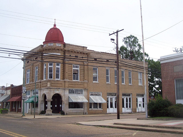


Why visit Fordyce
Townapedia lists 18 museums and landmarks, 2 parks and trails, 4 places to eat and 1 place to stay in and around town.
Highlights include Charlotte Street Historic District and Amis House.
July is the warmest month, with average highs of 91°F; January lows average 31°F.
Weather in Fordyce
Forecast from the National Weather Service. Full forecast
About Fordyce
Fordyce is a city in southeast Dallas County, Arkansas, United States. Its population has been decreasing since the 1980s when the town reached an all-time high of 5,175. The population in 2020 was 3,396, down from 4,300 at the 2010 census, and from 4,799 in 2000.
From the Wikipedia article Fordyce, Arkansas (this version), under CC BY-SA 4.0.
Museums and landmarks18

Charlotte Street Historic District
Monument and historic site · National Register of Historic Places · 0.5 mi
Historic district in Arkansas, United States
Amis House
Monument and historic site · National Register of Historic Places · 0.5 mi
Listed on the NRHP in Arkansas

Cotton Belt Railroad Depot-Fordyce
Monument and historic site · National Register of Historic Places · 0.6 mi
Railway station in Fordyce, the United States of America

Dallas County Courthouse
Monument and historic site · National Register of Historic Places · 0.4 mi
Courthouse in Arkansas, United States
Dallas County Training School High School Building
Monument and historic site · National Register of Historic Places · 0.9 mi
Historic school building in Fordyce, Arkansas, United States
Elliott House
Monument and historic site · National Register of Historic Places · 0.5 mi
Historic house in Arkansas, United States
Fielder House
Monument and historic site · National Register of Historic Places · 0.8 mi
Historic house in Arkansas, United States

Fordyce Commercial Historic District
Monument and historic site · National Register of Historic Places · 0.4 mi
Historic district in Fordyce, Arkansas
Fordyce Home Accident Insurance Company
Monument and historic site · National Register of Historic Places · 0.5 mi
Building in Arkansas, United States
Jessie B. Smith House
Monument and historic site · National Register of Historic Places · 0.6 mi
Historic house in Arkansas, United States
John Russell House
Monument and historic site · National Register of Historic Places · 0.5 mi
Fordyce, Arkansas, listed on the NRHP in Dallas County

Marathon Oil Service Station
Monument and historic site · National Register of Historic Places · 0.5 mi
Filling station in Fordyce, United States of America
6 more on the map.
Parks, trails and playgrounds2

Restaurants and cafes4




Where to stay1

History
Before European settlement, the area was inhabited by the Caddo people, whose artifacts are occasionally found. The land that became Fordyce was partially cleared before 1850 by W. W. Killabrew, an early settler. In the 1870s, the land was owned by an African American named Henry Atkinson, who sold it to Dr. Algernon Sidney Holderness for $118, who built the first sawmill in town.
The town of Fordyce was named for Samuel Wesley Fordyce. Little construction took place until 1881 when four railroad lines were constructed in Dallas County, one of which was surveyed by Samuel Fordyce. The St. Louis Southwestern Railway Company was completed in 1883 under Fordyce's management, which he operated for 16 years. The rail line called the Cotton Belt Line passed through the town of Fordyce until 1940 when the rail lines were abandoned, and trucks on the roads replaced the trains.
By 1890, Fordyce was the largest town in the county, and on April 8, 1908, it became incorporated and the seat of Dallas County.
From the History section of Fordyce, Arkansas on Wikipedia, under CC BY-SA 4.0.
Churches and places of worship6
First Presbyterian Church
Church · Presbyterian · National Register of Historic Places · 0.4 mi
212 West 4th Street
First United Methodist Church
Church · Methodist · National Register of Historic Places · 0.4 mi
Shopping4
Gas and EV charging5
Schools, colleges and libraries5
Healthcare1
Map of Fordyce
46 places. The map loads OpenStreetMap tiles when you open it.
Climate by month
Monthly table
| Month | High | Low | Rain | Snow |
|---|---|---|---|---|
| Jan | 52°F | 31°F | 4.5 in | 0.6 in |
| Feb | 57°F | 34°F | 4.9 in | 0.5 in |
| Mar | 65°F | 41°F | 5.8 in | 0.1 in |
| Apr | 74°F | 49°F | 5.9 in | 0.0 in |
| May | 80°F | 59°F | 5.4 in | 0.0 in |
| Jun | 88°F | 67°F | 4.2 in | 0.0 in |
| Jul | 91°F | 70°F | 4.1 in | 0.0 in |
| Aug | 91°F | 69°F | 3.8 in | 0.0 in |
| Sep | 85°F | 62°F | 3.6 in | 0.0 in |
| Oct | 75°F | 50°F | 5.0 in | 0.0 in |
| Nov | 63°F | 40°F | 4.4 in | 0.0 in |
| Dec | 54°F | 33°F | 6.0 in | 0.0 in |
U.S. Climate Normals 1991-2020 for Fordyce (1 mi away), NOAA NCEI.
People and cost of living
American Community Survey 5-year estimates, 2020-2024, U.S. Census Bureau. Estimates have margins of error, larger for small towns.
Disaster history
Dallas County has had 19 federal disaster declarations since 2000, most often for severe storms.
- 2026-01-24: Severe Winter Storm (Winter Storm)
- 2025-05-21: Severe Storms, Tornadoes, And Flooding (Flood)
- 2025-04-05: Severe Storms, Tornadoes, And Flooding (Severe Storm)
- 2023-04-04: Severe Winter Storm (Winter Storm)
- 2020-08-27: Hurricane Laura (Hurricane)
- 2020-07-10: Severe Storms And Straight-Line Winds (Tornado)
OpenFEMA disaster declarations summaries.
Getting there and nearby towns
Harrell Field (CDH) is the nearest airport with scheduled flights listed in OpenStreetMap, 24 miles away.
- East Camden 24 mi southwest, about 38 min by car
- Camden 30 mi southwest, about 49 min by car
- Pine Bluff 36 mi northeast, about 57 min by car
- Arkadelphia 43 mi northwest, about 1 h 15 min by car
- El Dorado 44 mi south, about 1 h 15 min by car
- Malvern 45 mi northwest, about 1 h 15 min by car
- Benton 53 mi north, about 1 h 30 min by car
- Dumas 54 mi east, about 1 h 30 min by car
- Bryant 55 mi north, about 1 h 30 min by car
- Crossett 55 mi southeast, about 1 h 30 min by car
Drive times are estimates from straight-line distance, not routes.
Local news
Headlines from INDB, the NEMICO news database.
Reviews, tips and questions
Loading what members have shared...
Sources and licences
- NCES EDGE (Public domain): public schools
- NOAA NCEI U.S. Climate Normals 1991-2020 (Public domain): climate by month
- OpenFEMA (Public domain): disaster declarations
- OpenStreetMap contributors (ODbL 1.0): places, airports, map data
- U.S. Census Bureau (Public domain): population, income, housing, education, commute
- Wikidata (CC0 1.0): elevation, founding date, time zone, website, landmarks and historic places
- Wikimedia Commons (see each image): photos
- Wikipedia (CC BY-SA 4.0): overview and history text
Photo credits
- Fordyce Home Accident Insurance Company, Farther Along, CC BY 2.0
- Waters House, Fordyce, AR, Valis55, CC BY-SA 3.0
- Elliott House, Fordyce, AR, Valis55, CC BY-SA 3.0
- First Presbyterian Church in Fordyce, AR, Brandonrush, CC BY-SA 3.0
- First United Methodist Church in Fordyce, Arkansas, Brandonrush, CC BY-SA 3.0
- Wynne House 001, Brandonrush, CC BY-SA 3.0
- Marathon Oil Service Station 001, Brandonrush, CC BY-SA 3.0
- Cotton Belt Railroad Depot 002, Brandonrush, CC BY-SA 3.0
- Cotton Belt Railroad Depot 001, Brandonrush, CC BY-SA 3.0
- Fordyce Commercial Historic District, Brandonrush, CC BY-SA 3.0
- Dallas County Courthouse 001, Brandonrush, CC BY-SA 3.0
- Rock Island Depot 001, Brandonrush, CC BY-SA 3.0
- Amis House, Valis55, CC BY-SA 3.0
- John Russell House, Valis55, CC BY-SA 3.0
- Nutt-Trussell Building, Valis55, CC BY-SA 3.0
- Charlotte Street Historic District, 3 of 6, Valis55, CC BY-SA 3.0
- Charlotte Street Historic District, 6 of 6, Valis55, CC BY-SA 3.0
- Charlotte Street Historic District, 5 of 6, Valis55, CC BY-SA 3.0
- Charlotte Street Historic District, 2 of 6, Valis55, CC BY-SA 3.0
- Charlotte Street Historic District, 1 of 6, Valis55, CC BY-SA 3.0
- Charlotte Street Historic District, 4 of 6, Valis55, CC BY-SA 3.0
- Jessie B. Smith House, Valis55, CC BY-SA 3.0
- Dallas County Training School High School Building, Valis55, CC BY-SA 3.0
- ISS030-E-19097 - View of Arkansas, Earth Science and Remote Sensing Unit , Lyndon B. Johnson Space Center, Public domain
- ISS030-E-58506 - View of Earth, Earth Science and Remote Sensing Unit , Lyndon B. Johnson Space Center, Public domain
- ISS030-E-58507 - View of Earth, Earth Science and Remote Sensing Unit , Lyndon B. Johnson Space Center, Public domain
- ISS012-E-15460 - View of Louisiana, Earth Science and Remote Sensing Unit , Lyndon B. Johnson Space Center, Public domain
- ISS030-E-57408 - View of Earth, Earth Science and Remote Sensing Unit , Lyndon B. Johnson Space Center, Public domain
- ISS030-E-57407 - View of Earth, Earth Science and Remote Sensing Unit , Lyndon B. Johnson Space Center, Public domain


Page built October 30, 2026. Spotted a mistake? Tell us or suggest a place.