

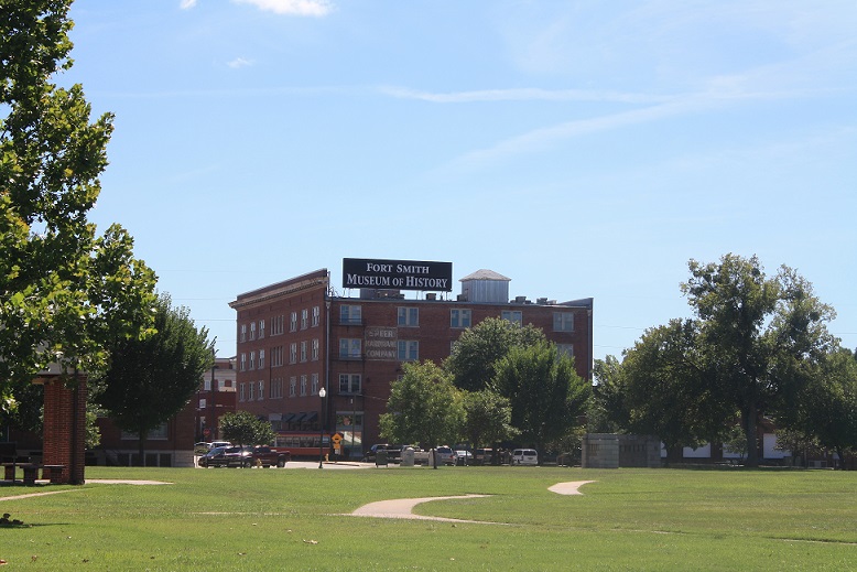


Fort Smith, Arkansas
Fort Smith is a city of 89,805 people in Sebastian County, Arkansas, founded in 1817.
Why visit Fort Smith
Townapedia lists 76 museums and landmarks, 42 parks and trails, 194 places to eat, 27 places to stay and 4 attractions in and around town.
Highlights include Malco Theater, King Opera House, Fort Smith Museum of HIstory and Belle Grove Historic District.
July is the warmest month, with average highs of 94°F; January lows average 30°F.
Weather in Fort Smith
Forecast from the National Weather Service. Full forecast
About Fort Smith
Fort Smith is the third-most populous city in Arkansas, United States, and one of the two county seats of Sebastian County. As of the 2020 census, the population was 89,142. It is the principal city of the Fort Smith, Arkansas–Oklahoma Metropolitan Statistical Area, a region of 298,592 residents that encompasses the Arkansas counties of Crawford, Franklin, and Sebastian, and the Oklahoma counties of LeFlore and Sequoyah.
From the Wikipedia article Fort Smith, Arkansas (this version), under CC BY-SA 4.0.
Things to do4

King Opera House
Cinema and theater · 6.3 mi
Theater in Van Buren, Arkansas

Museums and landmarks76
Fort Smith Museum of HIstory
Museum · National Register of Historic Places · 4.2 mi
History museum in Fort Smith, Arkansas
320 Rogers Avenue, Fort Smith
Tu-Sa 10:00-16:00

Belle Grove Historic District
Monument and historic site · National Register of Historic Places · 4.1 mi
Historic district in Fort Smith, Arkansas


South Side Baptist Church
Monument and historic site · Baptist · National Register of Historic Places · 2.6 mi
Church building in Arkansas, United States of America

Angus McLeod House
Monument and historic site · National Register of Historic Places · 3.6 mi
Historic house in Arkansas, United States
Arkoma School
Monument and historic site · National Register of Historic Places · 3.5 mi
School building in Arkoma, Oklahoma

Bob Burns House
Monument and historic site · National Register of Historic Places · 6.1 mi
Historic house in Arkansas, United States
Bonneville House
Monument and historic site · National Register of Historic Places · 3.9 mi
Historic house in Arkansas, United States
Bryan House
Monument and historic site · National Register of Historic Places · 6.2 mi
Historic house in Arkansas, United States
C.R. Breckinridge House
Monument and historic site · National Register of Historic Places · 3.5 mi
Historic house in Arkansas, United States


Clarke-Harrell-Burson House
Monument and historic site · National Register of Historic Places · 6.9 mi
Historic house in Arkansas, United States
Commercial Hotel
Monument and historic site · National Register of Historic Places · 4.3 mi
NRHP-listed in Sebastian County
64 more on the map.
Parks, trails and playgrounds42


30 more on the map.
Restaurants and cafes194

Asian Bistro
Restaurant · 3.9 mi
Take Out or very limited dine in seating
2503 Market Trace
Tu-Su 11:00-22:30


Fort Smith Coffee Company
Cafe · Coffee Shop · 3.7 mi
1101 Rogers Avenue, Fort Smith
Mo-Su 06:00-22:00
Fuji's
Restaurant · Japanese · 1.7 mi
3600 Massard Road, Fort Smith
Mo-Th 11:00-14:30,16:30-21:00, Fr 11:00-14:30,16:30-22:00, Sa...
La Huerta
Restaurant · Regional · 4.2 mi
400 Garrison Avenue, Fort Smith
Su-Th 11:00-21:00, Fr-Sa 11:00-22:30
La Huerta Mexican Restaurant
Restaurant · Mexican · 4.2 mi
400 Garrison Avenue, Fort Smith
Mo-Th 11:00-21:00; Fr-Sa 11:00-22:30; Su 11:00-14:00
Marco's Pizza
Restaurant · 3.9 mi
Delivery or Take Out
2505 Market Trace
Mo-Th,Su 11:00-22:00; Fr,Sa 11:00-23:00
182 more on the map.
Where to stay27
Churches and places of worship126
Christ the King Church
Church · National Register of Historic Places · 2.2 mi
Hội Thánh Tin Lành Báp Tít Việt Nam;Vietnamese Baptist Church
Church · Baptist · 3.0 mi
2801 Alabama Avenue, Fort Smith
Christ the King Catholic Church
Church · Roman Catholic · 2.2 mi
2112 South Greenwood Avenue, Fort Smith
Love's Chapel Seventh-day Adventist Church
Church · Seventh Day Adventist · 3.9 mi
2034 North 12th Street, Fort Smith
Old School Presbyterian Church (Van Buren, Arkansas)
Church · 6.1 mi
Shopping48
Gas and EV charging34
Schools, colleges and libraries68
Healthcare33
Encompass Health Rehabilitation Hospital of Fort Smith
Hospital · 3.2 mi
1401 South J Street, Fort Smith
Map of Fort Smith
250 places. The map loads OpenStreetMap tiles when you open it.
Climate by month
Monthly table
| Month | High | Low | Rain | Snow |
|---|---|---|---|---|
| Jan | 51°F | 30°F | 2.9 in | 1.4 in |
| Feb | 57°F | 33°F | 2.7 in | 0.6 in |
| Mar | 66°F | 42°F | 3.9 in | 0.3 in |
| Apr | 74°F | 50°F | 4.9 in | 0.0 in |
| May | 81°F | 60°F | 5.6 in | 0.0 in |
| Jun | 89°F | 68°F | 4.6 in | 0.0 in |
| Jul | 94°F | 72°F | 3.4 in | 0.0 in |
| Aug | 94°F | 71°F | 3.6 in | 0.0 in |
| Sep | 86°F | 63°F | 4.0 in | 0.0 in |
| Oct | 76°F | 51°F | 4.4 in | 0.0 in |
| Nov | 63°F | 40°F | 3.9 in | 0.0 in |
| Dec | 53°F | 32°F | 3.5 in | 0.6 in |
U.S. Climate Normals 1991-2020 for Ft Smith Rgnl Ap Gsn 72344 (1 mi away), NOAA NCEI.
People and cost of living
American Community Survey 5-year estimates, 2020-2024, U.S. Census Bureau. Estimates have margins of error, larger for small towns.
Disaster history
Sebastian County has had 15 federal disaster declarations since 2000, most often for severe storms.
- 2026-01-24: Severe Winter Storm (Winter Storm)
- 2025-04-05: Severe Storms, Tornadoes, And Flooding (Severe Storm)
- 2020-08-27: Hurricane Laura (Hurricane)
- 2020-04-03: Covid-19 Pandemic (Biological)
- 2020-03-13: Covid-19 (Biological)
- 2019-06-08: Severe Storms And Flooding (Flood)
OpenFEMA disaster declarations summaries.
Getting there and nearby towns
Fort Smith Regional Airport (FSM) is the nearest airport with scheduled flights listed in OpenStreetMap, 1 miles away.
- Arkoma 5 mi west, about 7 min by car
- Barling 5 mi east, about 8 min by car
- Van Buren 7 mi north, about 11 min by car
- Pocola 9 mi southwest, about 14 min by car
- Roland 9 mi northwest, about 14 min by car
- Greenwood 12 mi southeast, about 19 min by car
- Alma 13 mi northeast, about 21 min by car
- Muldrow 13 mi west, about 21 min by car
- Spiro 16 mi southwest, about 26 min by car
- Dyer 16 mi northeast, about 27 min by car
Drive times are estimates from straight-line distance, not routes.
Local news
Headlines from INDB, the NEMICO news database.
Reviews, tips and questions
Loading what members have shared...
Sources and licences
- NCES EDGE (Public domain): public schools
- NOAA NCEI U.S. Climate Normals 1991-2020 (Public domain): climate by month
- OpenFEMA (Public domain): disaster declarations
- OpenStreetMap contributors (ODbL 1.0): places, airports, map data
- U.S. Census Bureau (Public domain): population, income, housing, education, commute
- Wikidata (CC0 1.0): elevation, founding date, time zone, website, landmarks and historic places
- Wikimedia Commons (see each image): photos
- Wikipedia (CC BY-SA 4.0): overview and history text
Photo credits
- GarrisonFSM, Xltel at English Wikipedia, CC BY-SA 3.0
- Fort Smith, Arkansas History Museum, Eringrapejuice, CC BY-SA 3.0
- Fort Smith Birney streetcar 224 behind Museum of History (1997), Steve Morgan, CC BY-SA 3.0
- FT. SMITH'S BELLE GROVE HISTORIC DISTRICT, JERRYE & ROY KLOTZ MD, CC BY-SA 3.0
- South Side Baptist Church, Front View, Valis55, CC BY-SA 3.0
- Henry "Harry" Charles Pernot House, Valis55, CC BY-SA 4.0
- Clarke-Harrell-Burson House, Valis55, CC BY-SA 3.0
- JAMES SPARKS HOME, JERRYE & ROY KLOTZ MD, CC BY-SA 3.0
- Fairview Cemetery, Confederate Section, Valis55, CC BY-SA 3.0
- Frisco 4003 steam locomotive in 2008, Adam Bartlett from Little Rock, Arkansas, United States, CC BY 2.0
- US Air Force Locomotive 1246 in 2008, Adam Bartlett from Little Rock, Arkansas, United States, CC BY 2.0
- Echols Memorial Christian Church, Front View, Valis55, CC BY-SA 3.0
- Bob Burns House, Krorie, CC BY-SA 3.0
- New Theatre, Front View, Valis55, CC BY-SA 3.0
- Old School Presbyterian Church, Brandonrush, CC BY-SA 3.0
- Fort Smith National Cemetery Jan2011, Tnkntx from Friendswood, USA, CC BY-SA 2.0


Page built October 30, 2026. Spotted a mistake? Tell us or suggest a place.