


Foster City, California
Foster City is a city of 32,792 people in San Mateo County, California, founded in 1971.
Why visit Foster City
Townapedia lists 2 museums and landmarks, 57 parks and trails, 36 places to eat, 4 places to stay and 4 attractions in and around town.
Highlights include Marine World/Africa USA, Notre Dame de Namur University, Ralston Hall and Leo J. Ryan Memorial Park.
July is the warmest month, with average highs of 81°F; December lows average 40°F.
Weather in Foster City
Forecast from the National Weather Service. Full forecast
About Foster City
Foster City is a master-planned city located in San Mateo County, California, United States. Foster City is sometimes considered to be part of Silicon Valley for its local industry and its proximity to Silicon Valley cities. There are many notable companies headquartered in Foster City, such as Gilead Sciences, Zoox, and Replit. Visa and Sledgehammer Games were formerly headquartered in Foster City.
From the Wikipedia article Foster City, California (this version), under CC BY-SA 4.0.
Things to do4
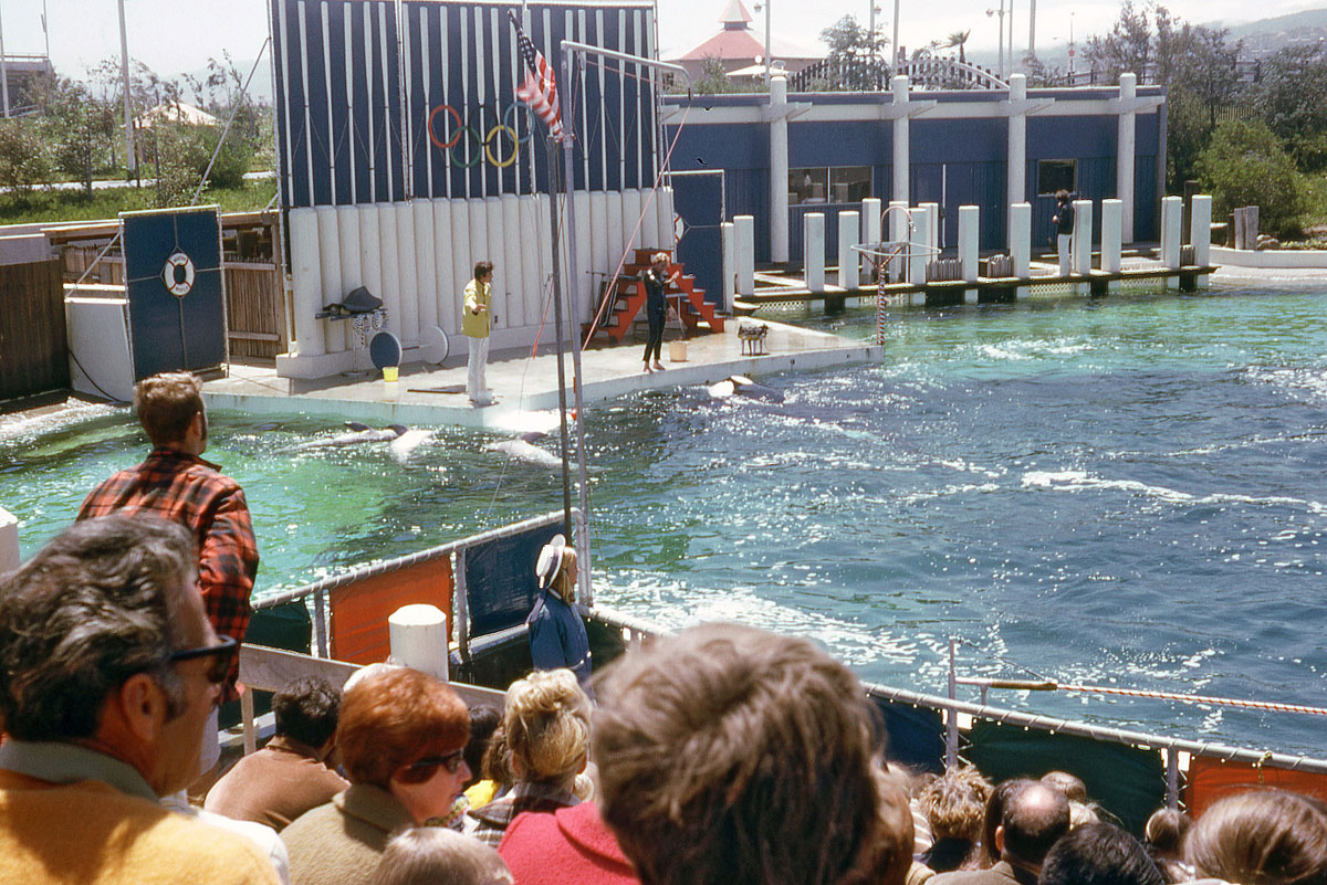
Marine World/Africa USA
Monument and historic site · 2.4 mi
Former animal theme park in California

Notre Dame de Namur University
School · 3.8 mi
Private Catholic university in Belmont, California, United States

San Mateo–Hayward Bridge
Bridge · 1.9 mi
Road bridge across San Francisco Bay in San Mateo County, California, United States

Museums and landmarks2

Ralston Hall
Monument and historic site · National Register of Historic Places · 3.8 mi
Historic house in Belmont, California

Parks, trails and playgrounds57


Leo J. Ryan Memorial Park
Park · 1.2 mi
Recreational city park located in Foster City, California, USA

Davey Glen Park
Park · 3.4 mi
Park in Belmont, United States of America


Bowditch Middle School Auditorium
Sports field and stadium · 0.4 mi
1450 Tarpon Street, Foster City
Gama Ride Amusement Center
Sports field and stadium · 1.7 mi
2200 Bridgepointe Parkway, San Mateo

45 more on the map.
Restaurants and cafes36

Starbucks
Cafe · Coffee Shop · 1.3 mi
1000 Metro Center Boulevard, Foster City
Mo-Su 04:30-19:00; Fr,Sa 04:30-19:30

BJ's
Diner · American · 1.8 mi
2206 Bridgepointe Parkway
Mo-Fr 11:00-24:00; Sa,Su 00:00-01:00,10:00-24:00

Lazy Dog
Diner · American · 1.8 mi
2208 Bridgepointe Parkway, San Mateo
Mo-Fr 11:00-24:00; Sa,Su 10:00-24:00
Armadillo Willy's
Restaurant · Barbecue · 1.7 mi
2260
Mo-Su 11:00-20:00; Fr,Sa 11:00-20:30
Benihana
Restaurant · Japanese, Teppanyaki, Steak · 1.7 mi
Bridgepointe Parkway, San Mateo
Mo-Su 11:00-22:00; Fr,Sa 11:00-23:00
IHOP
Restaurant · Breakfast, Pancake · 1.1 mi
531 Foster City Boulevard, Foster City
Mo-Th 06:30-23:00; Fr 06:30-24:00; Sa 00:00-01:45,06:30-24:00; Su...
SeeU Cafe
Cafe
1465 Beach Park Boulevard, Foster City
Tu-Sa 07:00 - 22:00; Su 09:00-16:00; Mo off; "Events longer"
MJ Sushi
Restaurant · 1.4 mi
977 East Hillsdale Boulevard, Foster City
Mo-Su 11:30-21:30
24 more on the map.
History
Foster City was founded in the 1960s, built on the existing Brewer Island in the marshes of the San Francisco Bay on the east edge of San Mateo, enlarged with engineered landfill. The city was named after T. Jack Foster, a real estate magnate who owned much of the land comprising the city and who was instrumental in its initial design. His firm, Foster Enterprises, now run by his descendants, relocated to San Mateo in 2000 and is still active in real estate affairs throughout the San Francisco Bay Area.
The first residents moved into Foster City on March 7, 1964. Charles Zerbe, a San Francisco firefighter with a wife and two young sons, paid $23,500 for his four-bedroom house on Pilgrim Drive.
In the early 1960s, the first homes built in Foster City were sold for under $18,000. By the late 1960s, the average home price was just under $30,000. United States census data shows the median household income for Foster City residents in 1970 was $30,000 and in 1980 was $60,000. As of 2020, the median household income for Foster City was $161,000. In 2024, the average home value was $1,926,381.
From the History section of Foster City, California on Wikipedia, under CC BY-SA 4.0.
Where to stay4
Churches and places of worship7
Shopping8
Gas and EV charging6
Schools, colleges and libraries47
Healthcare1
Map of Foster City
172 places. The map loads OpenStreetMap tiles when you open it.
Climate by month
Monthly table
| Month | High | Low | Rain | Snow |
|---|---|---|---|---|
| Jan | 59°F | 40°F | 3.8 in | 0.0 in |
| Feb | 62°F | 42°F | 3.6 in | 0.0 in |
| Mar | 65°F | 45°F | 3.0 in | 0.0 in |
| Apr | 68°F | 46°F | 1.1 in | 0.0 in |
| May | 73°F | 50°F | 0.5 in | 0.0 in |
| Jun | 79°F | 54°F | 0.2 in | 0.0 in |
| Jul | 81°F | 57°F | 0.0 in | 0.0 in |
| Aug | 81°F | 56°F | 0.0 in | 0.0 in |
| Sep | 79°F | 54°F | 0.1 in | 0.0 in |
| Oct | 75°F | 50°F | 0.9 in | 0.0 in |
| Nov | 65°F | 44°F | 1.9 in | 0.0 in |
| Dec | 59°F | 40°F | 3.9 in | 0.0 in |
U.S. Climate Normals 1991-2020 for Redwood City (6 mi away), NOAA NCEI.
People and cost of living
American Community Survey 5-year estimates, 2020-2024, U.S. Census Bureau. Estimates have margins of error, larger for small towns.
Disaster history
San Mateo County has had 14 federal disaster declarations since 2000, most often for floods.
- 2023-04-03: Severe Winter Storms, Straight-Line Winds, Flooding, Landslides, And Mudslides (Severe Storm)
- 2023-03-10: Severe Winter Storms, Flooding, Landslides, And Mudslides (Flood)
- 2023-01-14: Severe Winter Storms, Flooding, Landslides, And Mudslides (Flood)
- 2023-01-09: Severe Winter Storms, Flooding, And Mudslides (Flood)
- 2020-08-22: Wildfires (Fire)
- 2020-08-20: Czu Lightning Fire Complex (Fire)
OpenFEMA disaster declarations summaries.
Getting there and nearby towns
San Carlos Airport (SQL) is the nearest airport with scheduled flights listed in OpenStreetMap, 4 miles away.
- San Mateo 3 mi west, about 5 min by car
- Redwood City 4 mi southeast, about 6 min by car
- Belmont 4 mi southwest, about 7 min by car
- San Carlos 5 mi south, about 7 min by car
- Hillsborough 6 mi west, about 10 min by car
- Burlingame 6 mi west, about 10 min by car
- North Fair Oaks 7 mi southeast, about 11 min by car
- Menlo Park 8 mi southeast, about 13 min by car
- Hayward 9 mi northeast, about 15 min by car
- Millbrae 9 mi west, about 14 min by car
Drive times are estimates from straight-line distance, not routes.
Local news
Headlines from INDB, the NEMICO news database.
Reviews, tips and questions
Loading what members have shared...
Sources and licences
- NCES EDGE (Public domain): public schools
- NOAA NCEI U.S. Climate Normals 1991-2020 (Public domain): climate by month
- OpenFEMA (Public domain): disaster declarations
- OpenStreetMap contributors (ODbL 1.0): places, airports, map data
- U.S. Census Bureau (Public domain): population, income, housing, education, commute
- Wikidata (CC0 1.0): elevation, founding date, time zone, website, landmarks and historic places
- Wikimedia Commons (see each image): photos
- Wikipedia (CC BY-SA 4.0): overview and history text
Photo credits
- Foster City aerial view, February 2018, Pi.1415926535, CC BY-SA 3.0
- Foster city residential area, Alfred Twu, CC0
- Foster City industrial and commercial area, Alfred Twu, CC0
- Uzbek Cultural Festival in Foster City, California (September 18, 2022) - 8, Suiren2022, CC BY-SA 4.0
- Uzbek Cultural Festival in Foster City, California (September 18, 2022) - 9, Suiren2022, CC BY-SA 4.0
- Uzbek Cultural Festival in Foster City, California (September 18, 2022) - 6, Suiren2022, CC BY-SA 4.0
- Uzbek Cultural Festival in Foster City, California (September 18, 2022) - 7, Suiren2022, CC BY-SA 4.0
- Uzbek Cultural Festival in Foster City, California (September 18, 2022) - 5, Suiren2022, CC BY-SA 4.0
- Uzbek Cultural Festival in Foster City, California (September 18, 2022) - 2, Suiren2022, CC BY-SA 4.0
- Uzbek Cultural Festival in Foster City, California (September 18, 2022) - 13, Suiren2022, CC BY-SA 4.0
- Uzbek Cultural Festival in Foster City, California (September 18, 2022) - 3, Suiren2022, CC BY-SA 4.0
- Uzbek Cultural Festival in Foster City, California (September 18, 2022) - 12, Suiren2022, CC BY-SA 4.0
- Uzbek Cultural Festival in Foster City, California (September 18, 2022) - 11, Suiren2022, CC BY-SA 4.0
- Uzbek Cultural Festival in Foster City, California (September 18, 2022) - 4, Suiren2022, CC BY-SA 4.0
- Uzbek Cultural Festival in Foster City, California (September 18, 2022) - 15, Suiren2022, CC BY-SA 4.0
- Uzbek Cultural Festival in Foster City, California (September 18, 2022) - 14, Suiren2022, CC BY-SA 4.0
- Gull Park, Foster City, CA, Suiren2022, CC BY-SA 4.0
- Uzbek Cultural Festival in Foster City, California (September 18, 2022) - 10, Suiren2022, CC BY-SA 4.0
- Uzbek Cultural Festival in Foster City, California (September 18, 2022) - 1, Suiren2022, CC BY-SA 4.0
- Ralston hall, Created by Kglavin, CC BY-SA 3.0
- Leo J. Ryan Memorial Park 13 2019-04-16, F ASTILY, CC BY-SA 4.0
- San Mateo-Hayward Center Span, Peter Kaminski from San Francisco, California, USA, CC BY 2.0
- MarineWorld1970, Dan Wildhirt, CC BY-SA 3.0
- Lobelia erinus plant (05), ahaislip, CC0
- View of California from Flight 2438 LAX-SFO 2016 27, Photograph by Mike Peel ( www.mikepeel.net )., CC BY-SA 4.0
- Coprinellus micaceus 80337884, ahaislip, CC0
- Hirschfeldia incana plant (20), ahaislip, CC0
- Badumna longinqua web, ahaislip, CC0
- Idli for breakfast, Ramesh lalwani, CC BY-SA 4.0
- San Mateo – Hayward Bridge 1 2018-09-28, F ASTILY, CC BY-SA 4.0
- Shorebird Park 4 2018-09-28, F ASTILY, CC BY-SA 4.0
- San Mateo – Hayward Bridge 2 2018-09-28, F ASTILY, CC BY-SA 4.0
- San Mateo – Hayward Bridge 3 2018-09-28, F ASTILY, CC BY-SA 4.0
- Shorebird Park 3 2018-09-28, F ASTILY, CC BY-SA 4.0
- Shorebird Park 23 2018-09-28, F ASTILY, CC BY-SA 4.0
- Shorebird Park 19 2018-09-28, F ASTILY, CC BY-SA 4.0
- Shorebird Park 20 2018-09-28, F ASTILY, CC BY-SA 4.0
- Shorebird Park 18 2018-09-28, F ASTILY, CC BY-SA 4.0
- Shorebird Park 17 2018-09-28, F ASTILY, CC BY-SA 4.0
- Shorebird Park 5 2018-09-28, F ASTILY, CC BY-SA 4.0


Page built October 30, 2026. Spotted a mistake? Tell us or suggest a place.