
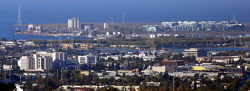


Redwood City, California
Redwood City is a city of 82,447 people in San Mateo County, California.
Why visit Redwood City
Townapedia lists 30 museums and landmarks, 73 parks and trails, 294 places to eat, 27 places to stay and 10 attractions in and around town.
Highlights include Fox Theatre, Redwood Downtown 20 and XD, San Mateo County History Museum and Union Cemetery.
July is the warmest month, with average highs of 81°F; December lows average 40°F.
Weather in Redwood City
Forecast from the National Weather Service. Full forecast
About Redwood City
Redwood City is a city in San Mateo County, California, United States, on the San Francisco Peninsula in the Bay Area of Northern California, approximately 27 miles (43 km) south of San Francisco and 24 miles (39 km) northwest of San Jose. The city's population was 84,292 according to the 2020 census. The Port of Redwood City is the only deepwater port on San Francisco Bay south of San Francisco.
From the Wikipedia article Redwood City, California (this version), under CC BY-SA 4.0.
Things to do10

Fox Theatre
Cinema and theater · National Register of Historic Places · 2.2 mi
Movie theater in Redwood City, California, United States
2215 Broadway, Redwood City

Circle Star Theater
Cinema and theater · 1.9 mi
Former theater in San Carlos, California

Dumbarton Rail Bridge
Bridge · 5.5 mi
Sole heavy rail-compatible crossing of the San Francisco Bay

Marine World/Africa USA
Monument and historic site · 3.0 mi
Former animal theme park in California

Notre Dame de Namur University
School · 4.0 mi
Private Catholic university in Belmont, California, United States
San Mateo–Hayward Bridge
Bridge · 5.5 mi
Road bridge across San Francisco Bay in San Mateo County, California, United States

Museums and landmarks30
San Mateo County History Museum
Museum · National Register of Historic Places · 2.1 mi
Museum in Redwood City, United States of America
2200 Broadway Street, Redwood City


Union Cemetery
Monument and historic site · National Register of Historic Places · 2.9 mi
Historic cemetery in Redwood City, California
Brittan Party House
Monument and historic site · National Register of Historic Places · 3.3 mi
Historical building in San Carlos, California
Dunker House
Monument and historic site · National Register of Historic Places · 5.3 mi
Historic house in California, United States
Fraternal Hall Building
Monument and historic site · National Register of Historic Places · 5.7 mi
Single-family detached home in Palo Alto, United States of America
Holbrook-Palmer Estate
Monument and historic site · National Register of Historic Places · 3.7 mi
Estate in Atherton, California, listed in the National Register of Historic Places
Hostess House
Monument and historic site · National Register of Historic Places · 5.7 mi
Historical Palo Alto building
John Adam Squire House
Monument and historic site · National Register of Historic Places · 5.4 mi
Historic house in Palo Alto, California, USA

Lathrop House
Museum · National Register of Historic Places · 2.1 mi
Historic building in Redwood City, California constructed by Benjamin Gordon Lathrop
Palo Alto Transit Center
Monument and historic site · National Register of Historic Places · 5.6 mi
Railway station in Palo Alto, California
Ralston Hall
Monument and historic site · National Register of Historic Places · 4.0 mi
Historic house in Belmont, California
Ramona Street Architectural District
Monument and historic site · National Register of Historic Places · 5.6 mi
Historic district in California, United States
18 more on the map.
Parks, trails and playgrounds73


Davey Glen Park
Park · 4.0 mi
Park in Belmont, United States of America
Leo J. Ryan Memorial Park
Park · 4.4 mi
Recreational city park located in Foster City, California, USA
Pacific Shores Center
Park · 0.6 mi
Business park in Redwood City, California, United States

61 more on the map.
Restaurants and cafes294

Amici's Pizzeria
Restaurant · Pizza · 2.1 mi
226 Redwood Shores Parkway
Su-Th 11:30-21:00; Fr-Sa 11:30-22:00

Bagel Street Cafe
Cafe · Bagel · 2.1 mi
254 Redwood Shores Parkway
Mo-Fr 06:00-15:00; Sa 06:00-14:00; Su 07:00-14:00
Bangkok Bay
Restaurant · Thai · 2.3 mi
825 Broadway, Redwood City
Mo-Fr 11:00-14:00,17:00-20:30; Sa-Su 17:00-20:30
Falafel Tazah
Restaurant · International, Mediterranean · 2.1 mi
256 Redwood Shores Parkway, Redwood City
Mo-Fr 11:00-20:00; Sa-Su 11:00-19:00
Hobee's Restaurant
Restaurant · Breakfast, Brunch · 3.1 mi
1101 Shoreway Road, Belmont
Mo-Su 08:00-14:00
282 more on the map.
History
The earliest known inhabitants of the area that would become Redwood City were the Ohlone, who were present when the Spanish claimed the land and established missions.
Redwood City incorporated in 1867, being the first city in San Mateo County to do so; it has remained the county seat since the county's formation in 1856. The land had been part of the Rancho de las Pulgas granted to the Argüello family in 1835 by the Mexican government. Their control was challenged after the Mexican–American War when California became part of the United States. The family lawyer, Simon M. Mezes, in 1854 defended the claim somewhat successfully and was allowed to buy the part of the estate that is now Redwood City. Mezes sold some of the land to people already squatting on it along the banks of Redwood Creek and named the settlement "Mezesville". Though the city did not keep that name, Mezes Park still exists on land that Mezes had given for open space.
In 1907, Eikichi and Sadakusi Enomoto, Japanese immigrant brothers, grew what may perhaps have been the first commercially grown chrysanthemums in the United States in Redwood City. In 1926, the chamber of commerce proclaimed the city the "Chrysanthemum Center of the World" though the internment of Japanese Americans in 1941 and other factors would contribute to the end of flower growing as a major industry in the city.
From the History section of Redwood City, California on Wikipedia, under CC BY-SA 4.0.
Where to stay27
Residence Inn Redwood City San Carlos
Motel and hotel · 2.3 mi
800 East San Carlos Avenue, San Carlos
Churches and places of worship26
Church of the Nativity
Church · National Register of Historic Places · 4.2 mi
Episcopal Church of the Epiphany of San Carlos, California
Church · 2.8 mi
Central Bay Community Baptist Church
Church · Baptist · 2.3 mi
1204 Middlefield Road, Redwood City
First United Methodist Church
Church · Methodist · 2.4 mi
2915 Broadway, Redwood City
Saint Peter's Episcopal Church
Church · Episcopal · 2.5 mi
178 Clinton Street, Redwood City
Shopping56
Gas and EV charging33
Schools, colleges and libraries73
Sequoia High School
School · National Register of Historic Places · 2.5 mi
1201 Brewster Avenue, Redwood City
Fair Oaks Branch Redwood City Public Library
Library · 2.6 mi
2510 Middlefield Road, Redwood City
Summit Preparatory Charter High School
School · 2.0 mi
890 Broadway Street, Redwood City
San Carlos Branch San Mateo County Library
Library · 2.8 mi
610 Elm Street, San Carlos
Healthcare18
Dignity Health Medical Group Sequoia
Clinic and pharmacy · 3.0 mi
1301 Shoreway, Belmont
Map of Redwood City
250 places. The map loads OpenStreetMap tiles when you open it.
Climate by month
Monthly table
| Month | High | Low | Rain | Snow |
|---|---|---|---|---|
| Jan | 59°F | 40°F | 3.8 in | 0.0 in |
| Feb | 62°F | 42°F | 3.6 in | 0.0 in |
| Mar | 65°F | 45°F | 3.0 in | 0.0 in |
| Apr | 68°F | 46°F | 1.1 in | 0.0 in |
| May | 73°F | 50°F | 0.5 in | 0.0 in |
| Jun | 79°F | 54°F | 0.2 in | 0.0 in |
| Jul | 81°F | 57°F | 0.0 in | 0.0 in |
| Aug | 81°F | 56°F | 0.0 in | 0.0 in |
| Sep | 79°F | 54°F | 0.1 in | 0.0 in |
| Oct | 75°F | 50°F | 0.9 in | 0.0 in |
| Nov | 65°F | 44°F | 1.9 in | 0.0 in |
| Dec | 59°F | 40°F | 3.9 in | 0.0 in |
U.S. Climate Normals 1991-2020 for Redwood City (3 mi away), NOAA NCEI.
People and cost of living
American Community Survey 5-year estimates, 2020-2024, U.S. Census Bureau. Estimates have margins of error, larger for small towns.
Disaster history
San Mateo County has had 14 federal disaster declarations since 2000, most often for floods.
- 2023-04-03: Severe Winter Storms, Straight-Line Winds, Flooding, Landslides, And Mudslides (Severe Storm)
- 2023-03-10: Severe Winter Storms, Flooding, Landslides, And Mudslides (Flood)
- 2023-01-14: Severe Winter Storms, Flooding, Landslides, And Mudslides (Flood)
- 2023-01-09: Severe Winter Storms, Flooding, And Mudslides (Flood)
- 2020-08-22: Wildfires (Fire)
- 2020-08-20: Czu Lightning Fire Complex (Fire)
OpenFEMA disaster declarations summaries.
Getting there and nearby towns
San Carlos Airport (SQL) is the nearest airport with scheduled flights listed in OpenStreetMap, 2 miles away.
- North Fair Oaks 3 mi south, about 5 min by car
- San Carlos 3 mi west, about 5 min by car
- Foster City 4 mi northwest, about 6 min by car
- Menlo Park 4 mi southeast, about 7 min by car
- Belmont 4 mi west, about 7 min by car
- East Palo Alto 6 mi southeast, about 9 min by car
- San Mateo 6 mi northwest, about 10 min by car
- Stanford 7 mi south, about 11 min by car
- Palo Alto 9 mi southeast, about 15 min by car
- Hayward 10 mi northeast, about 16 min by car
Drive times are estimates from straight-line distance, not routes.
Local news
Headlines from INDB, the NEMICO news database.
Reviews, tips and questions
Loading what members have shared...
Sources and licences
- NCES EDGE (Public domain): public schools
- NOAA NCEI U.S. Climate Normals 1991-2020 (Public domain): climate by month
- OpenFEMA (Public domain): disaster declarations
- OpenStreetMap contributors (ODbL 1.0): places, airports, map data
- U.S. Census Bureau (Public domain): population, income, housing, education, commute
- Wikidata (CC0 1.0): elevation, founding date, time zone, website, landmarks and historic places
- Wikimedia Commons (see each image): photos
- Wikipedia (CC BY-SA 4.0): overview and history text
Photo credits
- Redwoodcitypanorama, User:Coolcaesar . Original uploader was Coolcaesar at en.wikipedia, CC BY-SA 3.0
- The San Mateo County History Museum, SPUCLA, CC BY-SA 4.0
- New Sequoia Theater Building, 2211-2235 Broadway, Redwood City, CA 9-5-2011 5-31-31 PM, Sanfranman59, CC BY-SA 3.0
- USA-Redwood City-Sequoia Union High School-3, Eugene Zelenko, CC BY-SA 4.0
- Union Cemetery (Memorial Day, 2009), User:Wwoods, CC BY-SA 3.0
Page built October 30, 2026. Spotted a mistake? Tell us or suggest a place.