


Why visit Garfield
Townapedia lists 28 museums and landmarks, 21 parks and trails, 60 places to eat, 1 place to stay and 7 attractions in and around town.
Highlights include Capitol Theatre, Gregory Avenue Bridge, Eastside Park and Anderson Street.
July is the warmest month, with average highs of 87°F; January lows average 26°F.
Weather in Garfield
Forecast from the National Weather Service. Full forecast
About Garfield
Garfield is a city in Bergen County in the U.S. state of New Jersey. As of the 2020 United States census, the city's population was 32,655, an increase of 2,168 (+7.1%) from the 2010 census count of 30,487, which in turn reflected an increase of 701 (+2.4%) from the 29,786 counted in the 2000 census.
From the Wikipedia article Garfield, New Jersey (this version), under CC BY-SA 4.0.
Things to do7

Capitol Theatre
Cinema and theater · 1.5 mi
Former movie theater in Passaic, New Jersey, United States

Gregory Avenue Bridge
Bridge · 1.9 mi
Bridge in United States of America
Market Street Bridge
Bridge · 1.4 mi
Bridge in Passaic & Wallington, New Jersey
Monroe Street Bridge
Bridge · 0.8 mi
Bridge in Passaic and Garfield, New Jersey, United States
Passaic Street Bridge
Bridge · 1.0 mi
Steel girder road bridge across the Lower Passaic River in northern New Jersey
Union Avenue Bridge
Bridge · 2.7 mi
Bridge in United States of America
Museums and landmarks28

Eastside Park
Monument and historic site · National Register of Historic Places · 2.9 mi
Historic district in Paterson, New Jersey

Anderson Street
Monument and historic site · National Register of Historic Places · 3.5 mi
Rail station in NJ
Aycrigg Mansion
Monument and historic site · National Register of Historic Places · 2.2 mi
Historic building in Passaic, New Jersey
Bergen County Court House
Monument and historic site · National Register of Historic Places · 3.4 mi
Municipal edifice in New Jersey

Botany Worsted Mills Historic District
Monument and historic site · National Register of Historic Places · 0.7 mi
Historic district in New Jersey, United States

Brinkerhoff House
Monument and historic site · National Register of Historic Places · 2.6 mi
Historic house in Wood-Ridge, New Jersey, USA
Cornelius Demarest House
Monument and historic site · National Register of Historic Places · 1.9 mi
Historic house in Rochelle Park, New Jersey

Dundee Canal
Monument and historic site · National Register of Historic Places · 0.7 mi
Historic canal in Passaic County, New Jersey
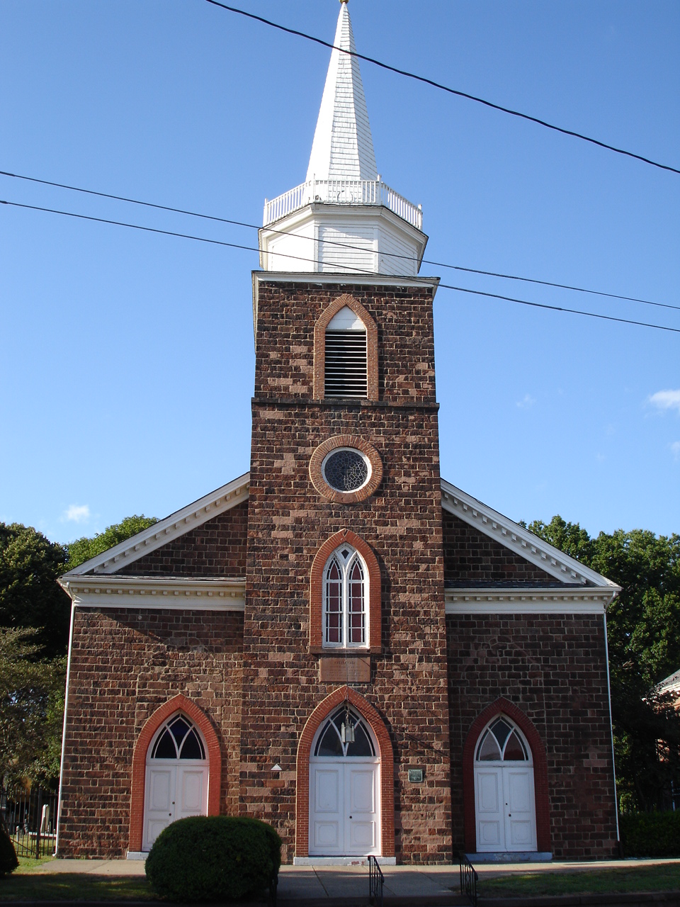
First Reformed Dutch Church
Monument and historic site · National Register of Historic Places · 3.4 mi
Historic church in Hackensack, New Jersey, United States
Fridolin Arnault House
Monument and historic site · National Register of Historic Places · 2.6 mi
Historic house in New Jersey, United States

Garretson Forge and Farm
Monument and historic site · National Register of Historic Places · 3.3 mi
Building in New Jersey, United States


Garritse-Doremus-Westervelt House
Museum · National Register of Historic Places · 2.1 mi
Historic farmhouse in Clifton, New Jersey
16 more on the map.
Parks, trails and playgrounds21

9 more on the map.
Restaurants and cafes60

Baskin-Robbins
Ice cream · Ice Cream · 1.6 mi
699 Avalon Drive, Wood Ridge
Mo-Fr 05:00-21:00; Sa 06:00-21:00; Su 06:00-18:00

Buffalo Wild Wings 'Go'
Restaurant · Chicken · 1.3 mi
487 Market Street, Saddle Brook
Mo-Th, Su 11:00-23:00; Fr,Sa 11:00-24:00
Donna's Pizza
Restaurant · Pizza · 1.3 mi
487 Market Street, Saddle Brook
Mo-Sa 11:00-22:00; Su 12:00-22:00
Dynasty Buffet
Restaurant · Buffet · 1.4 mi
383 Market Street, Saddle Brook
Mo,We,Th,Su 11:30-21:30; Fr,Sa 11:30-22:00
East Wok
Restaurant · Chinese · 1.3 mi
519 Market Street, Saddle Brook
Su 12:00-21:00; Mo, We-Th 11:00-21:00; Fr-Sa 11:00-22:00
Matsuya
Restaurant · Japanese · 1.3 mi
490 Market Street, Saddle Brook
Su 14:00-22:00; Tu-Th 16:30-22:00; Fr 16:30-23:00; Sa 14:00-23:00

Midland Bagels & Grill
Bakery · Bagel · 1.6 mi
160 North Midland Avenue, Saddle Brook
Tu-Fr 06:00-14:00; Sa 06:30-14:00; Su 07:00-14:00
Mr Bruno's Pizza
Restaurant · Pizza · 1.3 mi
472 Market Street, Saddle Brook
Su 11:00-22:00; Mo-Th 10:00-22:00; Fr-Sa 10:00-23:00
Pizza Hut
Restaurant · Pizza · 1.2 mi
536 Market Street, Saddle Brook
Mo-Th,Su 10:00-25:00; Fr,Sa 10:00-26:00
Que Pasta
Restaurant · Italian · 1.4 mi
326 Market Street, Saddle Brook
Tu-Th 11:30-21:30; Fr 11:30-22:00; Su 11:30-21:00
Ricoy Pizzeria & Restaurant
Restaurant · Pizza, Italian, Mexican · 1.3 mi
152 8th Street, Passaic
Mo-Su 11:00-00:00

48 more on the map.
History
Long the home of the Lenape, Native Americans, European settlement in the area that would become Garfield dates back to 1679, when Jacques Cortelyou acquired more than 5,000 acres (2,000 ha) of land surrounding the Passaic River known as "Acqueyquinonke", that ran from the Saddle River to present day Glen Rock.
When the area that is now Garfield was first developed in 1873 with an initial group of seven homes constructed by Gilbert D. Bogart, it was known as East Passaic.
In 1881, the community's name was changed to Garfield in honor of President of the United States James Garfield. There are two explanations given for the circumstances behind the renaming. According to one, shortly after Garfield was elected to the presidency the founder of East Passaic said, "tell everyone...don't speak of East Passaic anymore; call it 'Garfield' after the man who will lead this great country to prosperity." Seven months later, President Garfield was assassinated but his name remained with the community. The second theory holds that after Garfield's death in 1881, a new train station was named in his honor, which in turn led to the surrounding area becoming associated with his name as well.
From the History section of Garfield, New Jersey on Wikipedia, under CC BY-SA 4.0.
Where to stay1
Churches and places of worship33
St. John's Evangelical Lutheran Church
Church · National Register of Historic Places · 1.3 mi
Russian Orthodox Church of Three Saints
Church · Russian Orthodox · 0.7 mi
474 Outwater Lane, Garfield
Saint Michael the Archangel Church
Church · Catholic · 1.1 mi
112 1st Street, Passaic
Saint Nicholas Ukrainian Catholic Church
Church · Ukrainian Greek Catholic · 1.1 mi
217 President Street
Shopping16
Gas and EV charging4
Schools, colleges and libraries87
Saint Nicholas School;Українська школа Святого Миколая
School · Ukrainian Greek Catholic · 1.2 mi
223 President Street
Bergen County Technical High School - Paramus
School · 6.0 mi
E.285 Pascack Road, Paramus
Healthcare7
Kessler Institute For Rehabilitation - Saddle Brook
Hospital · 1.4 mi
300 Market Street, Saddle Brook
Saddle Brook Medical Center
Clinic and pharmacy · 1.4 mi
383 Market Street, Saddle Brook
Map of Garfield
250 places. The map loads OpenStreetMap tiles when you open it.
Climate by month
Monthly table
| Month | High | Low | Rain |
|---|---|---|---|
| Jan | 40°F | 26°F | 3.3 in |
| Feb | 43°F | 27°F | 2.8 in |
| Mar | 51°F | 34°F | 4.1 in |
| Apr | 62°F | 44°F | 4.0 in |
| May | 73°F | 53°F | 3.9 in |
| Jun | 82°F | 63°F | 4.2 in |
| Jul | 87°F | 69°F | 4.5 in |
| Aug | 85°F | 67°F | 4.2 in |
| Sep | 78°F | 60°F | 4.1 in |
| Oct | 67°F | 48°F | 3.7 in |
| Nov | 56°F | 38°F | 3.3 in |
| Dec | 45°F | 31°F | 4.1 in |
U.S. Climate Normals 1991-2020 for Teterboro Ap (3 mi away), NOAA NCEI.
People and cost of living
American Community Survey 5-year estimates, 2020-2024, U.S. Census Bureau. Estimates have margins of error, larger for small towns.
Disaster history
Bergen County has had 21 federal disaster declarations since 2000, most often for hurricanes.
- 2021-09-05: Remnants Of Hurricane Ida (Hurricane)
- 2021-09-02: Remnants Of Hurricane Ida (Hurricane)
- 2020-12-11: Tropical Storm Isaias (Hurricane)
- 2020-03-25: Covid-19 Pandemic (Biological)
- 2020-03-13: Covid-19 (Biological)
- 2018-06-08: Severe Winter Storm And Snowstorm (Severe Storm)
OpenFEMA disaster declarations summaries.
Getting there and nearby towns
Teterboro Airport (TEB) is the nearest airport with scheduled flights listed in OpenStreetMap, 3 miles away.
- Elmwood Park 2 mi north, about 3 min by car
- Wallington 2 mi south, about 3 min by car
- Hasbrouck Heights 2 mi southeast, about 3 min by car
- Wood-Ridge 2 mi southeast, about 4 min by car
- Clifton 3 mi southwest, about 5 min by car
- Maywood 3 mi northeast, about 5 min by car
- Paterson 4 mi northwest, about 6 min by car
- Fair Lawn 4 mi north, about 6 min by car
- East Rutherford 4 mi south, about 7 min by car
- Woodland Park 5 mi west, about 7 min by car
Drive times are estimates from straight-line distance, not routes.
Local news
Headlines from INDB, the NEMICO news database.
Reviews, tips and questions
Loading what members have shared...
Sources and licences
- NCES EDGE (Public domain): public schools
- NOAA NCEI U.S. Climate Normals 1991-2020 (Public domain): climate by month
- OpenFEMA (Public domain): disaster declarations
- OpenStreetMap contributors (ODbL 1.0): places, airports, map data
- U.S. Census Bureau (Public domain): population, income, housing, education, commute
- Wikidata (CC0 1.0): elevation, founding date, time zone, website, landmarks and historic places
- Wikimedia Commons (see each image): photos
- Wikipedia (CC BY-SA 4.0): overview and history text
Photo credits
- Garfield, New Jersey (2015), Adam Moss from Highland Park, NJ, United States, CC BY-SA 2.0
- Garfield High School, NJ, Jan. 2025, Mr. Matté (if there is an issue with this image, contact me using this image's Commons talk page , my Commons user talk page , or my English Wikipedia user talk page ; I'll know about it a lot faster), CC BY-SA 4.0
- Belmont Hill County Park, Garfield, NJ, Jan. 2025, Mr. Matté (if there is an issue with this image, contact me using this image's Commons talk page , my Commons user talk page , or my English Wikipedia user talk page ; I'll know about it a lot faster), CC BY-SA 4.0
- Garfield, NJ city hall diagonal view, Jan. 2025, Mr. Matté (if there is an issue with this image, contact me using this image's Commons talk page , my Commons user talk page , or my English Wikipedia user talk page ; I'll know about it a lot faster), CC BY-SA 4.0
- Garfield, NJ city hall front view, Jan. 2025, Mr. Matté (if there is an issue with this image, contact me using this image's Commons talk page , my Commons user talk page , or my English Wikipedia user talk page ; I'll know about it a lot faster), CC BY-SA 4.0
- Garfield Fire Company 4, Garfield, NJ, Jan. 2025, Mr. Matté (if there is an issue with this image, contact me using this image's Commons talk page , my Commons user talk page , or my English Wikipedia user talk page ; I'll know about it a lot faster), CC BY-SA 4.0
- Palisade Avenue nb at Belmont Avenue, Garfield, NJ, Jan. 2025, Mr. Matté (if there is an issue with this image, contact me using this image's Commons talk page , my Commons user talk page , or my English Wikipedia user talk page ; I'll know about it a lot faster), CC BY-SA 4.0
- 2020-09-03 14 56 23 View north along New Jersey State Route 21 (McCarter Highway) at Exit 13 (Ackerman Avenue, Botany Village, Garfield) in Clifton, Passaic County, New Jersey, Famartin, CC BY-SA 4.0
- Post Ford Park, Garfield, NJ, Jan. 2025, Mr. Matté (if there is an issue with this image, contact me using this image's Commons talk page , my Commons user talk page , or my English Wikipedia user talk page ; I'll know about it a lot faster), CC BY-SA 4.0
- Abraham Lincoln School No. 6, Garfield, NJ, Jan. 2025, Mr. Matté (if there is an issue with this image, contact me using this image's Commons talk page , my Commons user talk page , or my English Wikipedia user talk page ; I'll know about it a lot faster), CC BY-SA 4.0
- 2018-07-21 14 11 48 View east along U.S. Route 46 at Van Bussum Avenue in Garfield, Bergen County, New Jersey, Famartin, CC BY-SA 4.0
- 2018-07-21 09 07 29 View west along U.S. Route 46 at Van Bussum Avenue in Garfield, Bergen County, New Jersey, Famartin, CC BY-SA 4.0
- Passaic Street wb from Palisade Avenue, Garfield, NJ, Jan. 2025, Mr. Matté (if there is an issue with this image, contact me using this image's Commons talk page , my Commons user talk page , or my English Wikipedia user talk page ; I'll know about it a lot faster), CC BY-SA 4.0
- Palisade Avenue nb at Passaic Street, Garfield, NJ, Jan. 2025, Mr. Matté (if there is an issue with this image, contact me using this image's Commons talk page , my Commons user talk page , or my English Wikipedia user talk page ; I'll know about it a lot faster), CC BY-SA 4.0
- Maywood Station April 2014, Adam Moss, CC BY-SA 2.0
- ST. NICHOLAS ROMAN CATHOLIC CHURCH, PASSAIC COUNTY NJ, JERRYE & ROY KLOTZ, M.D., CC BY-SA 4.0
- VAN HOUTEN-HILLMAN HOUSE, ELMWOOD PARK, BERGEN COUNTY NJ, JERRYE & ROY KLOTZ, M.D., CC BY-SA 4.0
- Wood-Ridge library, TimSPC at English Wikipedia, Public domain
- PatersonNJ JohnFergusonHouse, New Jersey Office of Historic Preservation, Public domain
- Vanderhoef-Westervelt House, Clifton, NJ, Zeete, CC BY-SA 4.0
- YereanceKettelhouse, Rhvanwinkle at English Wikipedia, CC BY-SA 3.0
- PeterGarretsonFarmhouse, KForce at English Wikipedia, CC BY-SA 3.0
- RutherfordNJ WomensClub2, Magicpiano, CC BY-SA 4.0
- Reinhardt Mills, Lithium6ion, Public domain
- HackensackChurchOnTheGreen, The original uploader was KForce at English Wikipedia ., CC BY-SA 3.0
- PassaicNJ 663MainAve front, Magicpiano, CC BY-SA 4.0
- Botany Worsted Mills-Passaic NJ 1997, Rob Tucher, photographer, U.S. National Park Service, Historic American Engineering Record , Philadelphia, PA., Public domain
- Anderson Street Station April 2014, Adam Moss, CC BY-SA 2.0
- Dundee Canal 1997, Rob Tucher, photographer, U.S. National Park Service, Historic American Engineering Record , Philadelphia, PA, Public domain
- Gardfield, NJ post office, Jan. 2025, Mr. Matté (if there is an issue with this image, contact me using this image's Commons talk page , my Commons user talk page , or my English Wikipedia user talk page ; I'll know about it a lot faster), CC BY-SA 4.0
- Outwater Lane Bridge 20070803-jag9889, Jag9889, CC BY-SA 4.0
- Priest Mikhail Kozyrev with Matushka Alla and Reader Victor Minakov — New York, Kozyrev.sf, CC BY 4.0
- 2020-09-03 12 23 52 View south along New Jersey State Route 21 (McCarter Highway) at Exit 12 (Dayton Avenue, Monroe Street, Passaic) in Passaic, Passaic County, New Jersey, Famartin, CC BY-SA 4.0
- PassaicNJ BotanyWorstedMills 6, Magicpiano, CC BY-SA 4.0
- PassaicNJ BotanyWorstedMills 4, Magicpiano, CC BY-SA 4.0
- PassaicNJ BotanyWorstedMills 1, Magicpiano, CC BY-SA 4.0
- PassaicNJ BotanyWorstedMills 5, Magicpiano, CC BY-SA 4.0
- PassaicNJ BotanyWorstedMills 2, Magicpiano, CC BY-SA 4.0
- PassaicNJ BotanyWorstedMills 3, Magicpiano, CC BY-SA 4.0
- PassaicNJ FormerAndrewMcleanCompany 1, Magicpiano, CC BY-SA 4.0


Page built October 30, 2026. Spotted a mistake? Tell us or suggest a place.