




Granite City, Illinois
Granite City is a city of 26,549 people in Madison County, Illinois, founded in 1896.
Why visit Granite City
Townapedia lists 12 museums and landmarks, 21 parks and trails, 33 places to eat, 12 places to stay and 6 attractions in and around town.
Highlights include McKinley Bridge, Merchants Bridge, Chain of Rocks Bridge and Emmert-Zippel House.
July is the warmest month, with average highs of 87°F; January lows average 22°F.
Weather in Granite City
Forecast from the National Weather Service. Full forecast
About Granite City
Granite City is a city in Madison County, Illinois, United States, within the greater St. Louis metropolitan area. Its population was 27,549 at the 2020 census, making it the third-largest city in the Metro East and Southern Illinois regions, behind Belleville and O'Fallon. Officially founded in 1896, Granite City was named by the Niedringhaus brothers, William and Frederick, who established it as a steelmaking company town for the manufacture of graniteware kitchen utensils.
From the Wikipedia article Granite City, Illinois (this version), under CC BY-SA 4.0.
Things to do6


New Chain of Rocks Bridge
Bridge · 3.6 mi
Bridge in United States of America



Museums and landmarks12
Chain of Rocks Bridge
Bridge · National Register of Historic Places · 3.5 mi
Footbridge

Emmert-Zippel House
Monument and historic site · National Register of Historic Places · 1.3 mi
Historic house in Illinois, United States

Gen. Daniel Bissell House
Monument and historic site · National Register of Historic Places · 5.6 mi
Historic house in Bellefontaine Neighbors, Missouri

Horseshoe Lake Mound and Village Site
Monument and historic site · National Register of Historic Places · 3.5 mi
Place in Illinois on the National Register of Historic Places

Mitchell Archaeological Site
Monument and historic site · National Register of Historic Places · 3.5 mi
Archaeological aite in Madison County, Illinois

Wilson Larimore House
Monument and historic site · National Register of Historic Places · 5.3 mi
Historic site, former plantation

Granite City YMCA
Monument and historic site · National Register of Historic Places · 2.3 mi

Lewis and Clark State Historic Site
Museum · 5.2 mi
Historic site in Illinois

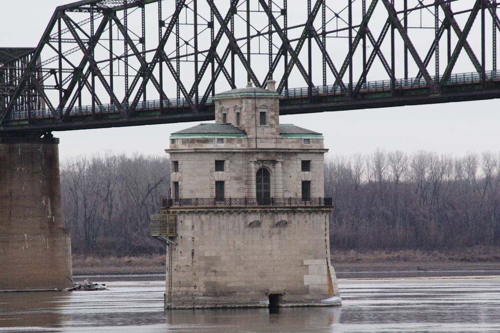
Chain of Rocks Water Intake Tower 1
Monument and historic site · 3.4 mi
Chain of Rocks Water Intake Tower 1 - still operating
Intake Water Tower #2
Monument and historic site · 3.4 mi
Chain of Rocks Water Intake Tower 2 - still operational as backup
Parks, trails and playgrounds21


Chain of Rocks Park
Park · 3.9 mi
Park in Missouri, United States of America, United States of America


Colonel George H. Blasé Park
Park · 4.2 mi
Municipal park in St. Louis, Missouri

9 more on the map.
Restaurants and cafes33






Domino's
Fast food · Pizza · 1.2 mi
3988 Maryville Road, Granite City
Mo-Th 10:30-24:00; Fr-Sa 10:30-01:00; Su 10:30-24:00
Domino's
Fast food · Pizza · 2.0 mi
2201 Madison Avenue, Granite City
Mo-Th 10:30-24:00; Fr-Sa 10:30-01:00; Su 10:30-24:00
21 more on the map.
Where to stay12
Super 8 by Wyndham Pontoon Beach IL/St. Louis MO Area
Motel and hotel · 3.1 mi
4141 Timberlake Drive, Pontoon Beach
Churches and places of worship48
Shopping6
Gas and EV charging9
Schools, colleges and libraries41
Healthcare2
McKinley Health Center
Clinic and pharmacy · 2.1 mi
2166 Madison Avenue, Granite City
Map of Granite City
190 places. The map loads OpenStreetMap tiles when you open it.
Climate by month
Monthly table
| Month | High | Low | Rain |
|---|---|---|---|
| Jan | 39°F | 22°F | 2.5 in |
| Feb | 44°F | 25°F | 2.5 in |
| Mar | 54°F | 35°F | 3.5 in |
| Apr | 66°F | 45°F | 4.9 in |
| May | 75°F | 56°F | 5.5 in |
| Jun | 84°F | 66°F | 3.4 in |
| Jul | 87°F | 69°F | 4.0 in |
| Aug | 86°F | 67°F | 3.3 in |
| Sep | 80°F | 60°F | 3.4 in |
| Oct | 68°F | 48°F | 2.9 in |
| Nov | 54°F | 36°F | 3.4 in |
| Dec | 44°F | 27°F | 2.6 in |
U.S. Climate Normals 1991-2020 for Alton - Melvin Price L&D (10 mi away), NOAA NCEI.
People and cost of living
American Community Survey 5-year estimates, 2020-2024, U.S. Census Bureau. Estimates have margins of error, larger for small towns.
Disaster history
Madison County has had 8 federal disaster declarations since 2000, most often for tornados.
- 2021-12-13: Severe Storms, Straight-Line Winds, And Tornadoes (Tornado)
- 2020-03-26: Covid-19 Pandemic (Biological)
- 2020-03-13: Covid-19 (Biological)
- 2019-09-19: Severe Storms And Flooding (Flood)
- 2008-06-24: Severe Storms And Flooding (Severe Storm)
- 2007-02-09: Severe Winter Storm (Severe Ice Storm)
OpenFEMA disaster declarations summaries.
Getting there and nearby towns
Saint Louis Downtown - Parks Airport (CPS) is the nearest airport with scheduled flights listed in OpenStreetMap, 11 miles away.
- Collinsville 7 mi southeast, about 12 min by car
- East St. Louis 8 mi south, about 13 min by car
- Glen Carbon 8 mi east, about 13 min by car
- St. Louis 9 mi southwest, about 15 min by car
- Edwardsville 9 mi northeast, about 14 min by car
- Cahokia Heights 11 mi south, about 18 min by car
- Fairview Heights 11 mi southeast, about 18 min by car
- Alton 12 mi north, about 20 min by car
- Belleville 16 mi southeast, about 26 min by car
- Columbia 19 mi south, about 31 min by car
Drive times are estimates from straight-line distance, not routes.
Local news
Headlines from INDB, the NEMICO news database.
Reviews, tips and questions
Loading what members have shared...
Sources and licences
- NCES EDGE (Public domain): public schools
- NOAA NCEI U.S. Climate Normals 1991-2020 (Public domain): climate by month
- OpenFEMA (Public domain): disaster declarations
- OpenStreetMap contributors (ODbL 1.0): places, airports, map data
- U.S. Census Bureau (Public domain): population, income, housing, education, commute
- Wikidata (CC0 1.0): elevation, founding date, time zone, website, landmarks and historic places
- Wikimedia Commons (see each image): photos
- Wikipedia (CC BY-SA 4.0): overview and history text
Photo credits
- Granite City - City Hall, Catching12 ( talk ), CC BY 3.0
- Horseshoe Lake Village, Nyttend, Public domain
- Mitchell Archaeological Site, Nyttend, Public domain
- Water Intake CoRB, Rklawton at English Wikipedia, CC BY-SA 3.0
- BisselHouse, Chuck Morris, CC BY-SA 3.0
- Wilson Larimore House 1985, National Park Service, U.S. Department of the Interior, Public domain
- Emmert-Zippel House, Nyttend, Public domain
- Granite City YMCA (34307718933), Paul Sableman, CC BY 2.0
- Cementland in 2015, Paul Sableman, CC BY 2.0
- Colonel George H. Blasé Park, Sesamehoneytart, CC BY-SA 4.0
- TheMerchantsBridge, Wilke339, CC0
- McKinley Bridge, LittleT889, CC BY-SA 4.0
- Camp Dubois reconstruction 034, Kbh3rd, CC BY-SA 3.0
- Chain of Rocks Bridges 1997, USGS, Public domain
Page built October 30, 2026. Spotted a mistake? Tell us or suggest a place.