


Grove City, Ohio
Grove City is a city of 42,517 people in Franklin County, Ohio, founded in 1852.
Why visit Grove City
Townapedia lists 7 museums and landmarks, 28 parks and trails, 99 places to eat, 21 places to stay and 2 attractions in and around town.
Highlights include AMC Grove City 14, Spangler Hill, A.G. Grant Homestead and Camp Chase.
July is the warmest month, with average highs of 86°F; January lows average 19°F.
Weather in Grove City
Forecast from the National Weather Service. Full forecast
About Grove City
Grove City is a city in Franklin County, Ohio, United States. The population was 41,252 as of the 2020 census, and was estimated at 45,180 in 2025.
From the Wikipedia article Grove City, Ohio (this version), under CC BY-SA 4.0.
Things to do2


Museums and landmarks7

A.G. Grant Homestead
Monument and historic site · National Register of Historic Places · 1.4 mi
Historic house in Ohio, United States
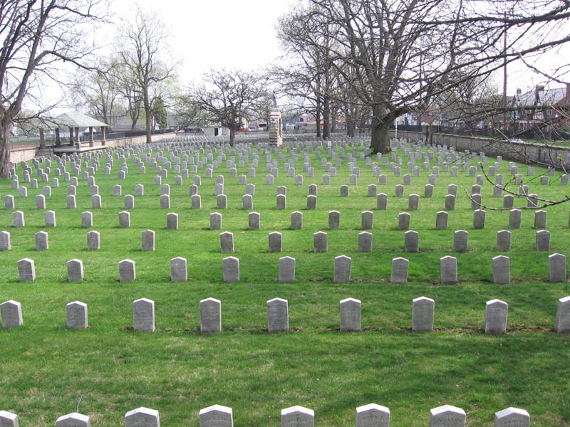
Camp Chase
Monument and historic site · National Register of Historic Places · 5.4 mi
Military camp in Columbus, Ohio, USA

Gantz Homestead
Monument and historic site · National Register of Historic Places · 2.2 mi
Historical farm house in Grove City, Ohio
Hartman Stock Farm Historic District
Monument and historic site · National Register of Historic Places · 3.5 mi
Historic district and farm in Columbus, Ohio


Samuel Landes House
Monument and historic site · National Register of Historic Places · 3.2 mi
Historic house in Columbus, Ohio, United States
Confederate Soldier Memorial
Monument and historic site · 5.4 mi
Monument in Columbus, Ohio, U.S.
Parks, trails and playgrounds28

Scioto Grove Metro Park
Park · 2.5 mi
Park and nature preserve in Grove City, Ohio, U.S


Creekside Park
Park · 0.5 mi
Park at he NW intersection of Autumn WInd Dr and Spring Morning Dr.
16 more on the map.
Restaurants and cafes99

Starbucks
Cafe · Coffee Shop · 1.7 mi
4144 Buckeye Parkway, Grove City
Su-Th 08:00-20:00; Fr,Sa 08:00-22:00

China Bell Restaurant
Restaurant · Chinese · 1.0 mi
1947 Stringtown Rd, Grove City
Su 11:00-21:00; Mo-Fr 11:00-22:00; Sa 12:00-22:00


87 more on the map.
History
The City of Grove City was founded in 1852. It was first incorporated as a village on March 5, 1866. Later, due to rapid growth, it was reincorporated and officially recognized as a city in 1959.
Until the mid-19th century, the area that is now Grove City was a wilderness filled with oak, beech, maple, walnut, dogwood and other trees. The area's first European settler, Hugh Grant, operated a gristmill in Pittsburgh and transported excess goods down the Ohio River for sale, returning to Pittsburgh on foot. On one of these trips, he passed through the Scioto Valley region and in 1803, purchased the land that would become Grove City and returned with his wife Catharine to start a new life.
Grove City's official founder, William F. Breck, bought 15.25 acres of the farm owned by Hugh Grant Jr., son of the first settler in Jackson Township, then added 300 more acres intended for farming. Breck's original plan changed when he realized the potential for growth since Harrisburg Turnpike passed through the area to the state capital, Columbus. Breck envisioned a new village complete with a school, church, stores, blacksmith and carpenter shops. Breck formed a commission with George Weygandt, William Sibray and Jeremiah Smith and platted the village on the east side of Broadway in 1852.
From the History section of Grove City, Ohio on Wikipedia, under CC BY-SA 4.0.
Where to stay21
Red Roof Inn Columbus/Grove City
Motel and hotel · 1.4 mi
4055 Jackpot Road, Grove City
Churches and places of worship23
Shopping17
Gas and EV charging19
Schools, colleges and libraries56
Healthcare9
Map of Grove City
250 places. The map loads OpenStreetMap tiles when you open it.
Climate by month
Monthly table
| Month | High | Low | Rain |
|---|---|---|---|
| Jan | 38°F | 19°F | 3.4 in |
| Feb | 43°F | 21°F | 2.6 in |
| Mar | 52°F | 30°F | 3.9 in |
| Apr | 65°F | 40°F | 4.0 in |
| May | 75°F | 51°F | 4.4 in |
| Jun | 83°F | 60°F | 3.9 in |
| Jul | 86°F | 64°F | 4.6 in |
| Aug | 85°F | 61°F | 3.6 in |
| Sep | 80°F | 54°F | 3.6 in |
| Oct | 68°F | 42°F | 2.9 in |
| Nov | 54°F | 32°F | 3.0 in |
| Dec | 43°F | 25°F | 3.4 in |
U.S. Climate Normals 1991-2020 for Columbus-Valley Crossing (8 mi away), NOAA NCEI.
People and cost of living
American Community Survey 5-year estimates, 2020-2024, U.S. Census Bureau. Estimates have margins of error, larger for small towns.
Disaster history
Franklin County has had 15 federal disaster declarations since 2000, most often for severe storms.
- 2026-10-02: Severe Storms, Straight-Line Winds, Tornadoes, Flooding, And Landslides (Flood)
- 2020-03-31: Covid-19 Pandemic (Biological)
- 2020-03-13: Covid-19 (Biological)
- 2012-08-20: Severe Storms And Straight-Line Winds (Severe Storm)
- 2012-06-30: Severe Storms (Severe Storm)
- 2008-10-24: Severe Wind Storm Associated With Tropical Depression Ike (Severe Storm)
OpenFEMA disaster declarations summaries.
Getting there and nearby towns
Millertime Airport (4OH4) is the nearest airport with scheduled flights listed in OpenStreetMap, 6 miles away.
- Columbus 9 mi northeast, about 15 min by car
- Bexley 10 mi northeast, about 16 min by car
- Upper Arlington 11 mi north, about 18 min by car
- Whitehall 12 mi northeast, about 19 min by car
- Hilliard 13 mi north, about 20 min by car
- Canal Winchester 14 mi east, about 22 min by car
- Gahanna 15 mi northeast, about 25 min by car
- Reynoldsburg 16 mi northeast, about 26 min by car
- Pickerington 16 mi east, about 26 min by car
- Worthington 16 mi north, about 26 min by car
Drive times are estimates from straight-line distance, not routes.
Local news
Headlines from INDB, the NEMICO news database.
Reviews, tips and questions
Loading what members have shared...
Sources and licences
- NCES EDGE (Public domain): public schools
- NOAA NCEI U.S. Climate Normals 1991-2020 (Public domain): climate by month
- OpenFEMA (Public domain): disaster declarations
- OpenStreetMap contributors (ODbL 1.0): places, airports, map data
- U.S. Census Bureau (Public domain): population, income, housing, education, commute
- Wikidata (CC0 1.0): elevation, founding date, time zone, website, landmarks and historic places
- Wikimedia Commons (see each image): photos
- Wikipedia (CC BY-SA 4.0): overview and history text
Photo credits
- Grove city gantz homestead, Wdzinc, CC BY-SA 3.0
- Waterbeds 'n' Stuff Corporate Office Furniture Warehouse Interior, Grove City, Ohio, WaterbedsRobbie, CC BY-SA 4.0
- Waterbeds 'n' Stuff Corporate Office Exterior, Grove City, Ohio, WaterbedsRobbie, CC BY-SA 4.0
- Grove City Police Memorial 1, Sixflashphoto, CC BY-SA 4.0
- Grove City Municipal Safety Complex 1, Sixflashphoto, CC BY-SA 4.0
- Grove City - Gold Star Memorial Monument 1, Sixflashphoto, CC BY-SA 4.0
- Grove City Government Offices 1, Sixflashphoto, CC BY-SA 4.0
- Grove City Library 1, Sixflashphoto, CC BY-SA 4.0
- Swan Cleaners hot air balloon over Grove City, Ohio in 2009, Nahida, CC BY-SA 4.0
- Our Lady of Perpetual Help Catholic Church (Grove City, Ohio) - exterior 2, Nheyob, CC BY-SA 4.0
- Our Lady of Perpetual Help Catholic Church (Grove City, Ohio) - Blessed Virgin Mary statue, Nheyob, CC BY-SA 4.0
- Our Lady of Perpetual Help Catholic Church (Grove City, Ohio) - exterior, Nheyob, CC BY-SA 4.0
- OhioHealth Grove City Medical Center Under Construction 1, Sixflashphoto, CC BY-SA 4.0
- Grove city ag grant homestead, Wdzinc, CC BY-SA 3.0
- Camp chase 1, User Georgeccampbell on en.wikipedia, Public domain
- Samuel Landes House, Ɱ, CC BY-SA 4.0
- Jackson Township Administration Building 1, Sixflashphoto, CC BY-SA 4.0
- Jackson Township Fire Department 1, Sixflashphoto, CC BY-SA 4.0
- Jackson Township Fire Department 2, Sixflashphoto, CC BY-SA 4.0
- Scioto Grove Metro Park - 43185506964, dankeck, CC0
- UrbanCrest Maintenance Facilities 1, Sixflashphoto, CC BY-SA 4.0
- Scioto Grove - Wetlands at Entrance 1, Sixflashphoto, CC BY-SA 4.0
- Scioto Grove Metro Park - 30034296258, dankeck, CC0
- Scioto Grove - Reforestation Area 1, Sixflashphoto, CC BY-SA 4.0
- Central Avenue houses in Urbancrest, Nyttend, Public domain
- Scioto Grove - Hickory Picnic Area 1, Sixflashphoto, CC BY-SA 4.0
- Scioto Grove - Hickory Picnic Area 2, Sixflashphoto, CC BY-SA 4.0
- Scioto Grove Metro Park - 43185395164, dankeck, CC0
- Scioto Grove Metro Park - 43185395394, dankeck, CC0
- Scioto Grove Metro Park - 30034292868, dankeck, CC0
- Scioto Grove Metro Park - 30034288378, dankeck, CC0
- Scioto Grove - Drone Flight Field 1, Sixflashphoto, CC BY-SA 4.0
- Scioto Grove Metro Park - 43185396734, dankeck, CC0
- Scioto Grove Metro Park - 42094697890, dankeck, CC0
- Scioto Grove Metro Park - 42094697680, dankeck, CC0


Page built October 30, 2026. Spotted a mistake? Tell us or suggest a place.