


Why visit Hagaman
Townapedia lists 17 museums and landmarks, 2 parks and trails, 23 places to eat and 1 attraction in and around town.
Highlights include Mohawk Valley Gateway Overlook pedestrian bridge, Amsterdam Castle and Chalmers Knitting Mills.
July is the warmest month, with average highs of 82°F; January lows average 12°F.
Weather in Hagaman
Forecast from the National Weather Service. Full forecast
About Hagaman
Hagaman (), formerly Hagamans Mills, is a village in Montgomery County, New York, United States. The population was 1,117 at the 2020 census, down from 1,292 in 2010. It is named after Joseph Hagaman, the founding father.
From the Wikipedia article Hagaman, New York (this version), under CC BY-SA 4.0.
Things to do1

Mohawk Valley Gateway Overlook pedestrian bridge
Bridge · 3.0 mi
Pedestrian bridge in Amsterdam, New York
Museums and landmarks17
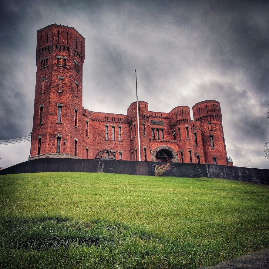
Amsterdam Castle
Monument and historic site · National Register of Historic Places · 3.3 mi
United States historic place in Amsterdam, New York

Chalmers Knitting Mills
Monument and historic site · National Register of Historic Places · 3.1 mi
Historic factory in New York, United States

Gray-Jewett House
Monument and historic site · National Register of Historic Places · 3.3 mi
Historic house in New York, United States

Green Hill Cemetery
Monument and historic site · National Register of Historic Places · 2.6 mi
Cemetery in Amsterdam, New York

Greene Mansion
Monument and historic site · National Register of Historic Places · 2.6 mi
Historic house in Amsterdam, New York, United States
Guy Park
Monument and historic site · National Register of Historic Places · 3.0 mi
Historic house in New York, United States

Guy Park Avenue School
Monument and historic site · National Register of Historic Places · 2.9 mi
School building in New York, United States of America
Hurricana Stock Farm
Monument and historic site · National Register of Historic Places · 1.6 mi
Historic home and related farm outbuildings located at Amsterdam in Montgomery County, New York
Pawling Hall
Monument and historic site · National Register of Historic Places · 0.6 mi
Historic meeting hall in Hagaman, Montgomery County, New York, United States

Saint Stanislaus Roman Catholic Church Complex
Monument and historic site · National Register of Historic Places · 2.2 mi
Roman Catholic church complex in New York
Samuel and Johanna Jones Farm
Monument and historic site · National Register of Historic Places · 2.7 mi
Building in New York, United States


Samuel Sweet Canal Store
Monument and historic site · National Register of Historic Places · 3.2 mi
Historic commercial building in New York, United States
5 more on the map.
Parks, trails and playgrounds2


Restaurants and cafes23

CP's Family Restaurant
Diner · American · 0.6 mi
17 Main Street, Hagaman
Tu-Sa 11:30-20:30, Su 11:30-18:30, Mo closed
Ruby Tuesday
Diner · American · 1.4 mi
4917 State Highway 30, Amsterdam

Amsterdam Diner
Restaurant · Diner, American, Regional · 1.5 mi
4790 Perth Road, Amsterdam


11 more on the map.
History
The community was formerly called "Hagamans Mills". It was founded circa 1777. Village offices are located in the historic Pawling Hall, listed on the National Register of Historic Places in 2002.
From the History section of Hagaman, New York on Wikipedia, under CC BY-SA 4.0.
Churches and places of worship1
Saint Stephen Catholic Church
Church · Roman Catholic · 0.8 mi
51 North Pawling Street, Hagaman
Shopping8
Gas and EV charging1
Schools, colleges and libraries9
Broadalbin-Perth Elementary School
School · 3.6 mi
1870 County Hwy 107, Amsterdam
Broadalbin-Perth Junior-Senior High School
School · 6.0 mi
100 Bridge St, Broadalbin
Marie Curie Institute of Engineering And Communication
School · 2.2 mi
9 Brice St, Amsterdam
Raphael J Mcnulty Academy For Intern Studies & Literacy
School · 2.4 mi
60 Brandt Pl, Amsterdam
William B. Tecler Arts in Education Magnet School
School · 1.0 mi
210 Northern Boulevard, Amsterdam
Healthcare2
Amsterdam Family Practice
Clinic and pharmacy · 1.5 mi
119 Holland Circle Drive, Amsterdam
Map of Hagaman
64 places. The map loads OpenStreetMap tiles when you open it.
Climate by month
Monthly table
| Month | High | Low | Rain |
|---|---|---|---|
| Jan | 31°F | 12°F | 2.6 in |
| Feb | 34°F | 13°F | 2.4 in |
| Mar | 42°F | 20°F | 3.3 in |
| Apr | 57°F | 33°F | 3.4 in |
| May | 70°F | 44°F | 3.5 in |
| Jun | 77°F | 54°F | 5.0 in |
| Jul | 82°F | 59°F | 4.5 in |
| Aug | 80°F | 56°F | 4.1 in |
| Sep | 74°F | 48°F | 3.6 in |
| Oct | 59°F | 38°F | 4.5 in |
| Nov | 48°F | 28°F | 2.8 in |
| Dec | 36°F | 19°F | 3.0 in |
U.S. Climate Normals 1991-2020 for Delanson 2Ne (14 mi away), NOAA NCEI.
People and cost of living
American Community Survey 5-year estimates, 2020-2024, U.S. Census Bureau. Estimates have margins of error, larger for small towns.
Disaster history
Montgomery County has had 22 federal disaster declarations since 2000, most often for severe storms.
- 2021-08-22: Hurricane Henri (Hurricane)
- 2020-03-20: Covid-19 Pandemic (Biological)
- 2020-03-13: Covid-19 (Biological)
- 2019-12-19: Severe Storms, Straight-Line Winds, And Flooding (Severe Storm)
- 2017-07-12: Severe Winter Storm And Snowstorm (Snowstorm)
- 2013-07-12: Severe Storms And Flooding (Flood)
OpenFEMA disaster declarations summaries.
Getting there and nearby towns
Schenectady County Airport (SCH) is the nearest airport with scheduled flights listed in OpenStreetMap, 14 miles away.
- Amsterdam 3 mi southwest, about 4 min by car
- Broadalbin 6 mi north, about 10 min by car
- Gloversville 11 mi northwest, about 17 min by car
- East Glenville 14 mi southeast, about 22 min by car
- Schenectady 17 mi southeast, about 27 min by car
- Rotterdam 17 mi southeast, about 27 min by car
- Niskayuna 18 mi southeast, about 29 min by car
- Altamont 19 mi south, about 31 min by car
- Saratoga Springs 20 mi east, about 33 min by car
- Canajoharie 21 mi west, about 34 min by car
Drive times are estimates from straight-line distance, not routes.
Local news
Headlines from INDB, the NEMICO news database.
Reviews, tips and questions
Loading what members have shared...
Sources and licences
- NCES EDGE (Public domain): public schools
- NOAA NCEI U.S. Climate Normals 1991-2020 (Public domain): climate by month
- OpenFEMA (Public domain): disaster declarations
- OpenStreetMap contributors (ODbL 1.0): places, airports, map data
- U.S. Census Bureau (Public domain): population, income, housing, education, commute
- Wikidata (CC0 1.0): elevation, founding date, time zone, website, landmarks and historic places
- Wikimedia Commons (see each image): photos
- Wikipedia (CC BY-SA 4.0): overview and history text
Photo credits
- Temple of Israel Amsterdam NY Apr 11, Doug Kerr, CC BY-SA 2.0
- Old Guy Park House, Amsterdam, NY, Unknown photographer, Public domain
- Chalmers Knitting Mills Amsterdam NY Jul 09, Doug Kerr, CC BY-SA 2.0
- Saint Stanislaus Roman Catholic Church Amsterdam NY Apr 11, Doug Kerr, CC BY-SA 2.0
- Amsterdam Post Office, Jess Mann, CC BY-SA 4.0
- Gray-Jewett House, Amsterdam from front, Beyond My Ken, CC BY-SA 4.0
- New York - Guy Park Avenue School - 20190930135647, Jess, CC BY-SA 4.0
- Amsterdam Armory - Stormy, Jess Mann, CC BY-SA 4.0
- Samuel Sweet Canal Store, Amsterdam, Beyond My Ken, CC BY-SA 4.0
- House in Amsterdam, NY, Kristin, CC BY 2.0
- New York - Vrooman Avenue School - 20190930162336, Jess, CC BY-SA 4.0
- Mohawk Valley Gateway Overlook pedestrian bridge, Timothy Becker, CC BY-SA 4.0

Page built October 30, 2026. Spotted a mistake? Tell us or suggest a place.