



Haltom City, Texas
Haltom City is a city of 45,767 people in Tarrant County, Texas, founded in 1932.
Why visit Haltom City
Townapedia lists 23 museums and landmarks, 26 parks and trails, 90 places to eat, 26 places to stay and 2 attractions in and around town.
Highlights include Farmers Market Fort Worth, American Airways Hangar and Administration Building, Oakhurst Historic District and Buffalo Ridge Park.
July is the warmest month, with average highs of 94°F; January lows average 36°F.
Weather in Haltom City
Forecast from the National Weather Service. Full forecast
About Haltom City
Haltom City is a city in the U.S. state of Texas, located in Tarrant County. It is part of the Mid-Cities region of the Dallas–Fort Worth Metroplex. Its population was 46,073 at the 2020 census. Haltom City is an inner suburb of Fort Worth, a principal city of the DFW Metroplex.
From the Wikipedia article Haltom City, Texas (this version), under CC BY-SA 4.0.
Things to do2

Farmers Market Fort Worth
Farm and orchard · 1.3 mi
5507 Belknap Street
Mo-Fr 08:00-17:30; Sa 08:00-17:00

Museums and landmarks23
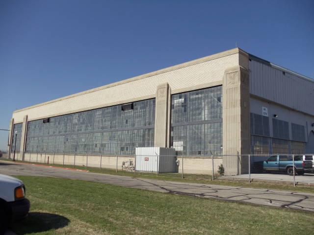
American Airways Hangar and Administration Building
Monument and historic site · National Register of Historic Places · 4.9 mi
Building in Fort Worth (vicinity), Tarrant County, Texas


Oakhurst Historic District
Monument and historic site · National Register of Historic Places · 3.3 mi
Historic district in Fort Worth, Tarrant County, Texas


Amon Carter Riverside High School and Riverside ISD
Monument and historic site · 3.0 mi
11 more on the map.
Parks, trails and playgrounds26

Buffalo Ridge Park
Park · 2.4 mi
Large park with 3 miles of trails, a playground, pavilion, and other amenities on 95 acres.
5720 Parkwood Trail, Haltom City

Little Fossil Park
Park · 1.0 mi
Neighborhood park, renovated in 2014 with 3 softball fields
4412 Hadley Street, Haltom City
Haltom Road Park
Park · 0.9 mi
9 acre neighborhood park
3113 Haltom Road, Haltom City
North Park
Park · 1.8 mi
46 acre community park shared by Haltom City and the Northeast Optimist Club
5220 Denton Highway, Haltom City
14 more on the map.
Restaurants and cafes90


Jason's Deli
Restaurant · Sandwich · 2.5 mi
5131 Rufe Snow Drive, North Richland Hills
Mo-Sa 06:30-22:00; Su off

Starbucks
Cafe · Coffee Shop · 2.6 mi
5162 Rufe Snow Drive, North Richland Hills
Mo-Th,Su 05:00-22:00; Fr 04:30-22:30; Sa 05:00-22:30

Las Delicias De Michoacan
Ice cream · 2.8 mi
5340 Rufe Snow Drive, North Richland Hills
Mo-Su 12:00-22:00

My Stomping Grounds
Bar and pub · 1.4 mi
5130 Northern Cross Boulevard, Haltom City
Su-Th 11:00-24:00; Fr,Sa 11:00-26:00
Cafe BomBom & XO Corndog
Restaurant · Korean · 1.8 mi
3490 Northeast Loop 820
Su-Th 11:00-20:30; Fr-Sa 11:00-21:00
Clown Burger
Restaurant · Burger · 0.4 mi
5020 Stanley Keller Road
Mo-Th 11:00-17:00; Fr-Sa 11:00-19:00
Phở Nam
Restaurant · Vietnamese, Noodle · 2.5 mi
4045, Suite 1 East Belknap Street
Su-We 09:00-20:00; Fr-Sa 09:00-21:00
78 more on the map.
Where to stay26
Days Inn by Wyndham Fort Worth North / Fossil Creek
Motel and hotel · 2.6 mi
4681 Gemini Place, Fort Worth
Hampton Inn & Suites Fort Worth Fossil Creek
Motel and hotel · 2.4 mi
3850 Sandshell Drive, Fort Worth
Home2 Suites by Hilton Fort Worth Fossil Creek
Motel and hotel · 1.8 mi
5100 Endicott Avenue, Fort Worth
Radisson Hotel Fort Worth North-Fossil Creek
Motel and hotel · 2.6 mi
2540 Meacham Boulevard, Fort Worth
Fairfield Inn & Suites Fort Worth/Fossil Creek
Motel and hotel · 2.1 mi
3751 Northeast Loop 820, Fort Worth
Churches and places of worship61
Calvary Chapel of Fort Worth Church
Church · Nondenominational · 0.5 mi
5617 Diamond Oaks Drive South, Haltom City
Saint Luke United Methodist Church
Church · United Methodist · 0.9 mi
3200 Denton Highway, Haltom City
Christ the King Catholic Church;Giáo Xứ Chúa Kitô Vua
Church · Roman Catholic · 3.0 mi
1120 Eagle Drive
City Point United Methodist Church;Duncan Family Life Center
Church · United Methodist · 2.9 mi
7301 Glenview Drive, North Richland Hills
Nguyện Đường Nữ Vương Các Thánh Tử Đạo Việt Nam
Church · Roman Catholic · 3.0 mi
1120 Eagle Drive
The Hills Church
Church · Church Of Christ · 1.9 mi
6300 NE Loop 820, North Richland Hills
Shopping13
Gas and EV charging31
Schools, colleges and libraries70
Richland High School
School · 2.9 mi
5201 Holiday Lane East, North Richland Hills
Academy At Carrie F Thomas
School · 4.4 mi
8200 O Brian Way, North Richland Hills
Healthcare10
Sam's Club Pharmacy
Clinic and pharmacy · 2.2 mi
6375 Northeast Loop 820, North Richland Hills
Savon Pharmacy
Clinic and pharmacy · 3.1 mi
4400 Western Center Boulevard, Fort Worth
Walmart Pharmacy
Clinic and pharmacy · 2.2 mi
6401 Northeast Loop 820, North Richland Hills
Passport Health Haltom City Travel Clinic
Clinic and pharmacy · 2.4 mi
5208 Airport Freeway, Fort Worth
Cook Children's Neighborhood Clinic - Richland Hills
Clinic and pharmacy · 2.5 mi
Map of Haltom City
250 places. The map loads OpenStreetMap tiles when you open it.
Climate by month
Monthly table
| Month | High | Low | Rain | Snow |
|---|---|---|---|---|
| Jan | 56°F | 36°F | 2.2 in | 0.1 in |
| Feb | 59°F | 39°F | 2.6 in | 1.3 in |
| Mar | 67°F | 47°F | 3.2 in | 0.3 in |
| Apr | 75°F | 54°F | 3.2 in | 0.0 in |
| May | 82°F | 64°F | 4.3 in | 0.0 in |
| Jun | 90°F | 71°F | 4.3 in | 0.0 in |
| Jul | 94°F | 75°F | 2.8 in | 0.0 in |
| Aug | 94°F | 75°F | 2.5 in | 0.0 in |
| Sep | 87°F | 68°F | 2.7 in | 0.0 in |
| Oct | 77°F | 56°F | 4.6 in | 0.0 in |
| Nov | 65°F | 45°F | 2.6 in | 0.0 in |
| Dec | 57°F | 37°F | 2.9 in | 0.3 in |
U.S. Climate Normals 1991-2020 for Ft Worth Wsfo 72249 (2 mi away), NOAA NCEI.
People and cost of living
American Community Survey 5-year estimates, 2020-2024, U.S. Census Bureau. Estimates have margins of error, larger for small towns.
Disaster history
Tarrant County has had 19 federal disaster declarations since 2000, most often for hurricanes.
- 2021-02-19: Severe Winter Storms (Severe Ice Storm)
- 2021-02-14: Severe Winter Storm (Severe Ice Storm)
- 2020-08-24: Tropical Storms Marco And Laura (Hurricane)
- 2020-03-25: Covid-19 Pandemic (Biological)
- 2020-03-13: Covid-19 (Biological)
- 2017-08-25: Hurricane Harvey (Hurricane)
OpenFEMA disaster declarations summaries.
Getting there and nearby towns
Fort Worth Meacham International Airport (FTW) is the nearest airport with scheduled flights listed in OpenStreetMap, 5 miles away.
- Fort Worth 5 mi southwest, about 8 min by car
- Bedford 8 mi east, about 13 min by car
- Colleyville 9 mi northeast, about 14 min by car
- Euless 11 mi east, about 18 min by car
- Forest Hill 11 mi south, about 17 min by car
- Arlington 12 mi southeast, about 19 min by car
- Benbrook 15 mi southwest, about 24 min by car
- Grand Prairie 17 mi southeast, about 28 min by car
- Irving 18 mi east, about 29 min by car
- Flower Mound 18 mi northeast, about 29 min by car
Drive times are estimates from straight-line distance, not routes.
Local news
Headlines from INDB, the NEMICO news database.
Reviews, tips and questions
Loading what members have shared...
Sources and licences
- NCES EDGE (Public domain): public schools
- NOAA NCEI U.S. Climate Normals 1991-2020 (Public domain): climate by month
- OpenFEMA (Public domain): disaster declarations
- OpenStreetMap contributors (ODbL 1.0): places, airports, map data
- U.S. Census Bureau (Public domain): population, income, housing, education, commute
- Wikidata (CC0 1.0): elevation, founding date, time zone, website, landmarks and historic places
- Wikimedia Commons (see each image): photos
- Wikipedia (CC BY-SA 4.0): overview and history text
Photo credits
- Haltom Road, Non-dropframe, CC BY-SA 3.0
- American Airlines Hangar Fort Worth, Renelibrary, CC BY-SA 3.0
- Oakhurst Historic District, Renelibrary, CC BY-SA 3.0
- MVI 2986 Texas Cowboy Hall of Fame in Fort Worth, Billy Hathorn, CC BY-SA 3.0
- ISS020-E-33229 - View of Earth, Earth Science and Remote Sensing Unit , Lyndon B. Johnson Space Center, Public domain
- ISS020-E-33228 - View of Earth, Earth Science and Remote Sensing Unit , Lyndon B. Johnson Space Center, Public domain
- ISS040-E-102268 - View of Earth, Earth Science and Remote Sensing Unit , Lyndon B. Johnson Space Center, Public domain
- ISS016-E-23052 - View of Earth, Earth Science and Remote Sensing Unit , Lyndon B. Johnson Space Center, Public domain
- Hackberry Thorn Galls, Sam Kieschnick, CC BY 4.0
- Elton John & Bernie Taupin - Tumbleweed Connection; Original Framed Platinum 33 1-3 Record., Cadejacksoncampbell, CC BY-SA 4.0
- Mount Olivet Cemetery Gate, Mount Olivet Cemetery, Public domain
- Mount Olivet Receiving Vault, Mount Olivet Cemetery, Public domain
- April 2022 FWWR RR diesels, Fort Worth, Texas, David Wilson, CC BY 2.0
- Valero-Cornerstore HCTX, Smarty9108, CC BY-SA 4.0


Page built October 30, 2026. Spotted a mistake? Tell us or suggest a place.