


Hanscom AFB, Massachusetts
Hanscom AFB is a community of 2,110 people in Middlesex County, Massachusetts.
Why visit Hanscom AFB
Townapedia lists 57 museums and landmarks, 25 parks and trails, 3 places to eat, 3 places to stay and 7 attractions in and around town.
Highlights include Cranberry Hill, Fiske Hill, Bacon-Gleason-Blodgett Homestead and Bedford Center Historic District.
July is the warmest month, with average highs of 85°F; January lows average 18°F.
Weather in Hanscom AFB
Forecast from the National Weather Service. Full forecast
Things to do7

Museums and landmarks57

Bacon-Gleason-Blodgett Homestead
Monument and historic site · National Register of Historic Places · 3.3 mi
Building in Massachusetts, United States

Bedford Center Historic District
Monument and historic site · National Register of Historic Places · 2.4 mi
Historic district in Bedford, MA

Bedford Depot
Monument and historic site · National Register of Historic Places · 1.9 mi
Railway station in Bedford, the United States of America

Bedford Veterans Affairs Medical Center
Monument and historic site · National Register of Historic Places · 3.3 mi
Hospital in Massachusetts, United States

Buckman Tavern
Monument and historic site · National Register of Historic Places · 2.6 mi
American Revolutionary War site, Lexington, Massachusetts

Christopher Page House
Monument and historic site · National Register of Historic Places · 2.8 mi
Building in Massachusetts, United States
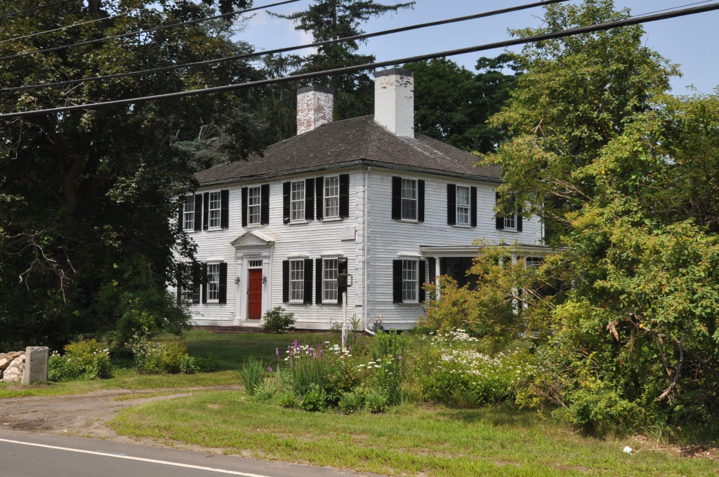
Colonel Timothy Jones House
Monument and historic site · National Register of Historic Places · 2.1 mi
Historic house in Massachusetts, United States

Daniel Brooks House
Monument and historic site · National Register of Historic Places · 1.7 mi
Building in Massachusetts, United States

David Lane House
Monument and historic site · National Register of Historic Places · 3.1 mi
Building in Massachusetts, United States

Flint House
Monument and historic site · National Register of Historic Places · 2.2 mi
Building in Massachusetts, United States

Franklin School
Monument and historic site · National Register of Historic Places · 3.2 mi
Historic building in Lexington, Massachusetts, United States

Gen. Samuel Chandler House
Monument and historic site · National Register of Historic Places · 2.6 mi
Historic house in Massachusetts, United States
45 more on the map.
Parks, trails and playgrounds25


Mystic River Reservation
Park · 3.3 mi
Nature reserve in Massachusetts, United States of America




13 more on the map.
Restaurants and cafes3



Where to stay3
Shopping2
Gas and EV charging1
Schools, colleges and libraries43
Minuteman Regional Vocational Technical High School
School · 0.9 mi
758 Marrett Road, Lexington
Healthcare2
Map of Hanscom AFB
143 places. The map loads OpenStreetMap tiles when you open it.
Climate by month
Monthly table
| Month | High | Low | Rain |
|---|---|---|---|
| Jan | 37°F | 18°F | 2.9 in |
| Feb | 39°F | 19°F | 2.7 in |
| Mar | 48°F | 27°F | 3.9 in |
| Apr | 60°F | 37°F | 3.8 in |
| May | 70°F | 47°F | 3.4 in |
| Jun | 79°F | 56°F | 3.7 in |
| Jul | 85°F | 62°F | 3.5 in |
| Aug | 84°F | 60°F | 3.5 in |
| Sep | 76°F | 52°F | 3.5 in |
| Oct | 64°F | 41°F | 4.2 in |
| Nov | 52°F | 32°F | 3.7 in |
| Dec | 42°F | 24°F | 3.8 in |
U.S. Climate Normals 1991-2020 for Bedford Hanscom Fld 74490 (1 mi away), NOAA NCEI.
People and cost of living
American Community Survey 5-year estimates, 2020-2024, U.S. Census Bureau. Estimates have margins of error, larger for small towns.
Disaster history
Middlesex County has had 26 federal disaster declarations since 2000, most often for severe storms.
- 2023-09-15: Hurricane Lee (Hurricane)
- 2020-03-27: Covid-19 Pandemic (Biological)
- 2020-03-13: Covid-19 (Biological)
- 2018-07-19: Severe Winter Storm And Snowstorm (Snowstorm)
- 2015-04-13: Severe Winter Storm, Snowstorm, And Flooding (Severe Storm)
- 2013-04-19: Severe Winter Storm, Snowstorm, And Flooding (Severe Storm)
OpenFEMA disaster declarations summaries.
Getting there and nearby towns
Laurence G. Hanscom Field (BED) is the nearest airport with scheduled flights listed in OpenStreetMap, 1 miles away.
- Lexington 3 mi east, about 4 min by car
- Waltham 5 mi south, about 8 min by car
- Burlington 5 mi northeast, about 8 min by car
- Pinehurst 6 mi northeast, about 9 min by car
- Arlington 6 mi southeast, about 10 min by car
- West Concord 6 mi west, about 10 min by car
- Woburn 7 mi east, about 11 min by car
- Belmont 7 mi southeast, about 11 min by car
- Winchester 7 mi east, about 11 min by car
- Watertown 8 mi southeast, about 13 min by car
Drive times are estimates from straight-line distance, not routes.
Local news
Headlines from INDB, the NEMICO news database.
Reviews, tips and questions
Loading what members have shared...
Sources and licences
- NCES EDGE (Public domain): public schools
- NOAA NCEI U.S. Climate Normals 1991-2020 (Public domain): climate by month
- OpenFEMA (Public domain): disaster declarations
- OpenStreetMap contributors (ODbL 1.0): places, airports, map data
- U.S. Census Bureau (Public domain): population, income, housing, education, commute
- Wikidata (CC0 1.0): landmarks and historic places
- Wikimedia Commons (see each image): photos
Photo credits
- Bacon-Gleason-Blodgett Homestead, Bedford MA, John Phelan, CC BY 3.0
- Lexington Battle Green, Lexington MA, John Phelan, CC BY 3.0
- Bedford Depot Park, Tim Pierce, Public domain
- The Wayside Concord Massachusetts, Daderot at English Wikipedia, CC BY-SA 3.0
- David Lane House, Bedford MA, John Phelan, CC BY 3.0
- Unitarian Meeting House (exterior) Bedford, Massachusetts, Daderot at en.wikipedia, CC BY-SA 3.0
- Hancock School, May 2012, Lexington MA, John Phelan, CC BY-SA 3.0
- Hancock-Clarke House Lexington Massachusetts, Original uploader was Daderot at en.wikipedia, CC BY-SA 3.0
- Wheeler-Minot Farmhouse, Concord MA, John Phelan, CC BY 3.0
- BedfordMA JonesHouse, Magicpiano, CC BY-SA 4.0
- North view of the Hoar Homestead, Lincoln MA, John Phelan, CC BY 3.0
- Buckman Tavern 1, Bostonian13, CC BY-SA 3.0
- Minute Man National Historical Park MIMA2669, National Park Service Digital Image Archives, Public domain
- First Parish in Lincoln, MA, John Phelan, CC BY 3.0
- Shawsheen Cemetery, October 2013, Bedford MA, John Phelan, CC BY-SA 3.0
- LexingtonMA MHMerriamAndCompany, User:Magicpiano, CC BY-SA 4.0
- Building 2, VA Medical Center, Bedford MA, John Phelan, CC BY-SA 3.0
- Ralph Waldo Emerson House (Concord, MA), Daderot., CC BY-SA 3.0
- Warren E. Sherburne House, Lexington MA, John Phelan, CC BY 3.0
- Old Burlington Road Bridge over Vine Brook, Bedford MA, John Phelan, CC BY-SA 4.0
- Nathaniel Page House, Bedford MA, John Phelan, CC BY 3.0
- Daniel Brooks House, Lincoln MA, John Phelan, CC BY 3.0
- General Samuel Chandler House, Lexington MA, John Phelan, CC BY 3.0
- Simonds Tavern, April 2010, Lexington MA, John Phelan, CC BY 3.0
- Henry Higginson House, Lincoln MA, John Phelan, CC BY 3.0
- Flint House, Lincoln MA, John Phelan, CC BY 3.0
- US Post Office, Lexington MA, John Phelan, CC BY 3.0
- 5 Woods End, Lincoln MA, John Phelan, CC BY 3.0
- LexingtonMA FranklinSchool, User:Magicpiano, CC BY-SA 4.0
- Gropius House, Lincoln, Massachusetts - Front View, The original uploader was Daderot at English Wikipedia ., CC BY-SA 3.0
- Christopher Page House, Bedford MA, John Phelan, CC BY 3.0
- Orchard House from Little Women, User:victorgrigas, CC BY-SA 3.0
- Wheeler-Merriam House, Concord MA, John Phelan, CC BY 3.0
- ArlingtonMA MysticParkway, User:Magicpiano, CC BY-SA 4.0
- DeCordova 01, Jeff Egnaczyk from Brookline, MA, CC BY 2.0
- Museo Concord, openroads.com, CC BY 2.0
- Child drawing, D. Sharon Pruitt from Hill Air Force Base, Utah, USA, CC BY 2.0
- The Skate Park Shadows, D. Sharon Pruitt from Hill Air Force Base, Utah, USA, CC BY 2.0
- Little girl buried up to her neck in sand, D. Sharon Pruitt from Hill Air Force Base, Utah, USA, CC BY 2.0
- Love Shines Through The Darkness free creative commons (1535763813), Pink Sherbet Photography from USA, CC BY 2.0


Page built October 30, 2026. Spotted a mistake? Tell us or suggest a place.