


Why visit Hayden
Townapedia lists 6 museums and landmarks, 17 parks and trails, 73 places to eat, 3 places to stay and 3 attractions in and around town.
Highlights include Hayden Discount Cinema, Clark House, John A. Finch Caretaker's House and Avondale Golf Club.
August is the warmest month, with average highs of 83°F; January lows average 26°F.
Weather in Hayden
Forecast from the National Weather Service. Full forecast
About Hayden
Hayden is a city in Kootenai County, Idaho, United States. Located in the northern portion of the state, it is a suburb of nearby Coeur d'Alene and its population was 15,570 at the 2020 census.
From the Wikipedia article Hayden, Idaho (this version), under CC BY-SA 4.0.
Things to do3



Museums and landmarks6
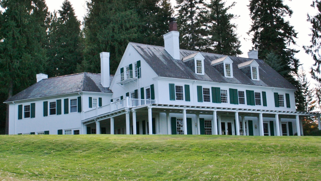
Clark House
Monument and historic site · National Register of Historic Places · 3.6 mi
Single-family detached home in Kootenai County, United States of America


John A. Finch Caretaker's House
Monument and historic site · National Register of Historic Places · 2.2 mi
Historic house in Hayden Lake, Idaho


Parks, trails and playgrounds17


5 more on the map.
Restaurants and cafes73

Applebee's
Diner · American · 2.7 mi
280 West Hanley Avenue, Coeur d’Alene
Mo-Th 11:00-00:00, Fr-Sa 11:00-01:00, Su 11:00-00:00

Capone's Pub & Grill
Restaurant · American, Burger, Pizza, Sandwich · 1.0 mi
9520 North Government Way, Hayden
Mo-We 11:00-21:00, Th-Sa 11:00-22:00, Su 09:30-21:00
Rustler's Roost
Restaurant · Breakfast · 0.7 mi
9757 North Rustlers Trail, Hayden
Mo 07:00-14:00,Th-Su 07:00-14:00


32 Below Frozen Yogurt & More
Ice cream · Frozen Yogurt · 2.6 mi
Su-Th 10:00-21:00; Fr-Sa 10:00-22:00

Milk & Honey
Cafe · Coffee Shop · 0.7 mi
527 West Hayden Avenue, Hayden
Mo-Fr 05:30-18:00, Sa 06:00-17:00, Su 07:00-16:00
61 more on the map.
History
The origins of the city of Hayden has its roots in the history of Hayden Lake. The Coeur D’Alene tribe territory centered around Hayden Lake and nearby Lake Coeur d'Alene, gathering plants, including abundant huckleberries, fish and wildlife found there. The first white man to visit what is now Hayden Lake was Father DeSmet while serving as a missionary to the Coeur d’Alene Indians. While visiting, he named it Lake DeNuf and recorded several stories told by the local tribe about the lake and the surrounding area.
In the 1870s, the Lake Hayden area began attracting white settlers due to the surrounding fertile soils and rich timber resources. Legend has it that three settlers, Mat Heyden (a soldier from Fort Sherman), John Hager and John Hickey played a game of Seven-Up poker to decide who would name the lake. Mat Heyden won and eventually the spelling became standardized to Hayden. Heyden planted the first orchard in the area and established his farm on the western shore of Lake Hayden.
Development centered on this side of the lake, with its close proximity to Coeur d’Alene. At the turn of the century at least three sawmills were located on the lake. One of the mills became part of the Atlas Tie Company, supplying railroad ties across Idaho. During the early 20th century, steamboats plied the waters of Lake Hayden, serving the mills and communities around the lake.
From the History section of Hayden, Idaho on Wikipedia, under CC BY-SA 4.0.
Where to stay3
Churches and places of worship20
Community United Methodist Church
Church · Methodist · 2.7 mi
147 West Hanley Avenue, Coeur d' Alene
Lake City Church
Church · Protestant · 2.9 mi
6000 North Ramsey Road, Coeur d' Alene
The Church of Jesus Christ of Latter-day Saints
Church · Mormon · 2.7 mi
2293 West Hanley Avenue, Coeur d'Alene
Hayden Lake Seventh-Day Adventist Church
Church · Seventh Day Adventist · 1.6 mi
Shopping26
Gas and EV charging13
Schools, colleges and libraries39
Betty Kiefer Elementary School
School · 5.0 mi
13898 North Schooner Street, Rathdrum
Cda Juvenile Detention Center
School · 3.3 mi
210 East Dalton Avenue, Dalton Gardens
Coeur D'Alene Charter Academy School
School · 3.6 mi
4904 North Duncan Drive, Coeur D'Alene
Coeur D'Alene Early Childhood Lerning Center
School · 3.6 mi
4800 North Ramsey Road, Coeur D'Alene
Coeur D'Alene Virtual Acadmey
School · 4.9 mi
1400 North Northwood Center Court, Coeur D'Alene
Healthcare10
Map of Hayden
210 places. The map loads OpenStreetMap tiles when you open it.
Climate by month
Monthly table
| Month | High | Low | Rain |
|---|---|---|---|
| Jan | 36°F | 26°F | 3.2 in |
| Feb | 41°F | 26°F | 2.1 in |
| Mar | 48°F | 31°F | 2.7 in |
| Apr | 56°F | 37°F | 1.9 in |
| May | 66°F | 44°F | 2.1 in |
| Jun | 72°F | 51°F | 2.2 in |
| Jul | 83°F | 57°F | 0.7 in |
| Aug | 83°F | 56°F | 0.8 in |
| Sep | 74°F | 48°F | 0.8 in |
| Oct | 58°F | 39°F | 2.0 in |
| Nov | 44°F | 32°F | 3.3 in |
| Dec | 36°F | 26°F | 3.5 in |
U.S. Climate Normals 1991-2020 for Coeur D'Alene Hcn (6 mi away), NOAA NCEI.
People and cost of living
American Community Survey 5-year estimates, 2020-2024, U.S. Census Bureau. Estimates have margins of error, larger for small towns.
Disaster history
Kootenai County has had 11 federal disaster declarations since 2000, most often for severe storms.
- 2026-06-30: Severe Storms, Straight-Line Winds, Flooding, Landslides, And Mudslides (Severe Storm)
- 2026-04-07: Straight-Line Winds (Straight-Line Winds)
- 2021-03-04: Straight-Line Winds (Severe Storm)
- 2020-04-09: Covid-19 Pandemic (Biological)
- 2020-03-13: Covid-19 (Biological)
- 2017-05-18: Severe Storms, Flooding, Landslides, And Mudslides (Flood)
OpenFEMA disaster declarations summaries.
Getting there and nearby towns
Coeur d'Alene Airport (COE) is the nearest airport with scheduled flights listed in OpenStreetMap, 1 miles away.
- Dalton Gardens 3 mi southeast, about 5 min by car
- Coeur d'Alene 5 mi south, about 7 min by car
- Rathdrum 5 mi northwest, about 7 min by car
- Post Falls 7 mi southwest, about 12 min by car
- Spirit Lake 14 mi north, about 23 min by car
- Liberty Lake 16 mi southwest, about 25 min by car
- Spokane Valley 21 mi west, about 34 min by car
- Fairwood 29 mi west, about 46 min by car
- Priest River 29 mi north, about 47 min by car
- Spokane 30 mi west, about 49 min by car
Drive times are estimates from straight-line distance, not routes.
Local news
Headlines from INDB, the NEMICO news database.
Reviews, tips and questions
Loading what members have shared...
Sources and licences
- NCES EDGE (Public domain): public schools
- NOAA NCEI U.S. Climate Normals 1991-2020 (Public domain): climate by month
- OpenFEMA (Public domain): disaster declarations
- OpenStreetMap contributors (ODbL 1.0): places, airports, map data
- U.S. Census Bureau (Public domain): population, income, housing, education, commute
- Wikidata (CC0 1.0): elevation, founding date, time zone, website, landmarks and historic places
- Wikimedia Commons (see each image): photos
- Wikipedia (CC BY-SA 4.0): overview and history text
Photo credits
- Aerial - Hayden Lake, ID 01 - white balanced (9968139386), Joe Mabel (on Flickr as Joe Mabel from Seattle, US), CC BY-SA 3.0
- Finch Caretaker's House NRHP 87001562 Kootenai County, ID, Jon Roanhaus, CC BY-SA 4.0
- Clark Mansion-Hayden-ID1, Nancy Reilly Young, CC BY-SA 3.0
Page built October 30, 2026. Spotted a mistake? Tell us or suggest a place.