


Why visit Hidalgo
Townapedia lists 10 museums and landmarks, 9 parks and trails, 7 places to eat, 1 place to stay and 3 attractions in and around town.
Highlights include Anzalduas International Bridge, Pharr–Reynosa International Bridge, Precinct 2 Inclusive Park and Payne Arena.
August is the warmest month, with average highs of 100°F; January lows average 53°F.
Weather in Hidalgo
Forecast from the National Weather Service. Full forecast
About Hidalgo
Hidalgo (hee-DAHL-goh ) is a city in Hidalgo County, Texas, United States. Its population was 11,198 at the 2010 census, and in 2020, the population had risen to 13,964.
From the Wikipedia article Hidalgo, Texas (this version), under CC BY-SA 4.0.
Things to do3

Anzalduas International Bridge
Bridge · 4.5 mi
Bridge in United States of America
Pharr–Reynosa International Bridge
Bridge · 3.9 mi
Bridge in Texas–Reynosa, Tamaulipas
Museums and landmarks10




Parks, trails and playgrounds9


Valle Alto Park - Hidalgo Municipal Park
Park · 1.2 mi
301 North McColl Road, Hidalgo
06:00-23:00

Restaurants and cafes7

Restaurante Mi Angel
Restaurant · Mexican · 0.6 mi
1801 E Highway 281, Ste 6, Hidalgo

McDonald's
Fast food · Burger · 2.2 mi
7501 South Jackson Road, Pharr
Mo 07:00-23:00; Tu-Sa 06:00-23:00; Su 06:00-21:00
Subway
Fast food · Sandwich · 0.7 mi
427 East Coma Street, Hidalgo
Mo-Fr 08:00-21:30; Sa-Su 09:00-21:00
History
The area that is now Hidalgo was first settled by Spanish colonists led by José de Escandón circa 1749. The colony was known by multiple names: La Habitación, Rancho San Luis, and San Luisito. In 1852, John Young settled in the area and renamed the town "Edinburgh" after his place of birth, Edinburgh, Scotland; Edinburg became the county seat of Hidalgo County. The town was incorporated in 1876, and its name was changed to "Hidalgo" in 1885.
From the History section of Hidalgo, Texas on Wikipedia, under CC BY-SA 4.0.
Where to stay1
Churches and places of worship3
Sacred Heart Catholic Church
Church · Roman Catholic · 1.0 mi
208 East Camelia Avenue, Hidalgo
Shopping1
Gas and EV charging1
Schools, colleges and libraries50
Healthcare2
Hidalgo Family Clinic
Clinic and pharmacy · 1.6 mi
3001 North McColl Road, Hidalgo
Map of Hidalgo
87 places. The map loads OpenStreetMap tiles when you open it.
Climate by month
Monthly table
| Month | High | Low | Rain |
|---|---|---|---|
| Jan | 73°F | 53°F | 0.8 in |
| Feb | 77°F | 57°F | 0.7 in |
| Mar | 83°F | 63°F | 1.4 in |
| Apr | 88°F | 68°F | 1.4 in |
| May | 93°F | 74°F | 2.0 in |
| Jun | 97°F | 78°F | 3.0 in |
| Jul | 98°F | 79°F | 2.0 in |
| Aug | 100°F | 79°F | 1.8 in |
| Sep | 94°F | 76°F | 4.6 in |
| Oct | 89°F | 69°F | 2.1 in |
| Nov | 80°F | 60°F | 1.2 in |
| Dec | 74°F | 54°F | 1.1 in |
U.S. Climate Normals 1991-2020 for Mcallen Miller Intl Ap (5 mi away), NOAA NCEI.
People and cost of living
American Community Survey 5-year estimates, 2020-2024, U.S. Census Bureau. Estimates have margins of error, larger for small towns.
Disaster history
Hidalgo County has had 24 federal disaster declarations since 2000, most often for hurricanes.
- 2025-05-21: Severe Storms And Flooding (Flood)
- 2024-07-09: Hurricane Beryl (Hurricane)
- 2021-02-19: Severe Winter Storms (Severe Ice Storm)
- 2021-02-14: Severe Winter Storm (Severe Ice Storm)
- 2020-07-26: Hurricane Hanna (Hurricane)
- 2020-03-25: Covid-19 Pandemic (Biological)
OpenFEMA disaster declarations summaries.
Getting there and nearby towns
McAllen-Miller International Airport (MFE) is the nearest airport with scheduled flights listed in OpenStreetMap, 4 miles away.
- Granjeno 4 mi northwest, about 7 min by car
- Pharr 5 mi northeast, about 8 min by car
- McAllen 8 mi north, about 13 min by car
- Mission 8 mi northwest, about 13 min by car
- Alamo 9 mi northeast, about 15 min by car
- Alton 13 mi north, about 21 min by car
- Donna 14 mi east, about 22 min by car
- Edinburg 16 mi north, about 25 min by car
- Harlingen 35 mi east, about 56 min by car
- Brownsville 48 mi east, about 1 h 15 min by car
Drive times are estimates from straight-line distance, not routes.
Local news
Headlines from INDB, the NEMICO news database.
Reviews, tips and questions
Loading what members have shared...
Sources and licences
- NCES EDGE (Public domain): public schools
- NOAA NCEI U.S. Climate Normals 1991-2020 (Public domain): climate by month
- OpenFEMA (Public domain): disaster declarations
- OpenStreetMap contributors (ODbL 1.0): places, airports, map data
- U.S. Census Bureau (Public domain): population, income, housing, education, commute
- Wikidata (CC0 1.0): elevation, founding date, time zone, website, landmarks and historic places
- Wikimedia Commons (see each image): photos
- Wikipedia (CC BY-SA 4.0): overview and history text
Photo credits
- Hidalgo Texas City Hall 2021, Larry D. Moore, CC BY 4.0
- Payne Arena Hidalgo Texas 2021, Larry D. Moore, CC BY 4.0
- Hidalgo ISD Administration Building, Hidalgo, Texas, 25or6to4, CC BY-SA 3.0
- Old Hidalgo School Hidalgo Texas 2021, Larry D. Moore, CC BY 4.0
- Old Hidalgo Couny Courthouse, Hidalgo, Texas, 25or6to4, CC BY-SA 3.0
- Hidalgo Pumphouse, Hidalgo, Texas, 25or6to4, CC BY-SA 3.0
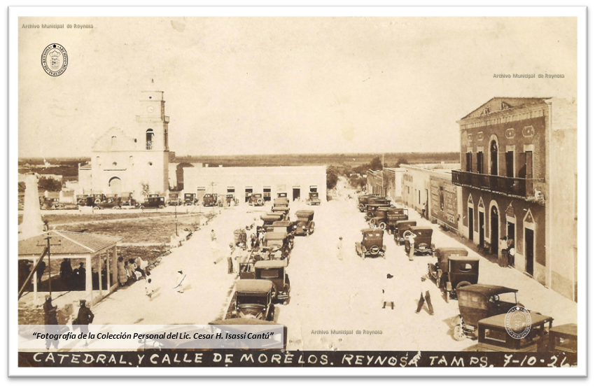
- Casa Consistorial, Iglesia y Plaza durante los festejos del primer puente Internacional, 10 de Julio de 1926, Unknown author Unknown author, CC BY-SA 3.0
- Lerema accius 1, Anne Toal from US, CC BY 2.0
- Tropical Checkered-Skipper (Pyrgus oileus) dorsal, Anne Toal Camera location 26° 05′ 48.3″ N, 98° 15′ 40.6″ W View this and other nearby images on: OpenStreetMap 26.096750; -98.261278, CC BY 2.0
- Texan Crescent (Phyciodes texana) dorsal, Anne Toal Camera location 26° 05′ 48.3″ N, 98° 15′ 40.6″ W View this and other nearby images on: OpenStreetMap 26.096750; -98.261278, CC BY 2.0
- Clouded Skipper (Lerema accius) male dorsal 3, Anne Toal Camera location 26° 05′ 48.5″ N, 98° 15′ 41″ W View this and other nearby images on: OpenStreetMap 26.096806; -98.261389, CC BY 2.0
- Long-tailed skipper (Urbanus proteus), Anne Toal from US, CC BY 2.0
- Great southern white (Ascia monuste) female dorsal, Anne Toal from US, CC BY 2.0
- Malachite (Siproeta stelenes) ventral, Anne Toal from US, CC BY 2.0
- Great southern white (Ascia monuste) female ventral, Anne Toal from US, CC BY 2.0
- Coyote cloudywing (Achalarus toxeus) dorsal, Anne Toal from US, CC BY 2.0
- Malachite (Siproeta stelenes) dorsal (1), Anne Toal from US, CC BY 2.0
- Eufala Skipper (Lerodea eufala), Anne Toal from US, CC BY 2.0
- Lyside sulphur (Kricgonia lyside) with bee, Anne Toal from US, CC BY 2.0
- Long-tailed skipper (Urbanus proteus) (1), Anne Toal from US, CC BY 2.0
- Tulcis Crescent (Anthanassa tulcis) ventral, Anne Toal from US, CC BY 2.0
- Fatal metalmark (Calephelis nemesis) ventral, Anne Toal from US, CC BY 2.0
- Theona checkerspot (Chlosyne theona) dorsal, Anne Toal from US, CC BY 2.0
- CRUZ DEL MIGRANTE, DGAPA, CC BY-SA 3.0
- Tarde de verano después de la lluvia, Pastor lozano higa, CC BY-SA 3.0
- Cielo azul - panoramio (1), 18jcr, CC BY-SA 3.0
- Unidad y Progreso, 88589 Reynosa, Tamps., Mexico - panoramio, 18jcr, CC BY-SA 3.0
- Reynosa, Tamaulipas, Mexico - panoramio, 18jcr, CC BY-SA 3.0
- F1 McDonald's Auto, Cristf2005, CC BY 4.0


Page built October 30, 2026. Spotted a mistake? Tell us or suggest a place.