


Hockessin, Delaware
Hockessin is a community of 13,439 people in New Castle County, Delaware.
Why visit Hockessin
Townapedia lists 73 museums and landmarks, 16 parks and trails, 29 places to eat, 1 place to stay and 2 attractions in and around town.
Highlights include S. P. Dixon Farm, J. Mason Farm, Auburn Valley State Park and Fieldstone Golf Club.
July is the warmest month, with average highs of 84°F; January lows average 24°F.
Weather in Hockessin
Forecast from the National Weather Service. Full forecast
About Hockessin
Hockessin () is a census-designated place (CDP) in New Castle County, Delaware, United States. The population was 13,478 at the 2020 Census.
From the Wikipedia article Hockessin, Delaware (this version), under CC BY-SA 4.0.
Things to do2

Museums and landmarks73

S. P. Dixon Farm
Monument and historic site · National Register of Historic Places · 1.4 mi
Barn in Delaware, United States of America

J. Mason Farm
Monument and historic site · National Register of Historic Places · 1.7 mi
Barn in Delaware, United States of America

J. McIntyre Farm
Monument and historic site · National Register of Historic Places · 2.4 mi
Human settlement in New Castle County, Delaware, United States of America

Auburn Mills Historic District
Monument and historic site · National Register of Historic Places · 1.7 mi
National historic district near Yorklyn, New Castle County, Delaware, United States

Cloud-Reese House
Monument and historic site · National Register of Historic Places · 3.0 mi
Historic house in Delaware, United States
2202 Old Kennett Road, Wilmington
Coffee Run Mission Site
Monument and historic site · National Register of Historic Places · 1.5 mi
Historic district in New Castle County, Delaware, USA
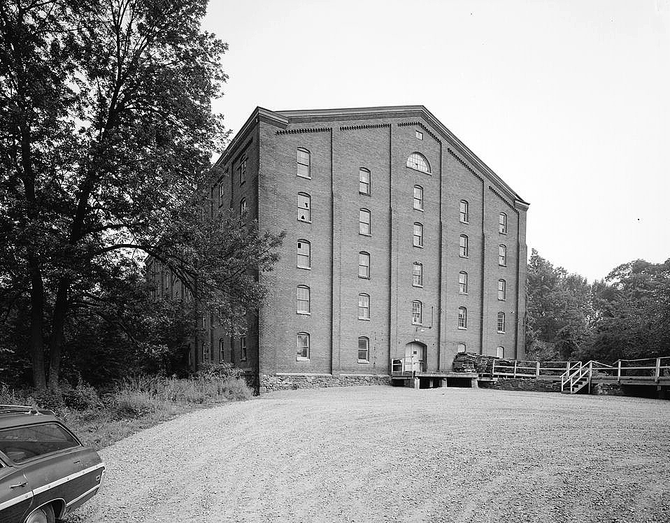
Garrett Snuff Mills Historic District
Monument and historic site · National Register of Historic Places · 1.9 mi
Historic district in Delaware, United States

Graves Mill Historic District
Monument and historic site · National Register of Historic Places · 2.3 mi
Historic district in Delaware, United States

J. Lindsay Barn
Monument and historic site · National Register of Historic Places · 2.3 mi
American historic barn in Delaware

Mt. Cuba Center
Monument and historic site · National Register of Historic Places · 1.6 mi
Historic house in Delaware, United States
We-Su 10:00-18:00
Public School No. 29
Monument and historic site · National Register of Historic Places · 1.3 mi
Library

Stockton-Montmorency
Monument and historic site · National Register of Historic Places · 2.7 mi
Historic house in Delaware, United States
61 more on the map.
Parks, trails and playgrounds16






4 more on the map.
Restaurants and cafes29

El Diablo Burritos, Pike Creek
Restaurant · Tex-Mex · 2.8 mi
5329A Limestone Road, Wilmington
Su-Sa 11:00-21:00

Friendly's
Diner · American · 1.9 mi
80 Lantana Drive, Hockessin
Mo-Th,Su 11:00-22:00; Fr-Sa 11:00-23:00
Harper's Asian Bistro
Restaurant · Asian · 1.8 mi
228 Lantana Drive, Hockessin
Mo-Th 11:00-21:30; Fr-Sa 11:00-22:00; Su 12:00-21:30
La Tonalteca
Restaurant · Mexican · 1.8 mi
700 Lantana Drive, Hockessin
Mo-Th,Su 12:00-21:00; Fr-Sa 12:00-22:00
Redfire Grill Steakhouse
Restaurant · Steak House · 1.8 mi
400 Lantana Drive, Hockessin
Mo-Sa 11:30-22:00; Su 11:00-21:00

Starbucks
Cafe · Coffee Shop · 2.1 mi
6280 Limestone Road, Hockessin
Mo-Fr 05:00-20:00; Sa-Su 06:00-19:30
Stone Mill Pizza
Restaurant · Pizza, Italian, Sandwich, American, Salad, Donut · 0.9 mi
7313 Lancaster Pike, Hockessin
We,Th,Su 12:00-20:00; Fr-Sa 12:00-21:00

Dew Point Brewing Company
Brewery and winery · 1.8 mi
2878 Creek Road, Hockessin
Th 16:00-21:00; Fr 15:00-21:00; Sa 13:00-21:00; Su 13:00-19:00
Mexican Table Restaurant
Restaurant · 0.9 mi
7288 Lancaster Pike, Hockessin
Su,Mo,Tu 11:00-21:00; We-Sa 11:00-22:00
17 more on the map.
History
Hockessin came into existence as a little village in 1688 when several families settled in the area. The village was named after the Lenape word hokes, meaning good bark or good bark hill. There is a second and more likely origin for the name. While the word Hockessin does look like a Native American word, the name Hockessin did not show up on any early maps until many years after the Hockessin Meeting House was built and what is now the Village of Hockessin was never settled by the Native Americans, while they did have a hunting camp nearby. There was no town name Hockessin and the area was referred to as Mill Creek Hundred. The actual name is believed to be derived from one of the first settled properties which was named Occasion and settled by William Cox in 1726 and also the location of the first Quaker meetings in the area before Hockessin Meeting House was built a few years later. The earliest known use of the word Occasion was in 1734 in a property deed for this property. And the road to the Hockessin Meeting House, currently Old Wilmington Road, was written as Ockession Road on a map in 1808. The first Roman Catholic church in Delaware was located in Hockessin. Missionary priests from Maryland established the Coffee Run Mission in 1790.
From the History section of Hockessin, Delaware on Wikipedia, under CC BY-SA 4.0.
Where to stay1
Churches and places of worship13
Red Clay Creek Presbyterian Church
Church · Presbyterian Church Usa · 2.3 mi
500 McKennans Church Road, Wilmington
Hockessin Friends Meetinghouse
Church · Quaker · National Register of Historic Places · 1.0 mi
1501 Old Wilmington Road, Hockessin
Wilmington Community Evangelical Church
Church · Evangelical · 1.8 mi
1512 Brackenville Road, Hockessin
St. Mary of the Assumption
Church · Roman Catholic · 0.4 mi
7200 Lancaster Pike, Hockessin
Shopping5
Gas and EV charging2
Schools, colleges and libraries40
Baltz (Austin D.) Elementary School
School · 5.0 mi
1500 Spruce Avenue, Wilmington
Calloway (Cab) School of The Arts
School · 5.2 mi
100 North Dupont Road, Wilmington
Healthcare5
Map of Hockessin
186 places. The map loads OpenStreetMap tiles when you open it.
Climate by month
Monthly table
| Month | High | Low | Rain | Snow |
|---|---|---|---|---|
| Jan | 38°F | 24°F | 3.7 in | 5.3 in |
| Feb | 41°F | 25°F | 3.0 in | 4.0 in |
| Mar | 49°F | 32°F | 4.7 in | 1.8 in |
| Apr | 61°F | 42°F | 4.1 in | 0.0 in |
| May | 71°F | 52°F | 3.8 in | 0.0 in |
| Jun | 79°F | 62°F | 4.7 in | 0.0 in |
| Jul | 84°F | 67°F | 5.2 in | 0.0 in |
| Aug | 82°F | 66°F | 4.4 in | 0.0 in |
| Sep | 75°F | 59°F | 5.1 in | 0.0 in |
| Oct | 63°F | 47°F | 4.1 in | 0.0 in |
| Nov | 52°F | 37°F | 3.2 in | 0.1 in |
| Dec | 43°F | 29°F | 4.4 in | 0.8 in |
U.S. Climate Normals 1991-2020 for Wilmington Porter Rsch Hcn (7 mi away), NOAA NCEI.
People and cost of living
American Community Survey 5-year estimates, 2020-2024, U.S. Census Bureau. Estimates have margins of error, larger for small towns.
Disaster history
New Castle County has had 13 federal disaster declarations since 2000, most often for hurricanes.
- 2021-10-24: Remnants Of Hurricane Ida (Hurricane)
- 2020-10-02: Tropical Storm Isaias (Hurricane)
- 2020-04-05: Covid-19 Pandemic (Biological)
- 2020-03-13: Covid-19 (Biological)
- 2012-11-16: Hurricane Sandy (Hurricane)
- 2012-10-29: Hurricane Sandy (Hurricane)
OpenFEMA disaster declarations summaries.
Getting there and nearby towns
New Castle County Airport (ILG) is the nearest airport with scheduled flights listed in OpenStreetMap, 8 miles away.
- Pike Creek Valley 4 mi south, about 7 min by car
- Wilmington 8 mi southeast, about 14 min by car
- Newark 8 mi southwest, about 14 min by car
- Brookside 8 mi south, about 13 min by car
- Bear 11 mi south, about 18 min by car
- Glasgow 13 mi south, about 21 min by car
- Middletown 24 mi south, about 38 min by car
- Philadelphia 33 mi northeast, about 53 min by car
- Smyrna 34 mi south, about 55 min by car
- Dover 44 mi south, about 1 h 15 min by car
Drive times are estimates from straight-line distance, not routes.
Local news
Headlines from INDB, the NEMICO news database.
Reviews, tips and questions
Loading what members have shared...
Sources and licences
- NCES EDGE (Public domain): public schools
- NOAA NCEI U.S. Climate Normals 1991-2020 (Public domain): climate by month
- OpenFEMA (Public domain): disaster declarations
- OpenStreetMap contributors (ODbL 1.0): places, airports, map data
- U.S. Census Bureau (Public domain): population, income, housing, education, commute
- Wikidata (CC0 1.0): elevation, founding date, time zone, website, landmarks and historic places
- Wikimedia Commons (see each image): photos
- Wikipedia (CC BY-SA 4.0): overview and history text
Photo credits
- Newly renovated Hockessin Library, Cschroeder999, CC BY-SA 3.0
- AArmstrongFarmHockessinDE, Valerie Cesna, Public domain
- 2022-07-25 17 23 14 View north along Delaware State Route 41 (Lancaster Pike) at School House Road in Hockessin, New Castle County, Delaware, Famartin, CC BY-SA 4.0
- Old Lancaster Pike in Hockessin, Cschroeder999, CC BY-SA 3.0
- Hockessin Police Athletic League, Cschroeder999, CC BY-SA 3.0
- Lancaster Pike in Hockessin, facing north, Cschroeder999, CC BY-SA 3.0
- Hindu Temple Hockessin DE, Smallbones, CC0
- Hockessin Friends 1738 datestone, Smallbones, CC0
- 2022-07-29 11 12 52 View east along Delaware State Route 48 (Lancaster Pike) at Delaware State Route 41 (Newport Gap Pike) in Hockessin, New Castle County, Delaware, Famartin, CC BY-SA 4.0
- Swift Memorial Park in Hockessin, Cschroeder999, CC BY-SA 3.0
- Lamborn Library Hockessin DE, Smallbones, CC0
- 3277 Barley Mill Road, Hockessin, DE, JERRYE AND ROY KLOTZ, M.D., CC BY-SA 4.0
- Lancaster Pike in Hockessin, facing south, Cschroeder, CC BY-SA 3.0
- J. MASON FARM, NEWARK, NORTHERN NEW CASTLE COUNTY DE, JERRYE & ROY KLOTZ, M.D., CC BY-SA 4.0
- J. MCINTYRE FARM, NEWARK, NORTHERN NEW CASTLE COUNTY, DE, JERRYE & ROY KLOTZ, M.D., CC BY-SA 4.0
- Auburn Mill DE, Smallbones, CC0
- Foamflower Tiarella 'Cygnet' Flower Closeup 2000px, Photo by and (c)2007 Derek Ramsey ( Ram-Man ), GFDL 1.2
- GRAVES MILL HISTORIC DISTRICT, NEW CASTLE COUNTY, DE, JERRYE & ROY KLOTZ M.D., CC BY-SA 4.0
- Cloud Reese 1, Smallbones, CC0
- J. Lindsay Barn side and rear, Choess, CC BY-SA 4.0
- Alan Wood House, Choess, CC BY-SA 4.0
- STOCKTON-MONTMORENCY, GREENVILLE, NEW CASTLE COUNTY, DE, JERRYE & ROY KLOTZ, M.D., CC BY-SA 4.0
- Garrett Snuff Mill HAER DE1, George Rineer, HABS photographer, Public domain
- Hockessin Friends from NW, Smallbones, CC0
- Centreville HD Del Odd Fellows, Smallbones, CC0
- Springer Tavern DE, Smallbones, CC0
- Blacks Mill, Jackmacmac, CC BY-SA 3.0
- Mt Airy School Cville DE, Smallbones, CC0
- R. WALKER BARN, NORTHERN NEW CASTLE COUNTY, DE, JERRYE & ROY KLOTZ, M.D., CC BY-SA 4.0
- Chandler Mill Bridge, Smallbones, Public domain
- Holladay-Harrington House, Choess, CC BY-SA 4.0
- J Eastburn barn DE, Smallbones, Public domain
- JMcCormackFarmMillCreekHundredDE, Valerie Cesna, Public domain
- Mt Cuba HD DE, Smallbones, CC0
- Fell Swiss Hist Dist DE, Smallbones, CC0
- Justis Jones house DE, Smallbones, CC0
- Stinson Barn Newark DE, Smallbones, Public domain
- James Armor House DE, Smallbones, CC0
- WOODDALE BRIDGE, ROY KLOTZ MD, CC BY-SA 3.0
- Owls Nest Delaware, Smallbones, CC0


Page built October 30, 2026. Spotted a mistake? Tell us or suggest a place.