
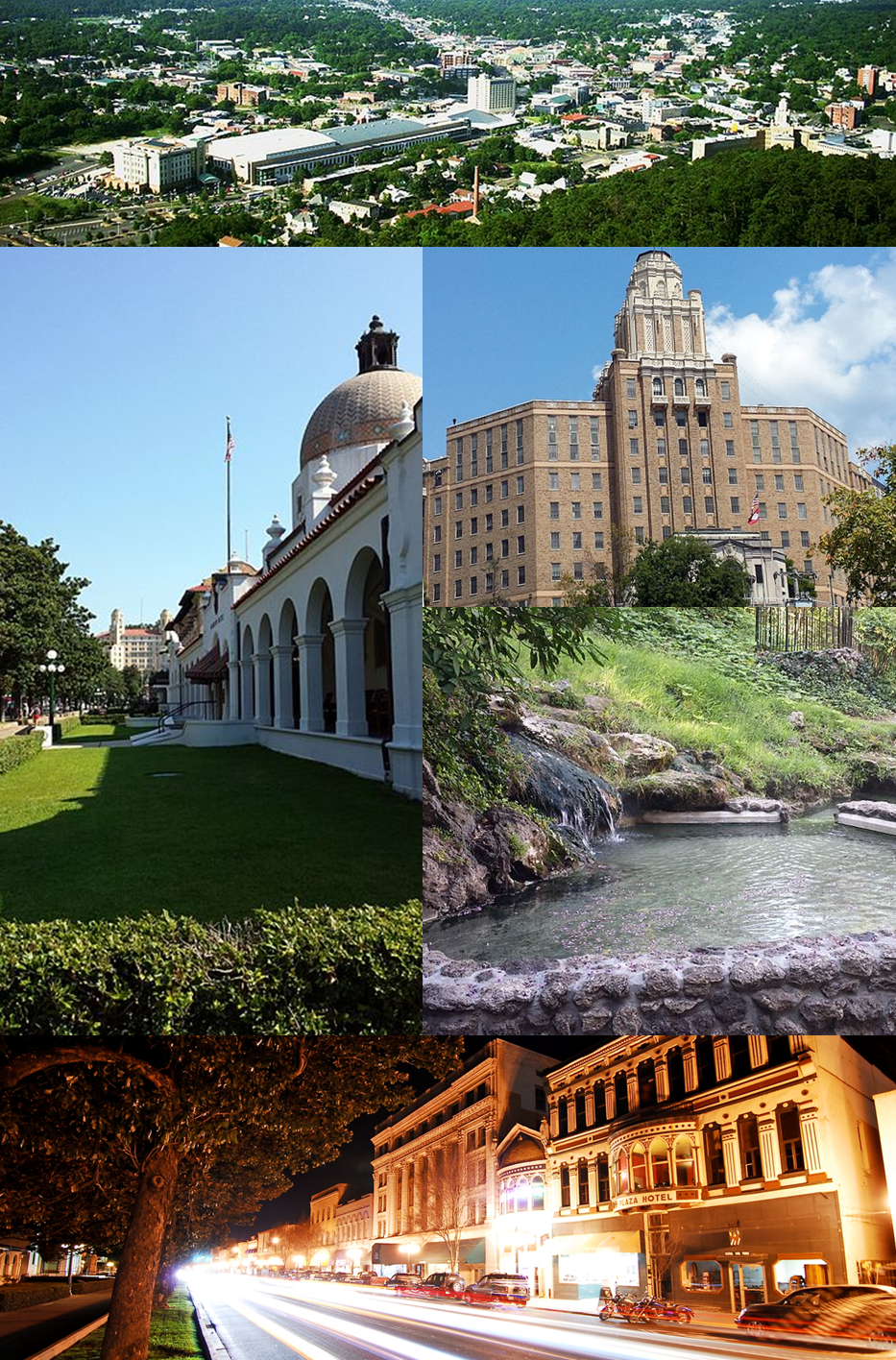


Hot Springs, Arkansas
Hot Springs is a city of 37,920 people in Garland County, Arkansas, founded in 1832.
Why visit Hot Springs
Townapedia lists 82 museums and landmarks, 32 parks and trails, 66 places to eat, 35 places to stay and 12 attractions in and around town.
Highlights include AMC CLASSIC Central City 10, Hot Springs 8 VIP Cinema, Bathhouse Row and Hot Springs Confederate Monument.
July is the warmest month, with average highs of 93°F; January lows average 32°F.
Weather in Hot Springs
Forecast from the National Weather Service. Full forecast
About Hot Springs
Hot Springs is a resort city in the state of Arkansas, United States, and the county seat of Garland County. The city is located in the Ouachita Mountains among the U.S. Interior Highlands, and is set among several natural hot springs for which the city is named. As of the 2020 United States census, the city had a population of 37,930, making it the eleventh-most populous city in Arkansas.
From the Wikipedia article Hot Springs, Arkansas (this version), under CC BY-SA 4.0.
Things to do12


Hot Springs Mountain Tower
Monument and historic site · 1.9 mi
Observation tower
Magic Springs and Crystal Falls
Monument and historic site · 2.8 mi
Amusement park

Goat Rock Viewpoint
Scenic view · 2.7 mi
Off Goat Rock Trail, Hot Springs National Park
Timberwood Ampitheater
Cinema and theater · 3.0 mi
1701 East Grand Avenue, Hot Springs

Museums and landmarks82

Bathhouse Row
Monument and historic site · National Register of Historic Places · 1.7 mi
Park in Hot Springs, Garland County, United States of America

Hot Springs Confederate Monument
Monument and historic site · National Register of Historic Places · 1.3 mi
Monument in Arkansas, United States of America

Aristocrat Manor Apartments
Monument and historic site · National Register of Historic Places · 1.9 mi
United States historic place
Belding-Gaines Cemetery
Monument and historic site · National Register of Historic Places · 4.3 mi
Historic cemetery in Arkansas, United States
Bellaire Court Historic District
Monument and historic site · National Register of Historic Places · 2.4 mi
Historic district in Hot Springs, Arkansas

Bill Clinton Boyhood Home
Monument and historic site · National Register of Historic Places · 2.9 mi
Hot Springs, Arkansas, listed on the NRHP in Arkansas
Central Avenue Historic District
Monument and historic site · National Register of Historic Places · 1.8 mi
Historic district in Hot Springs, Arkansas, USA
Charles N. Rix House
Monument and historic site · National Register of Historic Places · 1.3 mi
Historic house in Arkansas, United States

Citizens Building
Monument and historic site · National Register of Historic Places · 1.7 mi
Bank building in Arkansas, United States of America
Cleveland Arms Apartment Building
Monument and historic site · National Register of Historic Places · 0.6 mi
Historic building in Arkansas, US

Cottage Courts Historic District
Monument and historic site · National Register of Historic Places · 2.4 mi
Historic district in Arkansas, United States


Cove Tourist Court
Monument and historic site · National Register of Historic Places · 2.6 mi
Hotel in Arkansas, United States of America
70 more on the map.
Parks, trails and playgrounds32


Magic Springs Theme & Water Park
Sports field and stadium · 2.8 mi
1701 East Grand Avenue, Hot Springs
Arkansas Alligator Farm and Petting Zoo
Park · 2.2 mi
The Arkansas Alligator Farm and Petting Zoo is a zoological park in Arkansas, United States of America, primarily involved in the...
Hot Springs National Park
Park · 1.7 mi
United States National Park in central Arkansas


Hill Wheatley Park
Park · 4.8 mi
Boat Launch, Courtesy Dock, Fishing, Grill, Natural Surface Walking Trail, Parking, Picnic Tables, Restrooms, Sand Beach, Swimming,...
688 Majestic Lodge Road, Hot Springs
20 more on the map.
Restaurants and cafes66

Chili's
Restaurant · Tex-Mex · 1.9 mi
3815 Central Avenue, Hot Springs
Mo-Th,Su 10:45-22:00; Fr,Sa 10:45-23:00
La Hacienda
Restaurant · Mexican · 2.1 mi
3836 Central Avenue, Hot Springs
Mo-Th,Su 11:00-20:00; Fr,Sa 11:00-20:30
LongHorn Steakhouse
Restaurant · Steak House · 1.9 mi
1470 Higdon Ferry Road, Hot Springs
Mo-Th,Su 11:00-22:00; Fr-Sa 11:00-23:00
Olive Garden
Restaurant · Italian · 2.6 mi
4108 Central Avenue, Hot Springs
Mo-Th,Su 11:00-22:00; Fr,Sa 11:00-23:00
Rocky's Corner
Restaurant · Italian · 0.6 mi
2600 Central Avenue, Hot Springs
Mo-Th,Su 11:00-22:00; Fr,Sa 11:00-23:00
Colonial Pancake & Waffle House
Restaurant · 2.0 mi
111 Central Avenue, Hot Springs National Park
Fr-Tu 07:00-14:30

Maxine's Live
Bar and pub · 1.5 mi
700 Central Avenue, Hot Springs
Mo-Fr 17:00-02:00, Sa 14:00-02:00, Su 12:00-24:00


Winery of Hot Springs
Brewery and winery · 0.7 mi
1503 Central Avenue, Hot Springs
Mo-Th,Su 10:00-18:00; Fr,Sa 10:00-20:00
54 more on the map.
Where to stay35
Churches and places of worship57
Central Methodist Episcopal Church South
Church · National Register of Historic Places · 1.1 mi
First Lutheran Church
Church · National Register of Historic Places · 0.6 mi
Sharon Seventh-day Adventist Church
Church · Seventh Day Adventist · 1.1 mi
223 Silver Street, Hot Springs
Shopping14
Gas and EV charging17
Schools, colleges and libraries39
Arkansas School for Mathematics, Sciences, and the Arts
School · 2.1 mi
200 Whittington Avenue, Hot Springs
Healthcare3
CHI St. Vincent Hot Springs Rehabilitation Hospital
Hospital · 2.2 mi
1636 Higdon Ferry Road, Hot Springs
Map of Hot Springs
250 places. The map loads OpenStreetMap tiles when you open it.
Climate by month
Monthly table
| Month | High | Low | Rain | Snow |
|---|---|---|---|---|
| Jan | 52°F | 32°F | 3.8 in | 0.6 in |
| Feb | 56°F | 35°F | 4.6 in | 0.4 in |
| Mar | 65°F | 42°F | 5.5 in | 0.1 in |
| Apr | 74°F | 51°F | 5.9 in | 0.0 in |
| May | 80°F | 60°F | 6.5 in | 0.0 in |
| Jun | 88°F | 68°F | 4.3 in | 0.0 in |
| Jul | 93°F | 72°F | 4.5 in | 0.0 in |
| Aug | 93°F | 71°F | 3.6 in | 0.0 in |
| Sep | 86°F | 64°F | 4.2 in | 0.0 in |
| Oct | 75°F | 52°F | 5.1 in | 0.0 in |
| Nov | 62°F | 42°F | 4.9 in | 0.0 in |
| Dec | 53°F | 35°F | 5.0 in | 0.0 in |
U.S. Climate Normals 1991-2020 for Hot Springs 1 Nne (2 mi away), NOAA NCEI.
People and cost of living
American Community Survey 5-year estimates, 2020-2024, U.S. Census Bureau. Estimates have margins of error, larger for small towns.
Disaster history
Garland County has had 15 federal disaster declarations since 2000, most often for severe storms.
- 2026-01-24: Severe Winter Storm (Winter Storm)
- 2025-05-21: Severe Storms, Tornadoes, And Flooding (Flood)
- 2025-04-05: Severe Storms, Tornadoes, And Flooding (Severe Storm)
- 2020-08-27: Hurricane Laura (Hurricane)
- 2020-04-03: Covid-19 Pandemic (Biological)
- 2020-03-13: Covid-19 (Biological)
OpenFEMA disaster declarations summaries.
Getting there and nearby towns
Memorial Field (HOT) is the nearest airport with scheduled flights listed in OpenStreetMap, 2 miles away.
- Hot Springs Village 13 mi north, about 20 min by car
- Malvern 15 mi southeast, about 25 min by car
- Arkadelphia 25 mi south, about 40 min by car
- Benton 28 mi east, about 45 min by car
- Bryant 33 mi east, about 53 min by car
- Little Rock 43 mi east, about 1 h 15 min by car
- Maumelle 45 mi northeast, about 1 h 15 min by car
- North Little Rock 51 mi northeast, about 1 h 15 min by car
- Conway 52 mi northeast, about 1 h 30 min by car
- Sherwood 54 mi northeast, about 1 h 30 min by car
Drive times are estimates from straight-line distance, not routes.
Local news
Headlines from INDB, the NEMICO news database.
Reviews, tips and questions
Loading what members have shared...
Sources and licences
- NCES EDGE (Public domain): public schools
- NOAA NCEI U.S. Climate Normals 1991-2020 (Public domain): climate by month
- OpenFEMA (Public domain): disaster declarations
- OpenStreetMap contributors (ODbL 1.0): places, airports, map data
- U.S. Census Bureau (Public domain): population, income, housing, education, commute
- Wikidata (CC0 1.0): elevation, founding date, time zone, website, landmarks and historic places
- Wikimedia Commons (see each image): photos
- Wikipedia (CC BY-SA 4.0): overview and history text
Photo credits
- Hot Springs collage, Brandonrush, CC BY-SA 3.0
- Hot Springs, Arkansas - 1915, Ice Wagon (5523904376), duggar11, CC BY 2.0
- Forest Service Headquarters Historic District, Hot Springs, AR, Valis55, CC BY-SA 3.0
- Cleveland Arms Apartment Building, Hot Springs, Arkansas, Eric Friedebach, CC BY 2.0
- Cleveland Arms Apartment Building, Hot Springs, Arkansas - 51133026622, Eric Friedebach, CC BY 2.0
- First Lutheran Church, Hot Springs, AR, Valis55, CC BY-SA 3.0
- Jones School in Hot Springs, AR 003, Brandonrush, CC BY-SA 3.0
- Jones School in Hot Springs, AR 002, Brandonrush, CC BY-SA 3.0
- Jones School in Hot Springs, AR 001, Brandonrush, CC BY-SA 3.0
- Hot Springs, Arkansas (4705724626), Kurt Bauschardt from Edmonton, Canada, CC BY-SA 2.0
- Grand Avenue and Malvern Avenue intersect in Hot Springs, AR, Brandonrush, CC BY-SA 3.0
- Superiour Bathhouse, Hot Springs, Arkansas (7662301714), Rennett Stowe from USA, CC BY 2.0
- HABS ARK,26-HOSP,2- (sheet 2 of 5) - Pythian Bathhouse and Hotel, 415 Malvern Avenue, Hot Springs, Garland County, AR, Related names: Knights of Pythian; Bailey, W T; McDaniel, D; Kliwinski, Leonard, field team; McCall, Gregory, field team; Peters, Michael, project manager; Arkansas Historic Preservation Program..., Public domain
- Buckstaff Bathhouse, daveynin from United States, CC BY 2.0
- Hot Springs Confederate Monument 002, Brandonrush, CC BY-SA 3.0
- Ouachita Avenue Historic District 001, Brandonrush, CC BY-SA 3.0
- Visitors Chapel AME, Valis55, CC BY-SA 3.0
- First Presbyterian Church, Hot Springs, AR, Valis55, CC BY-SA 3.0
- Lynwood Tourist Court Historic District 001, Brandonrush, CC BY-SA 3.0
- Woodmen of Union Building 001, Brandonrush, CC BY-SA 3.0
- Hot Springs Train Station 001, Brandonrush, CC BY-SA 3.0
- Cove Tourist Court, 1 of 3, Valis55, CC BY-SA 3.0
- Jack Tar Hotel and Bathhouse, Valis55, CC BY-SA 3.0
- OldHotSpringsHighSchool, Wasted Time R ( talk ), CC BY-SA 3.0
- Fordyce House, Valis55, CC BY-SA 3.0
- Bill Clinton Boyhood Home (Birnbaum-Shubetz House) 002, Brandonrush, CC BY-SA 3.0
- Malco Theater, Hot Springs, AR 001, Brandonrush, CC BY-SA 3.0
- Mountainaire Hotel Historic District 001, Brandonrush, CC BY-SA 3.0
- Medical Arts Building 001, Brandonrush, CC BY-SA 3.0
- Plaza Apartments, Valis55, CC BY-SA 3.0
- Citizens Building 001, Brandonrush, CC BY-SA 3.0
- Aristocrat Manor Apartments, Marcrez, CC BY-SA 4.0
- Pleasant Street Historic District, 2 of 3, Valis55, CC BY-SA 3.0
- Perry Plaza Court Historic District, Brandonrush, CC BY-SA 3.0
- Cottage Courts Historic District, 1 of 2, Valis55, CC BY-SA 3.0
- 1891 house at 316 Park Ave, Futuronyc, CC BY-SA 3.0
- St. Luke's Episcopal Church, Hot Springs, AR, Valis55, CC BY-SA 3.0
- Federal Building-U.S. Post Office and Court House, Hot Springs, AR, Valis55, CC BY-SA 3.0
- Hill Wheatley Downtowner Motor Inn, Valis55, CC BY-SA 4.0
- Short-Dodson House, Valis55, CC BY-SA 4.0


Page built October 30, 2026. Spotted a mistake? Tell us or suggest a place.