
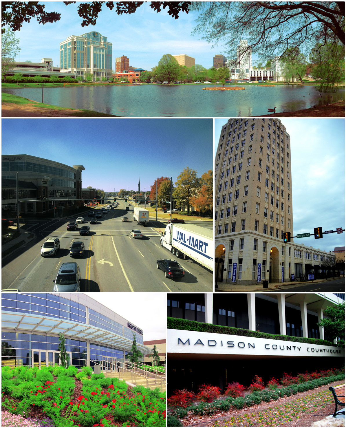


Huntsville, Alabama
Huntsville is a city of 222,791 people in Limestone County, Alabama, founded in 1805.
Why visit Huntsville
Townapedia lists 114 museums and landmarks, 21 parks and trails, 235 places to eat, 2 places to stay and 32 attractions in and around town.
Highlights include Alabama A & M University, Oakwood University, 104–128 South Side Square and 105 South Washington Street.
July is the warmest month, with average highs of 92°F; January lows average 33°F.
Weather in Huntsville
Forecast from the National Weather Service. Full forecast
About Huntsville
Huntsville is the most populous city in the U.S. state of Alabama. The population was 215,006 at the 2020 census, making it the 100th-most populous city in the U.S., while the Huntsville metropolitan area has an estimated 542,000 residents and is the second-most populous metropolitan area in the state. As of July 1, 2025, the city's population was estimated to be 233,627 – a 8.7% increase since the 2020 Census. This makes it among the top 20 fastest growing cities in the US.
From the Wikipedia article Huntsville, Alabama (this version), under CC BY-SA 4.0.
Things to do32

Alabama A & M University
School · 8.9 mi
Historically black land grant university
Oakwood University
School · 4.8 mi
American private Seventh-day Adventist university in Alabama

Southern Adventures
Monument and historic site · 4.6 mi
Amusement park in Alabama
University of Alabama in Huntsville
School · 3.2 mi
Public research university in Huntsville, Alabama

20 more on the map.
Museums and landmarks114

104–128 South Side Square
Monument and historic site · National Register of Historic Places · 5.9 mi
United States historic place

105 South Washington Street
Monument and historic site · National Register of Historic Places · 5.9 mi
United States historic place

305 Jefferson Street
Monument and historic site · National Register of Historic Places · 5.8 mi
United States historic place

Belk Hudson Lofts
Monument and historic site · National Register of Historic Places · 5.9 mi
Department store in Huntsville, United States of America

Big Spring Park
Monument and historic site · National Register of Historic Places · 5.6 mi
Park in Huntsville, Alabama

Clemens House
Monument and historic site · National Register of Historic Places · 6.2 mi
Historic house in Huntsville, Alabama
Edmonton Heights Historic District
Monument and historic site · National Register of Historic Places · 8.6 mi
Historic district in Huntsville, Alabama, United States

Elbert H. Parsons Law Library
Monument and historic site · National Register of Historic Places · 5.9 mi
Law library in a historic building
Episcopal Church of the Nativity
Monument and historic site · National Register of Historic Places · 5.9 mi
Church building in Alabama, United States of America
First National Bank
Monument and historic site · National Register of Historic Places · 5.8 mi
Historic bank building in Huntsville, Alabama, United States

Five Points Historic District
Monument and historic site · National Register of Historic Places · 6.5 mi
Historic district in Alabama, United States


Henderson National Bank
Monument and historic site · National Register of Historic Places · 5.8 mi
Building in Huntsville, Alabama, United States
102 more on the map.
Parks, trails and playgrounds21

Land Trust of North Alabama: Blevins Gap Trailhead North
Hiking and trails · 8.3 mi
2275 Cecil Ashburn Drive Southeast, Huntsville

9 more on the map.
Restaurants and cafes235

The Bottle
Diner · American · 5.9 mi
Reservations: https://www.opentable.com/the-bottle?ref=1068
101 Washington Street Northeast, Huntsville
Mo-Th 16:00-21:00; Fr-Sa 16:00-22:00; Su off

Big Bowl
Restaurant · Thai · 3.7 mi
6125 University Drive Northwest, Huntsville
Mo-Th 11:00-15:00,16:00-20:30; Fr 11:00-15:00,16:00-21:00; Sa...
Carrabba's Italian Grill
Restaurant · Italian · 5.1 mi
2801 Memorial Parkway Southwest, Huntsville
Mo-Th 11:00-22:00; Fr-Sa 11:00-23:00; Su 11:00-21:00
Casa Blanca
Restaurant · Mexican · 7.9 mi
7900 Bailey Cove Road Southeast, Huntsville
Su-Th 11:00-21:00, Fr-Sa 11:00-22:00
Dashu Japanese Cuisine and Bar
Restaurant · Japanese · 5.6 mi
964 Airport Rd SW, Huntsville
Mo-Th 11:00-21:00; Fr, Sa 11:00-22:00; Su 12:00-21:00
Dragon Alley
Restaurant · Chinese · 3.5 mi
1030 Mid City Drive Northwest, Huntsville
Mo-Th 11:00-14:30,16:00-22:00; Fr 11:00-14:30,16:00-24:00; Sa...
Dreamland BBQ
Restaurant · Barbecue · 4.3 mi
3855 University Drive Northwest
Su-Th 10:00-21:00; Fr-Sa 10:00-22:00
Farm Burger
Restaurant · Burger · 5.2 mi
930 Bob Wallace Avenue Southwest, Huntsville
Mo-Su 11:00-21:00
Great Panda Restaurant
Restaurant · Chinese, Fast Food · 5.9 mi
2121 Whitesburg Drive, Huntsville
Mo-Sa 10:30-20:30
Indian Kitchen
Restaurant · Indian · 6.0 mi
4800 Whitesburg Drive South, Huntsville
Tu-Su 11:00-14:00, 16:00-21:00
Jason's Deli
Restaurant · Sandwich · 3.8 mi
1395 Enterprise Way Northwest, Huntsville
Mo-Su 10:00-21:00
223 more on the map.
Where to stay2
Churches and places of worship134
Aldersgate United Methodist Church
Church · United Methodist · 9.1 mi
12901 Bailey Cove Road Southeast, Huntsville
First Seventh-day Adventist Church
Church · Seventh Day Adventist · 3.8 mi
1303 Evangel Drive Northwest, Huntsville
Northwest Church of Christ
Church · Church Of Christ · 7.7 mi
5008 Pulaski Pike Northwest, Huntsville
Shopping48
Gas and EV charging41
Schools, colleges and libraries46
Alabama School of Cybertechnology and Engineering
School · 2.8 mi
229 Wynn Drive Northwest, Huntsville
Academy For Academics Arts Elementary School
School · 5.4 mi
4800 Sparkman Drive Ne, Huntsville
Academy For Academics And Arts Middle School
School · 5.4 mi
4800 Sparkman Drive Ne, Huntsville
Healthcare19
Huntsville Hospital for Women And Children
Hospital · 6.1 mi
245 Governors Drive Southeast, Huntsville
Ross Medical
Clinic and pharmacy · 3.4 mi
930 Old Monrovia Road Northwest, Huntsville
Walgreens
Clinic and pharmacy · 7.4 mi
11399 Memorial Parkway Southwest, Huntsville
Map of Huntsville
250 places. The map loads OpenStreetMap tiles when you open it.
Climate by month
Monthly table
| Month | High | Low | Rain | Snow |
|---|---|---|---|---|
| Jan | 52°F | 33°F | 5.0 in | 0.7 in |
| Feb | 57°F | 36°F | 5.1 in | 1.0 in |
| Mar | 66°F | 43°F | 5.4 in | 0.5 in |
| Apr | 75°F | 51°F | 4.9 in | 0.0 in |
| May | 82°F | 60°F | 4.7 in | 0.0 in |
| Jun | 89°F | 68°F | 4.1 in | 0.0 in |
| Jul | 92°F | 71°F | 4.5 in | 0.0 in |
| Aug | 91°F | 70°F | 3.5 in | 0.0 in |
| Sep | 86°F | 63°F | 3.5 in | 0.0 in |
| Oct | 76°F | 52°F | 3.6 in | 0.0 in |
| Nov | 64°F | 41°F | 4.2 in | 0.0 in |
| Dec | 55°F | 36°F | 5.9 in | 0.2 in |
U.S. Climate Normals 1991-2020 for Huntsville Intl Ap 72323 (7 mi away), NOAA NCEI.
People and cost of living
American Community Survey 5-year estimates, 2020-2024, U.S. Census Bureau. Estimates have margins of error, larger for small towns.
Disaster history
Limestone County has had 14 federal disaster declarations since 2000, most often for hurricanes.
- 2024-09-26: Hurricane Helene (Hurricane)
- 2020-09-14: Hurricane Sally (Hurricane)
- 2020-05-21: Severe Storms And Flooding (Severe Storm)
- 2020-03-29: Covid-19 Pandemic (Biological)
- 2020-03-13: Covid-19 (Biological)
- 2017-09-11: Hurricane Irma (Hurricane)
OpenFEMA disaster declarations summaries.
Getting there and nearby towns
Franklin County Airport (UOS) is the nearest airport with scheduled flights listed in OpenStreetMap, 57 miles away.
- Madison 5 mi west, about 8 min by car
- Meridianville 14 mi north, about 23 min by car
- Athens 17 mi northwest, about 27 min by car
- Decatur 20 mi southwest, about 32 min by car
- Hartselle 23 mi southwest, about 37 min by car
- Scottsboro 36 mi east, about 58 min by car
- Cullman 37 mi south, about 59 min by car
- Albertville 40 mi southeast, about 1 h by car
- Boaz 45 mi southeast, about 1 h 15 min by car
- Muscle Shoals 55 mi west, about 1 h 30 min by car
Drive times are estimates from straight-line distance, not routes.
Local news
Headlines from INDB, the NEMICO news database.
Reviews, tips and questions
Loading what members have shared...
Sources and licences
- NCES EDGE (Public domain): public schools
- NOAA NCEI U.S. Climate Normals 1991-2020 (Public domain): climate by month
- OpenFEMA (Public domain): disaster declarations
- OpenStreetMap contributors (ODbL 1.0): places, airports, map data
- U.S. Census Bureau (Public domain): population, income, housing, education, commute
- Wikidata (CC0 1.0): elevation, founding date, time zone, website, landmarks and historic places
- Wikimedia Commons (see each image): photos
- Wikipedia (CC BY-SA 4.0): overview and history text
Photo credits
- HsvMontage, Larry Wilbourn, CC BY-SA 3.0
- Hotel Russell Erskine Dec2009 02, Chris Pruitt, CC BY-SA 3.0
- 700s Holmes Ave Huntsville Oct 2011 01, Chris Pruitt, CC BY-SA 3.0
- Episcopal Church of the Nativity Huntsville March 2013 1, Chris Pruitt, CC BY-SA 3.0
- Henderson National Bank July 2010 02, Chris Pruitt, CC BY-SA 3.0
- Yarbrough Hotel Dec2009 01, Chris Pruitt, CC BY-SA 3.0
- Joel Eddins House, Morningmurk, CC BY-SA 4.0
- Phelps-Jones House Oct 2011 02, Chris Pruitt, CC BY-SA 3.0
- 105 South Washington Street Huntsville May 2011, Chris Pruitt, CC BY-SA 3.0
- BSP Bridge, No machine-readable author provided. Anivron assumed (based on copyright claims)., CC BY-SA 3.0
- 305 Jefferson St Huntsville Dec2009 01, Chris Pruitt, CC BY-SA 3.0
- Neutral Buoyancy Simulator tank from outside, NASA MSFC Facilities, Public domain
- US Courthouse and Post Office Huntsville Dec2009 01, Chris Pruitt, CC BY-SA 3.0
- Hundley Rental Houses July 2010, Spyder_Monkey, CC BY-SA 3.0
- Kildare-McCormick House Dec10 01, Chris Pruitt, CC BY-SA 3.0
- 16 Main Street Madison Alabama May 2011, Chris Pruitt, CC BY-SA 3.0
- Vaught House Oct 2011, Chris Pruitt, CC BY-SA 3.0
- May & Cooney Dry Goods Dec2009 01, Chris Pruitt, CC BY-SA 3.0
- Randolph St CoC Dec2009 02, Chris Pruitt, CC BY-SA 3.0
- AAMU James H. Wilson Hall Dec10 01, Chris Pruitt, CC BY-SA 2.0
- WILLIAM LANFORD HOUSE, HUNTSVILLE, Jerrye & Roy Klotz, MD, CC BY-SA 4.0
- Jude-Crutcher House Oct 2011 01, Chris Pruitt, CC BY-SA 3.0
- Clemens House Huntsville Dec10 02, Chris Pruitt, CC BY-SA 2.0
- Maple Hill Cemetery Huntsville Alabama Front1, LonelyPilgrim, CC BY 2.5
- S-IC-D positioning for shake test, NASA, Public domain
- Oak Place Feb 2012 03, Chris Pruitt, CC BY-SA 3.0
- Church of the Visitation Huntsville Dec2009 01, Chris Pruitt, CC BY-SA 3.0
- 703 & 705 Ward Ave Huntsville Oct 2011, Chris Pruitt, CC BY-SA 3.0
- Lincoln School Huntsville Dec10 02, Chris Pruitt, CC BY-SA 3.0
- MONTE SANO RAILROAD WORKERS’ HOUSE, HUNTSVILLE, MADISON COUNTY, AL, Jerrye & Roy Klotz, MD, CC BY-SA 4.0
- Hundley House July 2010 02, Chris Pruitt, CC BY-SA 3.0
- Huntsville Depot July 2010 03, Chris Pruitt, CC BY-SA 3.0
- Belk-Hudson Lofts March 2013 2, Chris Pruitt, CC BY-SA 3.0
- Kelly Bros & Rowe Building Dec2009 01, Chris Pruitt, CC BY-SA 3.0
- Kress Building Huntsville May 2011, Chris Pruitt, CC BY-SA 3.0
- White-Turner-Sanford House July 2010 01, Chris Pruitt, CC BY-SA 3.0
- Withers-Chapman House Feb 2012 02, Chris Pruitt, CC BY-SA 3.0
- Mrs. William Robinson House Dec10 02, Chris Pruitt, CC BY-SA 3.0
- Rand Building Huntsville July 2010 01, Chris Pruitt, CC BY-SA 3.0
- 112-116 South Side Square, Chris Pruitt, CC BY-SA 3.0


Page built October 30, 2026. Spotted a mistake? Tell us or suggest a place.