


Kediri, Indonesia
Kediri is a town of 301,424 people in East Java, Indonesia, founded in July 31, 879.
Why visit Kediri
Townapedia lists 13 museums and landmarks, 19 parks and trails, 31 places to eat, 11 places to stay and 8 attractions in and around town.
Highlights include Simpang Lima Gumul Monument, Museum Fotografi Kediri and Brawijaya Stadium.
Weather in Kediri
Forecast from MET Norway (CC BY 4.0). Full forecast
About Kediri
Kediri (Javanese: ꦏꦸꦛꦏꦝꦶꦫꦶ, Kutha Kadhiri, Javanese pronunciation: [ku.ʈa kə.d̪i.ri]) is a city, located near the Brantas River in the province of East Java on the island of Java in Indonesia. It covers an area of 67.23 km2 and had a population of 268,950 at the 2010 Census and 286,796 at the 2020 Census; the official estimate as of mid 2025 was 301,815 (comprising 149,851 males and 151,964 females).
From the Wikipedia article Kediri (city) (this version), under CC BY-SA 4.0.
Things to do8


Museums and landmarks13
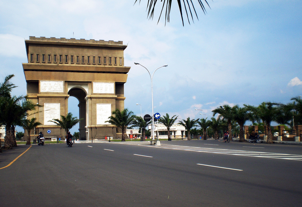


Simpang Lima Gumul Monument
Monument and historic site · 5.0 km
Monument in Kediri Regency, East Java, Indonesia


Kampung Tahu Tinalan
Monument and historic site · 1.9 km
Perkumpulan produsen tahu yang digagas untuk menjadi Kampung Keren oleh Pemkot Kediri
Jalan Tinalan Gang 4, Kediri
1 more on the map.
Parks, trails and playgrounds19


7 more on the map.
Restaurants and cafes31


Mie Djoetek Ngronggo
Restaurant · Indonesian · 3.5 km
Jalan Kapten Pierre Tendean, kediri
Mo-Su 10:00-21:00
Soto Ayam Lamongan "Pak Suin" Kediri
Restaurant · 3.2 km
Jalan Gg. Pemenang 3, Katang, Sukorejo, Kec. Ngasem, Kabupaten Kediri, Jawa Timur 64182
Mo-Su 08:00-17:00
TAUTAN COFFEE
Cafe · 2.2 km
19 Mauni
Mo-Fr,Su 08:00-22:00; Sa 08:00-23:00
Kedai Kopi Moe Kediri
Cafe · 2.7 km
Jl. Soekarno Hatta No.22, Katang, Sukorejo, Kec. Ngasem, Kabupaten Kediri, Jawa Timur 64182
Mo-Su 09:00-23:00

19 more on the map.
History
Traditionally, the city of Kediri is said to have been founded on 27 July 879, and today the city's anniversary is celebrated on that date. The Brantas River valley was known as the site of classical Javanese culture, particularly between the 10th and 15th centuries. The town of Kediri was established by King Airlangga on the banks of the upper Brantas River in 1042. It was originally called Dahanapura or Daha. After the death of Airlangga his kingdom was divided into two parts: the kingdom of Panjalu in the west, and the kingdom of Janggala in the east. Daha became the capital of Panjalu, and later the capital of the Kediri kingdom. Over the centuries, control of the city passed to the Singhasari, Majapahit, Demak and Mataram kingdoms.
The name "Kediri", or "Kadiri", is derived from the Sanskrit word Khadri, meaning Indian Mulberry, indicative of the mulberry trees (locally known as pacé or mengkudu) which grew in the area.
From the History section of Kediri (city) on Wikipedia, under CC BY-SA 4.0.
Where to stay11
Churches and places of worship39
Gereja Isa Almasih Kediri
Place of worship · 1.4 km
Jalan Inspeksi Brantas No 20, Mojoroto, Kecamatan Mojoroto , Kota Kediri
Gereja Bethel Tabernakel "Kristus Pengasih"
Church · 1.0 km
Jalan Sam Ratulangi, Kediri
Masjid Al-Ma'ruf Badal Pandean
Place of worship · 5.5 km
Badal Pandean, Ngadiluwih, Kediri
Shopping18
Gas and EV charging17
SPBU Pertamina 54.641.36
Gas station · 6.3 km
Jl. Kertosono - Tulungagung No.39, Tegalrejo, Banjarejo, Kec. Ngadiluwih, Kabupaten Kediri, Jawa Timur 64171, Kabupaten Kediri
SPBU Pertamina 54.641.11
Gas station · 2.8 km
Jl. Urip Sumoharjo No.417, Ngronggo, Kec. Kota, Kabupaten Kediri, Jawa Timur 64127, Kabupaten Kediri
Pertamina
Gas station · 1.5 km
52C6+C4F, Kaliombo, Kota, Kota Kediri, East Java 64129, Kota Kediri
Pertamina
Gas station · 1.7 km
Jl. Mayor Bismo No.28, Semampir, Kec. Kota, Kodya Kediri, Jawa Timur 64112, Kota Kediri
Pertamina
Gas station · 3.5 km
Jl. Semeru No.261, Campurejo, Kec. Mojoroto, Kota Kediri, Jawa Timur 64116, Kota Kediri
Pertamina
Gas station · 3.6 km
Jl. Gatot Subroto, Ngampel, Kec. Mojoroto, Kabupaten Kediri, Jawa Timur 64111, Kabupaten Kediri
Pertamina
Gas station · 4.3 km
Jl. Kertosono-Kediri, Putih, Kec. Gampengrejo, Kabupaten Kediri, Jawa Timur 64182, Kabupaten Kediri
SPBU Pertamina 54.641.40
Gas station · 3.0 km
Jl. Raung No.8, Bandar Kidul, Kec. Mojoroto, Kabupaten Kediri, Jawa Timur 64117, Kabupaten Kediri
SPBU Pertamina 54.641.42
Gas station · 5.6 km
Jl. Kapten Tendean No.337, Blabak, Kec. Pesantren, Kota Kediri, Jawa Timur 64135, Kota Kediri
Schools, colleges and libraries61
SMA Katolik Santo Augustinus (SMAK Augustinus Kediri)
School · 1.7 km
3 Jl. Veteran No.3, Mojoroto, Kec. Mojoroto, Kota Kediri, Jawa Timur 64112
Universitas Dian Nuswantoro Kediri (Udinus Kediri)
School · 1.9 km
Jl. Penanggungan No.41a, Bandar Lor, Kec. Kota, Kota Kediri, Jawa Timur 64129
Institut Ilmu Kesehatan Bhakti Wiyata
School · 1.1 km
Jalan K.H. Wahid Hasyim, Kediri
Healthcare35
Map of Kediri
250 places. The map loads OpenStreetMap tiles when you open it.
Getting there and nearby towns
Dhoho Airport (DHX) is the nearest airport with scheduled flights listed in OpenStreetMap, 11 km away.
- Gampengrejo 6 km north, about 6 min by car
- Pare 21 km east, about 21 min by car
- Nganjuk 27 km northwest, about 27 min by car
- Kertosono 28 km north, about 28 min by car
- Kedungwaru 30 km south, about 30 min by car
- Tulungagung 30 km southwest, about 30 min by car
- Ngoro 30 km northeast, about 30 min by car
- Madiun 58 km west, about 58 min by car
- Mojokerto 60 km northeast, about 1 h by car
- Malang 70 km east, about 1 h 15 min by car
Drive times are estimates from straight-line distance, not routes.
Local news
Headlines from INDB.
Reviews, tips and questions
Loading what members have shared...
Sources and licences
- GeoNames (CC BY 4.0): population, coordinates, regions and time zone
- OpenStreetMap contributors (ODbL 1.0): places, airports, map data
- Wikidata (CC0 1.0): elevation, founding date, time zone, website, landmarks and historic places
- Wikimedia Commons (see each image): photos
- Wikipedia (CC BY-SA 4.0): overview and history text
Photo credits
- Kediri (city) banner, Wibowo Djatmiko ( Wie146 ), CC BY-SA 3.0
- Stasiun Kediri 2019 emplasemen, Rizal Febri at Indonesian Wikipedia, CC BY-SA 4.0
- 2018 Toyota Vios 1.5 G, Kediri, Alex Neman, CC BY-SA 4.0
- 2018 Suzuki Ignis GX, Kediri, Alex Neman, CC BY-SA 4.0
- 2020 Toyota Corolla Cross Hybrid, Kediri, Alex Neman, CC BY-SA 4.0
- 2025 Toyota Kijang Innova Zenix Q Hybrid Modellista, Kediri, Alex Neman, CC BY-SA 4.0
- 2021 Toyota Kijang Innova 2.4 V & 2024 Toyota Kijang Innova Zenix 2.0 V, Kediri, Alex Neman, CC BY-SA 4.0
- 2021 Toyota Kijang Innova 2.4 G, 2024 Toyota Voxy & 2022 Toyota Avanza 1.5 G, Kediri, Alex Neman, CC BY-SA 4.0
- 2023 Honda City Hatchback RS (rear), Kediri, Alex Neman, CC BY-SA 4.0
- KA Malabar Kediri station, Kylian mbaba, CC BY 4.0
- Stasiun Kediri 2020, Rizal Febri Ardiansyah, CC BY-SA 4.0
- Stasiun Kediri 2019, Rizal Febri at Indonesian Wikipedia, CC BY-SA 4.0
- 2008 Toyota Avanza 1.3 G, Kediri, Alex Neman, CC BY-SA 4.0
- 2016 Toyota Sienta V, Kediri, Alex Neman, CC BY-SA 4.0
- 2018 Toyota Rush TRD Sportivo, Kediri, Alex Neman, CC BY-SA 4.0
- Mitsubishi Xpander GLX, Kediri Town Square, Alex Neman, CC BY-SA 4.0
- 2005 Toyota Kijang Innova 2.0 V, Kediri, Alex Neman, CC BY-SA 4.0
- 1995 Toyota Corolla 1.6 SE-G (rear), Kediri (cropped), Alex Neman, CC BY-SA 4.0
- 1995 Toyota Corolla 1.6 SE-G (rear), Kediri, Alex Neman, CC BY-SA 4.0
- 1995 Toyota Corolla 1.6 SE-G (front), Kediri, Alex Neman, CC BY-SA 4.0
- 1995 Toyota Corolla 1.6 SE-G (front), Kediri (cropped), Alex Neman, CC BY-SA 4.0
- Kediri East Java, Annisa Alwita from Malang, Indonesia, CC BY-SA 2.0
- Patung Dewi Kwan Im, Fhikri Latifi, CC0
- Rosin SHD 106 31 12 2022, Muhamad Dhauvir Arkan 8348, CC BY-SA 4.0
- A purple sky and cloud, ST4NELEW, CC BY-SA 4.0
- Bagong N 7918 UG 23 04 2023, Muhamad Dhauvir Arkan 8348, CC BY-SA 4.0
- Brantas 140722-44842 kdi, Wibowo Djatmiko ( Wie146 ), CC BY-SA 3.0
- Brantas 140722-44832 kdi, Wibowo Djatmiko ( Wie146 ), CC BY-SA 3.0
- Muhammad Naufal sirojuddin, Muhammad Naufal sirojuddin, CC BY-SA 4.0
- ESEAP Wikimedia Conference - Bali 2018 (24), Exec8, CC BY-SA 4.0
- Minuman Es Strawberry, Listyan, CC0
- SMPN 6 - panoramio (1), kresnanda bayu, CC BY 3.0
- SMPN 6 - panoramio (2), kresnanda bayu, CC BY 3.0
- SMPN 6 - panoramio (3), kresnanda bayu, CC BY 3.0
- SMPN 6 - panoramio, kresnanda bayu, CC BY 3.0
- Bunga Matahariii, PrincessBiru, CC BY-SA 4.0
- Kembang Sungsang, Yudi Kurniawan, CC BY-SA 4.0
- Sadewa Ersa Pamungkas - Rusa, SADEWA ERSA PAMUNGKAS, CC BY-SA 4.0


Page built November 3, 2026. Spotted a mistake? Tell us or suggest a place.