
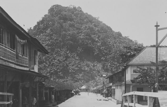


Pemangkat, Indonesia
Pemangkat is a town of 54,259 people in West Kalimantan, Indonesia.
Why visit Pemangkat
Townapedia lists 2 museums and landmarks, 47 places to eat, 10 places to stay and 3 attractions in and around town.
Weather in Pemangkat
Forecast from MET Norway (CC BY 4.0). Full forecast
About Pemangkat
Pemangkat (Chinese: 邦戛, Pinyin: Bāngjiá) is a coastal town and an administrative district (kecamatan) at the mouth of the Sambas River in Sambas Regency, West Kalimantan Province of Indonesia. It is located to the northwest of the provincial capital Pontianak, and had 54,259 inhabitants in mid 2025.
From the Wikipedia article Pemangkat (this version), under CC BY-SA 4.0.
Things to do3

Museums and landmarks2

Tugu Peringatan Korban Perang
Monument and historic site · 1.5 km
Tugu Peringatan Korban Perang (Jepang, Indonesia & Tionghoa)
Jalan Tugu, Pemangkat
Pantai Tanjung Batu
Monument and historic site · 1.7 km
Pemangkat Kota, Pemangkat
Restaurants and cafes47

TomcatAddicted
Bar and pub · Coffee Shop · 1.5 km
Espresso bar
Jalan Pasar Ikan Lama, Pemangkat
Mo-Su 08:00-12:00

Kantin Santai
Restaurant · Regional, Seafood · 1.3 km
Kantin Santai B.A Brotherhood
Jalan Gedung Nasional, Pemangkat

Toko Kopi Harum Manis
Cafe · Coffee Shop · 1.4 km
31 Jalan Mohammad Hambal, Pemangkat
Toko Kopi Hong Kong
Cafe · Coffee Shop · 1.6 km
Coffee Shop
Jalan Mohammad Hambal, Pemangkat
Toko Kopi Wisata
Cafe · Coffee Shop · 1.7 km
Coffee Shop
Jalan Pasar Ikan Lama, Pemangkat
35 more on the map.
Where to stay10

Kost H. Syamsuddin
Motel and hotel · 2.0 km
Extended Stay Hotel
Jolan Tersusan Melati, Pemangkat
Puncak
Motel and hotel · 1.5 km
Padang restaurant
56-58 Jalan Nusantara, Pemangkat
Grand Hotel
Motel and hotel · 1.5 km
69 Jalan Nusantara, Pemangkat
Hotel Duyung Permai 2
Motel and hotel · 2.0 km
Jalan Tugu, Pemangkat
Hotel Kelapa Gading
Motel and hotel · 1.3 km
Jalan Gedung Nasional, Pemangkat
Hotel Masa Pemangkat
Motel and hotel · 1.4 km
Jalan Merdeka, Pemangkat
Natuna Penginapan
Motel and hotel · 1.5 km
49 Jalan Pasar Ikan Lama, Pemangkat
Penginapan Himalaya
Motel and hotel · 1.5 km
Jalan Mohammad Hambal, Pemangkat
Churches and places of worship20
Shopping5
Gas and EV charging1
Schools, colleges and libraries3
Healthcare3
Regional General Hospital
Hospital · 1.6 km
20 Jalan Ahmad Kadir Kasim, Pemangkat
Map of Pemangkat
94 places. The map loads OpenStreetMap tiles when you open it.
Getting there and nearby towns
Singkawang Airport (SKJ) is the nearest airport with scheduled flights listed in OpenStreetMap, 42 km away.
- Singkawang 29 km south, about 29 min by car
- Kota Sambas 43 km northeast, about 43 min by car
- Sungai Raya 52 km south, about 52 min by car
- Bengkayang 64 km southeast, about 1 h by car
Drive times are estimates from straight-line distance, not routes.
Local news
Headlines from INDB.
Reviews, tips and questions
Loading what members have shared...
Sources and licences
- GeoNames (CC BY 4.0): population, coordinates, regions and time zone
- OpenStreetMap contributors (ODbL 1.0): places, airports, map data
- Wikidata (CC0 1.0): elevation, founding date, time zone, website
- Wikimedia Commons (see each image): photos
- Wikipedia (CC BY-SA 4.0): overview and history text
Photo credits
- COLLECTIE TROPENMUSEUM Pemangkat in West-Borneo. TMnr 60044342, Ishikane (Fotograaf/photographer)., CC BY-SA 3.0
- Pabali Musa, Eckosz, CC BY-SA 4.0
Page built November 3, 2026. Spotted a mistake? Tell us or suggest a place.