




Why visit Rishīkesh
Townapedia lists 13 museums and landmarks, 21 parks and trails, 166 places to eat, 166 places to stay and 14 attractions in and around town.
Highlights include Janki bridge, Lakshman Jhula, Beatles Ashram and shiv fair park.
Weather in Rishīkesh
Forecast from MET Norway (CC BY 4.0). Full forecast
About Rishīkesh
Rishikesh or Hrishikesh is a municipal corporation and tehsil of the Dehradun district of the Indian state Uttarakhand. It is situated on the right bank of the Ganges river and is a pilgrimage town for Hindus associated with famous sages and yogis. There are numerous temples and ashrams built along the banks of the river.
From the Wikipedia article Rishikesh (this version), under CC BY-SA 4.0.
Travel tips from other travellers: Rishīkesh on Wikivoyage (CC BY-SA 4.0).
Things to do14









2 more on the map.
Museums and landmarks13


1 more on the map.
Parks, trails and playgrounds21

shiv fair park
Park · 0.6 km
29 adarsh gram sudhama marg, Rishikesh
sunrise-sunset
Dhalwala park
Park · 1.3 km
Dhalwala,Rishikesh,Uttarakhand 249201 Dhalwala park 134,Shridev Suman Marg,Dhalwala,Rishikesh,Uttarakhand 249201, Dhalwala
garden park
Park · 1.7 km
Dhalwala,Rishikesh,Uttarakhand 249201 Dhalwala,Rishikesh,Uttarakhand 249201, Dhalwala
Herbal park
Park · 2.0 km
Herbal Park Rishikesh - Chamba - Tehri Rd Uttarakhand 249137 Herbal Park Rishikesh - Chamba - Tehri Rd Uttarakhand 249137, Rishikesh
9 more on the map.
Restaurants and cafes166

Chatsang Cafe
Cafe · Italian, Mexican, Indian, Chinese, Breakfast · 4.0 km
Laxman Jhula
Mo-Su 07:00-21:30

Shivani's Cafe
Cafe · Italian, Chinese, Pizza, Mexican, Israeli, Healthy Specials · 4.4 km
opposite govt. hospital laxman jhula, rishikesh
Mo-Su 07:30-22:30
Ganga View Cafe Rishikesh
Cafe · Indian · 1.9 km
Ram Jhula
Mo-Su 07:00-22:00
Rudraa
Restaurant · Indian, Italian, Italian Pizza, Tea, Tapas, Sandwich, Pancake, Pizza, Pasta, Noodles, Local, Regional, International, French, Fine Dining, Crepe, Chinese, Coffee Shop, Curry, Diner, Burger, Breakfast · 4.4 km
Laxman Jhula
Mo-Su 06:00-13:00, 14:00-23:00
The Free Spirit Cafe & Hostel
Cafe · Pizza, Burger, Italian, Chinese, Sandwich, Indian, Israeli · 3.9 km
Laxman Jhula, Rishikesh
Mo-Su 10:00-22:00
LA-SO-VA Fresh Kitchen
Restaurant · Italian, Greek, Balkan, Pizza, Deli, Pasta, Local, Diner · 4.1 km
Laxman Jhula
Mo-Su 10:30-14:30
154 more on the map.
History
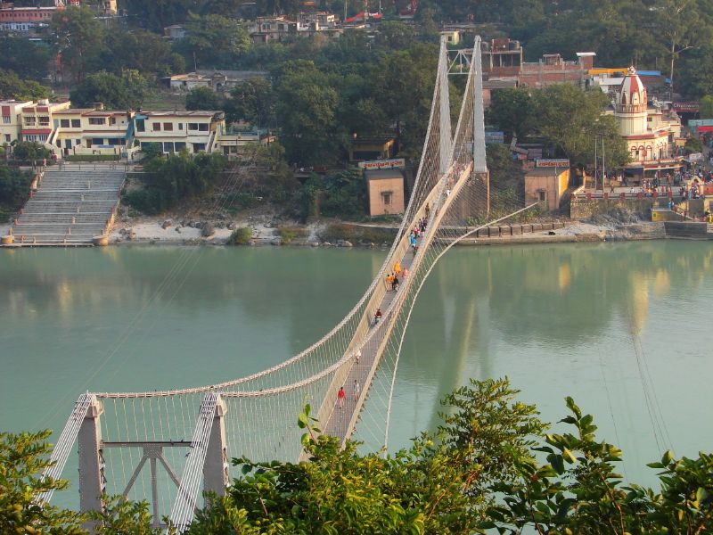
Rishikesh was part of the legendary "Kedarkhand" mentioned in the Skanda Purana. Legends state that Rama did penance here for killing Ravana, the asura king of Lanka. Lakshmana, Rama's younger brother, crossed the Ganges using two jute ropes at the point where the present Lakshman Jhula (लक्ष्मण झूला) suspension bridge stands today. The 248-foot long iron-rope suspension bridge built in 1889 was washed away by flooding in 1924. In 1927, it was replaced by another, stronger bridge built by the United Provinces Public Works Department, connecting the Tapovan, Tehri, and Jonk, Pauri Garhwal districts. Lakshman Jhula collapsed again in 2020. And a much stronger, second in the whole of India, a glass bridge, is being built across the river.
A noted suspension bridge named Ram Jhula was built in 1986 at the nearby Sivananda Nagar.
The Skanda Purana also mentions the site as "Indrakund" where Indra underwent a holy bath to remove a curse.
The Ganges, one of the most sacred rivers to Hindus, flows through Rishikesh in its course from the Shivalik Hills of the Himalayas to the plains of northern India with temples built along the banks Shatrughna Mandir, Bharat Mandir, and Lakshman Mandir are the ancient temples established by Adi Shankaracharya. Shatrughna Temple is near the Ram Jhula suspension bridge, while Lakshman Mandir is situated near the Lakshman Jhula suspension bridge.
From the History section of Rishikesh on Wikipedia, under CC BY-SA 4.0.
Where to stay166
Guest House Savitri Bhawan
Motel and hotel · 3.0 km
120 Shanti Makaan Jonk Rd, near Ram Jhula, Swarg Ashram, Rishikesh, Uttarakhand
Heval River Cottage and Rafting Camp
Campground · 8.4 km
Neelkanth Temple Road, Rattapani Village, Rishikesh
Anand Kashi by the Ganges
Motel and hotel · 14.1 km
23rd Milestone Rishikesh-Badrinath Road tehri Garhwal District Gular Dogi, Uttarakhand, Rishikesh
Garud Chatti River Resort, Book A Camp 003
Campground · 8.4 km
Garud Chatti River Resort Ratta Pani, Neelkanth Temple Rd, Rishikesh
Churches and places of worship47
Sayeed Baba di Mazaar (Grewal Farms)
Place of worship · 9.6 km
Grewal Farms, Chidderwala
Shopping6
Gas and EV charging8
Schools, colleges and libraries19
Rishikesh Yog Nirvana
School · 4.0 km
Hotel Hariyali View Hotel Hariyali View Badrinath Road Laxman Jhula Rishikesh, Uttarakhand, rishikesh
Healthcare21
All India Institute of Medical Sciences, Rishikesh
Hospital · 3.4 km
Map of Rishīkesh
250 places. The map loads OpenStreetMap tiles when you open it.
Getting there and nearby towns
Dehradun Airport (DED) is the nearest airport with scheduled flights listed in OpenStreetMap, 14 km away.
- Birbhaddar 4 km south, about 4 min by car
- Narendranagar 6 km north, about 6 min by car
- Rāīwāla Bara 12 km southwest, about 12 min by car
- Doiwāla 19 km northwest, about 19 min by car
- Haridwar 22 km southwest, about 22 min by car
- Rāipur 30 km northwest, about 30 min by car
- Clement Town 32 km northwest, about 32 min by car
- Dehradun 35 km northwest, about 35 min by car
- Roorkee 47 km southwest, about 47 min by car
- Sahāranpur 74 km west, about 1 h 15 min by car
Drive times are estimates from straight-line distance, not routes.
Local news
Headlines from INDB.
Reviews, tips and questions
Loading what members have shared...
Sources and licences
- GeoNames (CC BY 4.0): population, coordinates, regions and time zone
- OpenStreetMap contributors (ODbL 1.0): places, airports, map data
- Wikidata (CC0 1.0): elevation, founding date, time zone, website, landmarks and historic places
- Wikimedia Commons (see each image): photos
- Wikipedia (CC BY-SA 4.0): overview and history text
Photo credits
- Sunset - Lakshman Jhula, Tylersundance, CC BY-SA 3.0
- Rishikesh, Lakshman Jhula, McKay Savage from London, UK, CC BY 2.0
- Ramjhula - bridge over the Ganga, Asis K. Chatterjee, CC BY-SA 2.0
- AIIMS Rishikesh, Pranjal Garg, CC BY-SA 4.0
- Patna Waterfalls, Rishikesh, India, Ravi Dwivedi, CC BY-SA 4.0
- The Hanging Bridge in Rishikesh(Janki Jhula), Mani.saini96, CC BY-SA 4.0
Page built November 3, 2026. Spotted a mistake? Tell us or suggest a place.