


Tellicherry, India
Tellicherry is a town of 97,201 people in Kerala, India, founded in November 1, 1866.
Why visit Tellicherry
Townapedia lists 6 museums and landmarks, 16 parks and trails, 51 places to eat, 17 places to stay and 9 attractions in and around town.
Highlights include Kannur University, Mahe lighthouse, Gundert Museum and Overbury's Folly.
Weather in Tellicherry
Forecast from MET Norway (CC BY 4.0). Full forecast
About Tellicherry
Thalassery (Malayalam: [t̪ɐlɐʃ(ː)eːɾi] ) (also called Tellicherry) is a city and municipality on the Malabar Coast in Kannur district in the state of Kerala, India, bordered by the districts of Mahe and Kozhikode. Thalassery municipality has a population of just under 100,000 as of 2011 census. Thalassery Heritage City has an area of 23.98 square kilometres (9.26 sq mi). Thalassery has an altitude ranging from 2.5 to 30 metres (8 ft 2 in to 98 ft 5 in) above mean sea-level.
From the Wikipedia article Thalassery (this version), under CC BY-SA 4.0.
Travel tips from other travellers: Tellicherry on Wikivoyage (CC BY-SA 4.0).
Things to do9
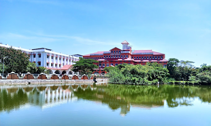
Kannur University
School · 6.1 km
State public university in Kannur, Kerala, India


Muzhappilangad Beach
Beach · 7.3 km
Beach in Kannur district, Keralam, India



Museums and landmarks6


Sub Collector's Bunglaw
Monument and historic site · 0.8 km
Sub Collector's Bunglaw
Tomb of Edward Brennen
Monument and historic site · 0.8 km
Founder of Brennen college, philanthrophist and social reformer. Died 2nd October 1857.

Parks, trails and playgrounds16



Sreerosh play time
Playground · 1.8 km
Mo-Fr 09:00-18:30; Sa 09:00-17:00; PH closed


4 more on the map.
Restaurants and cafes51

restaurent
Restaurant · Sandwich, Coffee Shop, Barbecue, Ice Cream, Cake · 1.8 km
Mo-Fr 09:00-18:30; Sa 09:00-17:00; PH closed

Josgiri Canteen
Restaurant · Indian, Coffee Shop, Curry, Fish And Chips · 2.0 km
Mo-Fr 09:00-12:00,13:30-18:30; Sa 09:00-17:00; closed
Kerala State Road Transport Coporation Canteen
Restaurant · 1.8 km
corona vayal road
Mo,Tu,Th,Fr 09:00-18:30; We 09:00-20:00; Sa 09:00-17:00; PH closed
Restaaurent
Restaurant · Barbecue, Chicken, Fish, Curry, Coffee Shop, Indian · 2.2 km
Mo-Fr 09:00-18:30; Sa 09:00-17:00; PH closed
Savoury
Restaurant · Sandwich, Indian, Coffee Shop, Curry, Fish, Chicken, Barbecue, Arab, Chinese, Ice Cream, Sausage, Seafood · 1.4 km
Mo-Fr 09:00-18:30; Sa 09:00-17:00; PH closed


Daily Icecreams
Ice cream · 1.9 km
Mo-Fr 09:00-12:00,13:30-18:30; Sa 09:00-17:00; PH closed
39 more on the map.
Where to stay17
Churches and places of worship55
Shopping15
Gas and EV charging3
Schools, colleges and libraries67
Healthcare33
Primary Health Centre Dharmadam
Hospital · 4.4 km
Dharmadam-Meloor-mamakunnu road
Map of Tellicherry
250 places. The map loads OpenStreetMap tiles when you open it.
Getting there and nearby towns
Kannur International Airport (CNN) is the nearest airport with scheduled flights listed in OpenStreetMap, 20 km away.
- Erannoli 4 km northeast, about 4 min by car
- Dharmadam 4 km northwest, about 4 min by car
- Katirur 6 km northeast, about 6 min by car
- Pinarāyi 6 km north, about 6 min by car
- Mahē 7 km southeast, about 7 min by car
- Muluppilagadu 7 km northwest, about 7 min by car
- Panoor 9 km east, about 9 min by car
- Irikkūr 27 km north, about 27 min by car
- Kozhikode 64 km southeast, about 1 h by car
- Kanhangad 75 km northwest, about 1 h 15 min by car
Drive times are estimates from straight-line distance, not routes.
Local news
Headlines from INDB.
Reviews, tips and questions
Loading what members have shared...
Sources and licences
- GeoNames (CC BY 4.0): population, coordinates, regions and time zone
- OpenStreetMap contributors (ODbL 1.0): places, airports, map data
- Wikidata (CC0 1.0): elevation, founding date, time zone, website, landmarks and historic places
- Wikimedia Commons (see each image): photos
- Wikipedia (CC BY-SA 4.0): overview and history text
Photo credits
- MAHE LIGHT HOUSE, Prabhupuducherry, CC0
- Muzhappilangad beach12, Ajeeshkumar4u, CC BY-SA 4.0
- Hermann Gundert bungalow, Jameela P., CC BY-SA 4.0
- ThiruvangadTempleFrontView 2832, Primejyothi, CC BY-SA 3.0
- ThalasseryStJosephHigherSecondarySchool, ShajiA, CC BY 4.0
- ThalasseryStadium, Shijaz at English Wikipedia, CC BY-SA 3.0
- Thalassery Light House, Kannur, Vipin Wilfred, CC BY-SA 4.0
- Thalassery fort, Akhil chandran, CC BY-SA 3.0
- Kannur Univerisity Thavakkara Campus, Rahul B Ashok, CC0
- Overbury's foly, Akhil chandran, CC BY-SA 3.0
- Partial view of building, Indira Gandhi Polytechnic College, Mahe, Sachinmtk, CC BY-SA 3.0
- Kannur University, Ks.mini, CC BY-SA 3.0

Page built November 3, 2026. Spotted a mistake? Tell us or suggest a place.