


Inkster, Michigan
Inkster is a city of 25,428 people in Wayne County, Michigan, founded in 1835.
Why visit Inkster
Townapedia lists 8 museums and landmarks, 39 parks and trails, 66 places to eat, 15 places to stay and 3 attractions in and around town.
Highlights include Gateway Bridge (Michigan), State Wayne Theater, Henry Ford Square House and Annapolis Park Historic District.
July is the warmest month, with average highs of 84°F; January lows average 19°F, and about 45 inches of snow fall in a normal year.
Weather in Inkster
Forecast from the National Weather Service. Full forecast
About Inkster
Inkster is a city in Wayne County in the U.S. state of Michigan. A western suburb of Detroit, Inkster is located about 14 miles (23 km) southwest of downtown Detroit. As of the 2020 census, the city had a population of 26,088.
From the Wikipedia article Inkster, Michigan (this version), under CC BY-SA 4.0.
Things to do3
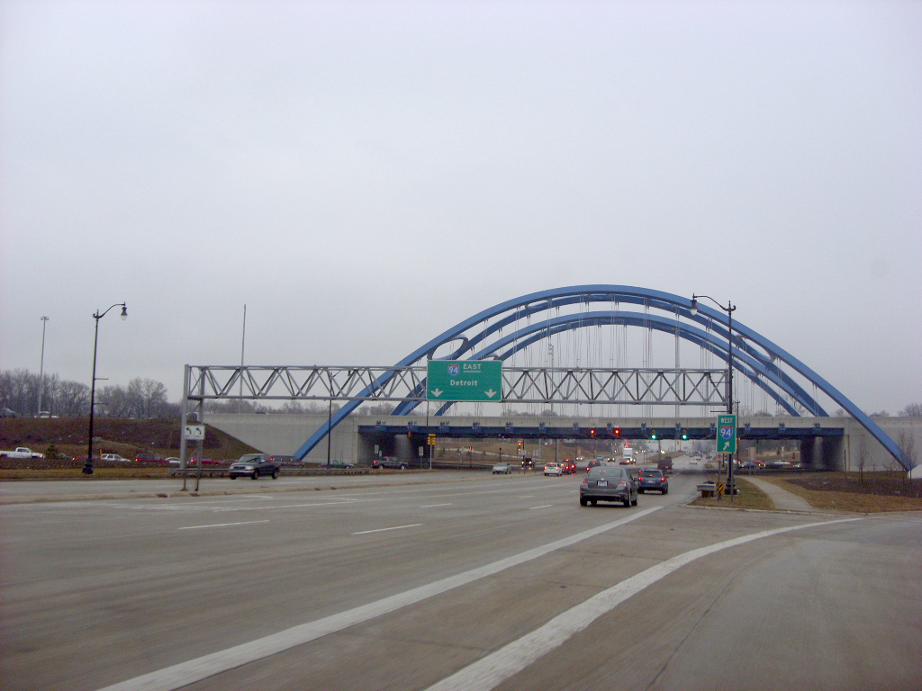
Gateway Bridge (Michigan)
Bridge · 3.2 mi
Tied-arch bridge in Taylor, Michigan

State Wayne Theater
Cinema and theater · 3.5 mi
Movie theater and theater in Wayne, Michigan, United States

Museums and landmarks8

Henry Ford Square House
Monument and historic site · National Register of Historic Places · 2.4 mi
House in Garden City, Michigan

Annapolis Park Historic District
Monument and historic site · National Register of Historic Places · 1.7 mi
Historic district in Westland, Michigan

Commandant's Quarters
Monument and historic site · National Register of Historic Places · 4.0 mi
Building in Michigan, United States

Malcolm X House
Monument and historic site · National Register of Historic Places · 1.2 mi
House in Inkster, Michigan, United States of America

Norwayne Historic District
Monument and historic site · National Register of Historic Places · 2.3 mi
Historic district in Westland, Michigan, United States
Parks, trails and playgrounds39



Hines Park
Park · 3.8 mi
Park in Wayne County, Michigan, United States of America

27 more on the map.
Restaurants and cafes66

Rex's Golden Grill
Restaurant · 2.5 mi
2424 South Telegraph Road, Dearborn
Mo-Sa 07:00-22:00; Su 07:00-21:00

Tim Hortons
Cafe · Coffee Shop · 1.4 mi
27380 Cherry Hill Road, Dearborn Heights
Mo-We 00:00-24:00; Fr-Su 00:00-24:00
Tim Hortons
Cafe · Coffee Shop · 2.3 mi
30121 Ford Road, Garden City
Mo-We 06:00-20:00; Fr-Su 06:00-20:00

Flap Jacks
Diner · American · 1.4 mi
4675 Middlebelt Road, Westland


54 more on the map.
History
The area was originally inhabited by Native Americans. It was settled by non-indigenous people in 1825. A post office named "Moulin Rouge" was established there in December 1857. Robert Inkster, a Scotsman born March 27, 1828, in Lerwick, Shetland, operated a steam sawmill on present-day Inkster Road near Michigan Avenue in the early 1860s.
The post office was renamed "Inkster" in July 1863. The village had a station on the Michigan Central Railroad by 1878. It incorporated as a village in 1926 from parts of Nankin Township and Dearborn Township. After much legal wrangling by the city of Dearborn, Dearborn Township, and the village of Inkster to sort out final borders for these communities, Inkster was incorporated as a city in 1964.
In the 1920s and 1930s, African-Americans working in Henry Ford's Dearborn factories settled in Inkster, as it was closer to their work than Detroit, while they were not allowed to live in Dearborn itself.
As a result of the police beating of Floyd Dent in January 2015, which was caught on a police vehicle's dash cam and released to the public, the victim was awarded $1.4 million. A special assessment of Inkster residents will pay for the settlement, on their July 1, 2015, property tax bill.
From the History section of Inkster, Michigan on Wikipedia, under CC BY-SA 4.0.
Where to stay15
Holiday Inn Express & Suites
Motel and hotel · 2.4 mi
24041 Michigan Avenue, Dearborn
Churches and places of worship7
Shopping14
Gas and EV charging36
Schools, colleges and libraries77
American International Academy Elementary
School · 1.5 mi
300 S Henry Ruff Rd, Westland
American International Academy High Schoolmiddle Schooll
School · 0.5 mi
27100 Avondale St, Inkster
American Montessori Academy Upper Elementary
School · 4.3 mi
30055 Joy Rd, Westland
Healthcare16
Friendly Pharmacy
Clinic and pharmacy · 1.4 mi
29452 Cherry Hill Road, Garden City
Corewell Health Care Center
Clinic and pharmacy · 1.4 mi
2001 Merriman Road, Westland
Get Well Urgent Care
Clinic and pharmacy · 1.9 mi
31451 Cherry Hill Road, Westland
Inkster Westland Urgent Care
Clinic and pharmacy · 1.5 mi
1678 Merriman Road, Westland
Map of Inkster
250 places. The map loads OpenStreetMap tiles when you open it.
Climate by month
Monthly table
| Month | High | Low | Rain | Snow |
|---|---|---|---|---|
| Jan | 32°F | 19°F | 2.2 in | 14.0 in |
| Feb | 35°F | 21°F | 2.1 in | 12.5 in |
| Mar | 46°F | 29°F | 2.4 in | 6.2 in |
| Apr | 59°F | 39°F | 3.3 in | 1.5 in |
| May | 70°F | 50°F | 3.7 in | 0.0 in |
| Jun | 80°F | 60°F | 3.3 in | 0.0 in |
| Jul | 84°F | 64°F | 3.5 in | 0.0 in |
| Aug | 81°F | 63°F | 3.3 in | 0.0 in |
| Sep | 74°F | 56°F | 3.2 in | 0.0 in |
| Oct | 62°F | 44°F | 2.5 in | 0.0 in |
| Nov | 49°F | 34°F | 2.6 in | 1.9 in |
| Dec | 37°F | 25°F | 2.2 in | 8.9 in |
U.S. Climate Normals 1991-2020 for Detroit Metro Ap 72537 (4 mi away), NOAA NCEI.
People and cost of living
American Community Survey 5-year estimates, 2020-2024, U.S. Census Bureau. Estimates have margins of error, larger for small towns.
Disaster history
Wayne County has had 9 federal disaster declarations since 2000, most often for severe storms.
- 2024-02-08: Severe Storms, Tornadoes, And Flooding (Flood)
- 2021-07-15: Severe Storms, Flooding, And Tornadoes (Severe Storm)
- 2020-03-27: Covid-19 Pandemic (Biological)
- 2020-03-13: Covid-19 (Biological)
- 2014-09-25: Severe Storms And Flooding (Flood)
- 2005-09-07: Hurricane Katrina Evacuation (Hurricane)
OpenFEMA disaster declarations summaries.
Getting there and nearby towns
Detroit Metropolitan Airport (DTW) is the nearest airport with scheduled flights listed in OpenStreetMap, 6 miles away.
- Garden City 2 mi northwest, about 4 min by car
- Dearborn Heights 3 mi northeast, about 5 min by car
- Dearborn 6 mi east, about 9 min by car
- Allen Park 6 mi southeast, about 10 min by car
- Farmington 12 mi north, about 19 min by car
- Detroit 13 mi northeast, about 20 min by car
- Farmington Hills 14 mi north, about 22 min by car
- Flat Rock 14 mi south, about 22 min by car
- Hamtramck 15 mi northeast, about 24 min by car
- Ferndale 15 mi northeast, about 24 min by car
Drive times are estimates from straight-line distance, not routes.
Local news
Headlines from INDB, the NEMICO news database.
Reviews, tips and questions
Loading what members have shared...
Sources and licences
- NCES EDGE (Public domain): public schools
- NOAA NCEI U.S. Climate Normals 1991-2020 (Public domain): climate by month
- OpenFEMA (Public domain): disaster declarations
- OpenStreetMap contributors (ODbL 1.0): places, airports, map data
- U.S. Census Bureau (Public domain): population, income, housing, education, commute
- Wikidata (CC0 1.0): elevation, founding date, time zone, website, landmarks and historic places
- Wikimedia Commons (see each image): photos
- Wikipedia (CC BY-SA 4.0): overview and history text
Photo credits
- Michigan Avenue at Beech Daly Road Inkster Michigan, Dwight Burdette, CC BY 3.0
- Holiday Lighting on Michigan Avenue, Inkster, Michigan - panoramio, Dwight Burdette, CC BY 3.0
- Inkster, Michigan (14201307742), Ken Lund from Reno, Nevada, USA, CC BY-SA 2.0
- Inkster, Michigan (14200511031), Ken Lund from Reno, Nevada, USA, CC BY-SA 2.0
- Malcolm X House Inkster MI, Andrew Jameson, CC BY 4.0
- Daly Elementary School, 25824 Michigan Avenue, Inkster, Michigan - panoramio, Dwight Burdette, CC BY 3.0
- U.S. 12, Inkster, Michigan (14017200477), Ken Lund from Reno, Nevada, USA, CC BY-SA 2.0
- U.S. 12, Inkster, Michigan Looking Towards Detroit, Michigan (14203686514), Ken Lund from Reno, Nevada, USA, CC BY-SA 2.0
- Henry Ford Square House, Andrew Jameson, CC BY-SA 3.0
- NorwayneStreetscapeSingleFam, Andrew Jameson, CC BY-SA 3.0
- Annapolis Park A, Andrew Jameson, CC BY-SA 3.0
- Commandants Quarters Dearborn, Andrew Jameson, CC BY-SA 3.0
- State Wayne Theater, Wayne Michigan, Dwight Burdette, CC BY 3.0
- I-94 bridge over US 24, Doug Kerr from Albany, NY, United States, CC BY-SA 2.0
- Brilliant Fall Color - panoramio, Jeffery Roberts, CC BY-SA 3.0
- Community health centers like the Western Wayne Family Health Center are relying on Congress to pass funding so the can continue providing care for thousands of Michigan families! (38924317284), Senator Stabenow, CC BY 2.0
- Michael Butler from The Class, Michaelb7226, CC BY 4.0
- Microsoft Surface Laptop 7, StrangeApparition2011, CC0
- String trimmer head-insert style, StrangeApparition2011, CC BY-SA 4.0
- GPD Win, StrangeApparition2011, CC BY-SA 4.0
- Van Born Road, Westland, Michigan (14180666056), Ken Lund from Reno, Nevada, USA, CC BY-SA 2.0
- Canaan Baptist Church, 26805 Van Born Road, Taylor, Michigan - panoramio, Dwight Burdette, CC BY 3.0
- The Living Word Church of God, 26431 Van Born Road, Taylor, Michigan - panoramio, Dwight Burdette, CC BY 3.0
- Creative common, Donmilla27, CC BY-SA 4.0
- Van Born Baptist Church, 25866 Van Born Road, Dearborn Heights, Michigan - panoramio, Dwight Burdette, CC BY 3.0


Page built October 30, 2026. Spotted a mistake? Tell us or suggest a place.