




Borāzjān, Iran
برازجان
Borāzjān is a city of 110,567 people in Bushehr, Iran, founded in 1928.
Why visit Borāzjān
Townapedia lists 4 museums and landmarks, 20 parks and trails, 25 places to eat and 1 place to stay in and around town.
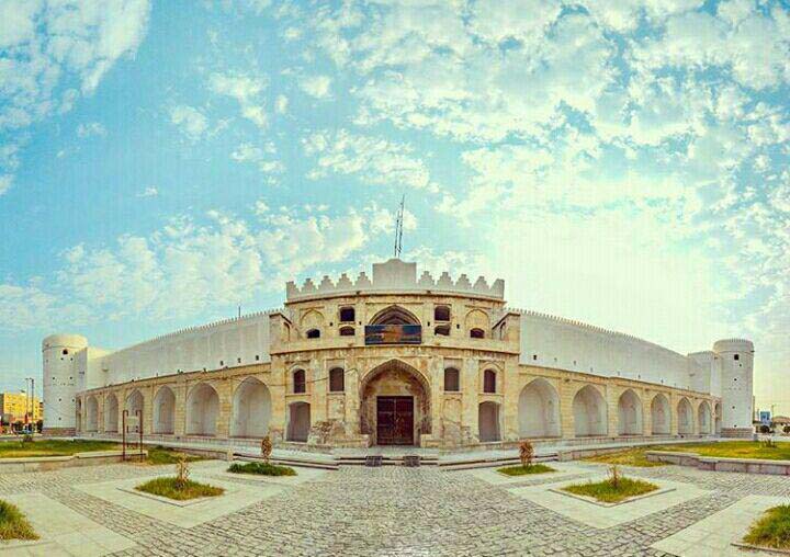
Highlights include Temukan and Borazjan Caravanserai.
Weather in Borāzjān
Forecast from MET Norway (CC BY 4.0). Full forecast
About Borāzjān
Borazjan (Persian: برازجان) is a city in the Central District of Dashtestan County, Bushehr province, Iran, serving as capital of both the county and the district.
From the Wikipedia article Borazjan (this version), under CC BY-SA 4.0.
Museums and landmarks4

Temukan
Monument and historic site · 3.2 km
Historic building in Bushehr Province, Iran



Parks, trails and playgrounds20

8 more on the map.
Restaurants and cafes25

Shahan Cafe
Cafe · Coffee Shop, Cake · 1.1 km
فردوسی, borazjan
08:00-22:00
cafe c کافه سی
Cafe · قهوه کوکی کیک آیس شکلات · 1.5 km
مولوی نهم, برازجان


13 more on the map.
Where to stay1

History
In ancient times, the town was actually by the Persian Gulf. However receding water has pushed the coastline 100 km south to where the city of Bushehr is today. This has left vast amounts of salt covered flats from Borazjan to Bushehr. The land is sparkling white. The salt crystals can be used to extract many minerals such as brine and sodium however such extraction does not exist.
The surrounding landscape was greener in the past however over grazing and drier climate has killed off most of the vegetation. Many wild animals such as deer, boars and coyotes lived in the area, but they have since gone extinct.
The ruins around the city are over three hundred years old. A citadel that was constructed 250 years ago and served as a caravansarai for decades has been transformed into a prison in the last 70 years. Many jewels and treasures have been discovered around the city.
From the History section of Borazjan on Wikipedia, under CC BY-SA 4.0.
Churches and places of worship7
Shopping4
Gas and EV charging3
Schools, colleges and libraries25
Healthcare12
Map of Borāzjān
101 places. The map loads OpenStreetMap tiles when you open it.
Getting there and nearby towns
Bushehr Airport (BUZ) is the nearest airport with scheduled flights listed in OpenStreetMap, 52 km away.
- Deh Qā’ed 4 km northwest, about 4 min by car
- Bondārūz 5 km south, about 5 min by car
- Sar Korreh 8 km south, about 8 min by car
- Rāhdār 9 km northeast, about 9 min by car
- Khowsh Āb 11 km southwest, about 11 min by car
- Jetūţ 12 km northwest, about 12 min by car
- Naz̧ar Āqā 12 km north, about 12 min by car
- Dorūdgāh 13 km northwest, about 13 min by car
- Bushehr 50 km southwest, about 50 min by car
- Kāzerūn 57 km northeast, about 57 min by car
Drive times are estimates from straight-line distance, not routes.
Local news
Headlines from INDB.
Reviews, tips and questions
Loading what members have shared...
Sources and licences
- GeoNames (CC BY 4.0): population, coordinates, regions and time zone
- OpenStreetMap contributors (ODbL 1.0): places, airports, map data
- Wikidata (CC0 1.0): elevation, founding date, time zone, website, landmarks and historic places
- Wikimedia Commons (see each image): photos
- Wikipedia (CC BY-SA 4.0): overview and history text
Photo credits
- ورودی برازجان, ج.طاهری - panoramio, [email protected], CC BY-SA 3.0
- Fort Borazjan, Mohadese akhlaghi, CC BY-SA 4.0
- نمای بیرونی کاروانسرای مشیرالملک برازجان, Amingholami, CC BY-SA 4.0
- کاروانسرای مشیرالملک, مهدی.پ, CC BY-SA 4.0
- فلکه گنجی, ج.طاهری - panoramio, [email protected], CC BY-SA 3.0
- فلکه گنجی , ج.طاهری - panoramio, [email protected], CC BY-SA 3.0
- ورودی برازجان , ج.طاهری - panoramio, [email protected], CC BY-SA 3.0

Page built November 8, 2026. Spotted a mistake? Tell us or suggest a place.