




Why visit Khorramshahr
Townapedia lists 5 museums and landmarks, 22 parks and trails, 19 places to eat, 7 places to stay and 5 attractions in and around town.
Highlights include فروشگاه بزرگ میوه و تره بار طبیعت, First Battle of Khorramshahr and Second Battle of Khorramshahr.
Weather in Khorramshahr
Forecast from MET Norway (CC BY 4.0). Full forecast
About Khorramshahr
Khorramshahr (Persian: خرمشهر; [xoræmˈʃæhɾ]) is a city in the Central District of Khorramshahr County, Khuzestan province, Iran, serving as capital of both the county and the district.
From the Wikipedia article Khorramshahr (this version), under CC BY-SA 4.0.
Travel tips from other travellers: Khorramshahr on Wikivoyage (CC BY-SA 4.0).
Things to do5

فروشگاه بزرگ میوه و تره بار طبیعت
Farm and orchard · 1.8 km
08:00-24:00


Museums and landmarks5

Parks, trails and playgrounds22

No Hunting or Shooting Border Area
Hiking and trails · 6.1 km
با استناد به قانون حفاظت و بهسازی محیط زیست، مرزهای زمینی ایران، به عرض ۷ کیلومتر منطقه شکار و تیراندازی ممنوع هستند. According to...



10 more on the map.
Restaurants and cafes19




7 more on the map.
History
The area where the city exists today was originally under the waters of the Persian Gulf. It later became part of the vast marshlands and the tidal flats at the mouth of the Karun River. The small town known as Piyan, and later Bayan appeared in the area no sooner than the late Parthian time in the first century AD. Whether or not this was located at the same spot where Khurramshahr is today, is highly debatable.
During the Islamic centuries, the Daylamite Buwayhid king, Panah Khusraw Adud ad-Dawlah ordered the digging of a canal to join the Karun River (which at the time emptied independently into the Persian Gulf through the Bahmanshir channel) to the Shatt al-Arab (the joint estuary of the Tigris and Euphrates rivers, known in Iran as Arvand Rud). The extra water made the joint estuary more reliably navigable. The channel thus created was known as the Haffar, Arabic for "excavated," "dugout," which exactly described what the channel was. The Haffar soon became the main channel of the Karun, as it is in the present day.
It was the capital of the Sheikdom of Muhammara, and until 1847, at which time it became Persian territory (according to Article II of the Treaty of Erzurum), Khorramshahr was alternately claimed and occupied by Persia and Turkey. Its ruler at the time was an Arab sheikh.
From the History section of Khorramshahr on Wikipedia, under CC BY-SA 4.0.
Where to stay7
Churches and places of worship13
Shopping10
Gas and EV charging7
Schools, colleges and libraries23
Healthcare8
Map of Khorramshahr
119 places. The map loads OpenStreetMap tiles when you open it.
Getting there and nearby towns
Abadan international Airport (ABD) is the nearest airport with scheduled flights listed in OpenStreetMap, 9 km away.
- Mīnūshahr 10 km south, about 10 min by car
- Abadan 16 km southeast, about 16 min by car
- Dārkhovīn 41 km northeast, about 41 min by car
- Yūkhān 42 km northeast, about 42 min by car
- Chū’ebdeh-ye Yek 44 km southeast, about 44 min by car
- Shādegān 52 km northeast, about 52 min by car
- Arvand Kenār 61 km southeast, about 1 h by car
- Khobeyneh-ye Soflá 88 km north, about 1 h 30 min by car
- Bandar-e Emam Khomeyni 88 km east, about 1 h 30 min by car
- Soveyseh-ye Chahār 88 km northeast, about 1 h 30 min by car
Drive times are estimates from straight-line distance, not routes.
Local news
Headlines from INDB.
Reviews, tips and questions
Loading what members have shared...
Sources and licences
- GeoNames (CC BY 4.0): population, coordinates, regions and time zone
- OpenStreetMap contributors (ODbL 1.0): places, airports, map data
- Wikidata (CC0 1.0): elevation, founding date, time zone, website
- Wikimedia Commons (see each image): photos
- Wikipedia (CC BY-SA 4.0): overview and history text
Photo credits
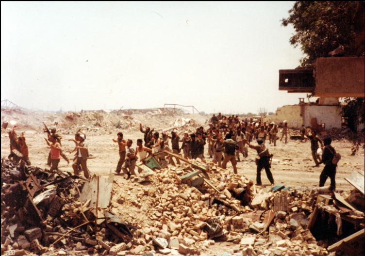
- Khorramshahr, Khuzestan Province, Iran - panoramio, meisam hassanzadeh, CC BY 3.0
- Khorramshahr POWs crop, Capture_in_Khorramshahr.jpg : Unknown derivative work: Eleland ( talk ), GFDL
- Battle of khorramshahr 2, Unknown author Unknown author, Public domain
- Capture in Khorramshahr, Unknown author Unknown author, GFDL
- Battle of khorramshahr 4, Kazem Akhavan, Public domain
- IMG دبیرستان صالحین خرمشهر, Gopelo, CC BY-SA 4.0
- ISS022-E-93178 - View of Earth, Earth Science and Remote Sensing Unit , Lyndon B. Johnson Space Center, Public domain
- Chilothorax lineolatus (Illiger, 1803) Syn.- Aphodius (Chilothorax) lineolatus (Illiger, 1803) (37553480181), Udo Schmidt from Deutschland, CC BY-SA 2.0
- ISS015-E-26851 - View of Kuwait, Earth Science and Remote Sensing Unit , Lyndon B. Johnson Space Center, Public domain


Page built November 8, 2026. Spotted a mistake? Tell us or suggest a place.