


Why visit Shūshtar
Townapedia lists 12 museums and landmarks, 22 parks and trails, 15 places to eat, 9 places to stay and 5 attractions in and around town.
Highlights include Lashkar Bridge, Band-e Kaisar, Saraye Afzal and Historical Hydraulic System.
Weather in Shūshtar
Forecast from MET Norway (CC BY 4.0). Full forecast
About Shūshtar
Shoushtar (Persian: شوشتر, romanized: Shūshtar) is a city in the Central District of Shoushtar County, Khuzestan province, Iran, serving as capital of both the county and the district.
From the Wikipedia article Shoushtar (this version), under CC BY-SA 4.0.
Travel tips from other travellers: Shūshtar on Wikivoyage (CC BY-SA 4.0).
Things to do5



Museums and landmarks12
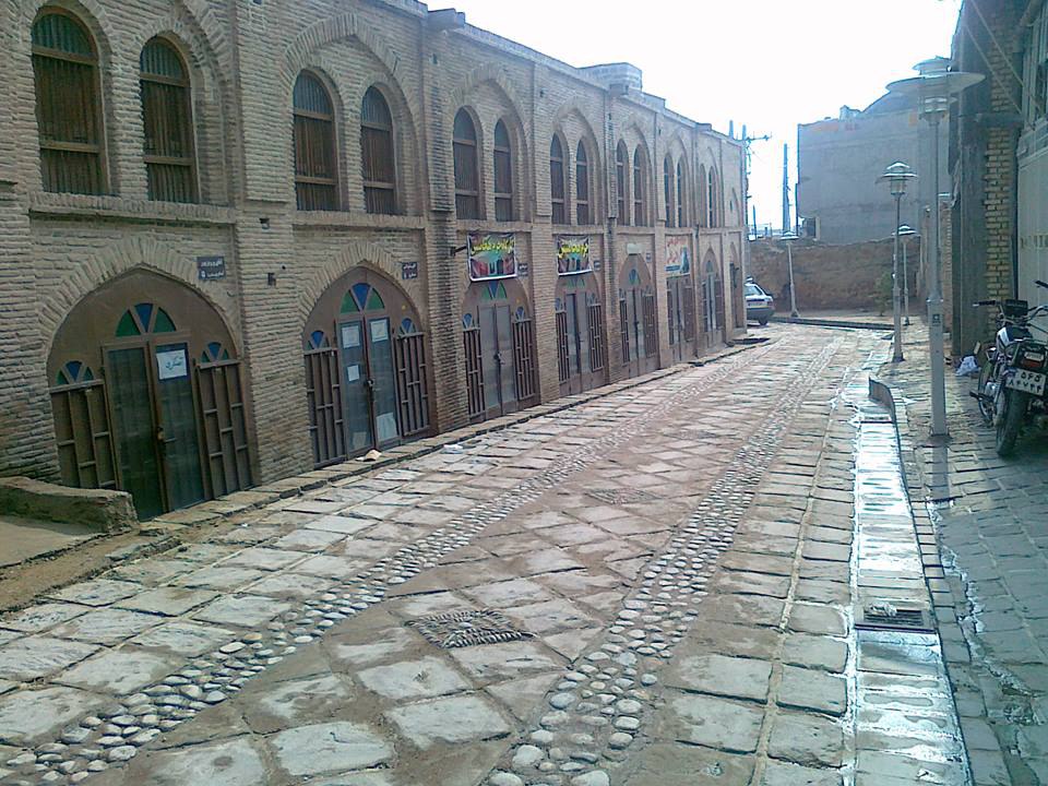
Saraye Afzal
Museum · 0.7 km
فروشگاه صنایع دستی ، و لباس های محلی Handycraft and local clothes shopping
Mo-Fr 08:00-20:00

Historical Hydraulic System
Monument and historic site · 1.1 km
Historical Hydraulic System



Parks, trails and playgrounds22


10 more on the map.
Restaurants and cafes15


Mostoufi House Restaurant
Restaurant · Regional
خانهی مستوفی از جمله بناهای تاریخی واقع در شهرستان شوشتر، یکی از آثار ارزشمند ایران کهن به شمار میآید که کارشناسان بناهای تاریخی، قدمت...
08:00-22:00



3 more on the map.
History
In the Elamite times Shoushtar was known as Adamdun. In the Achaemenid era its name was Šurkutir. According to tradition, Shoushtar was founded by the legendary king Hushang after he built Susa (aka Shoush), and the name "Shoushtar" was a comparative form meaning "more beautiful than Shoush". Josef Marquart also interpreted the name Shoushtar as being derived from Shoush, but with a slightly different meaning, with the suffix "-tar" indicating a direction. The Arabic name of the city, Tustar, is an adaptation of the Persian form Shoushtar.
Shoushtar may be the "Sostra" mentioned by Pliny the Elder. It is also known in Syriac literature as a Nestorian bishopric.
During the Sasanian era, it was an island city on the Karun river and selected to become the summer capital. The river was channeled to form a moat around the city, while bridges and main gates into Shoushtar were built to the east, west, and south. Several rivers nearby are conducive to the extension of agriculture; the cultivation of sugar cane, the main crop, dates back to 226. A system of subterranean channels called Qanats, which connected the river to the private reservoirs of houses and buildings, supplied water for domestic use and irrigation, as well as to store and supply water during times of war when the main gates were closed. Traces of these ghanats can still be found in the crypts of some houses.
From the History section of Shoushtar on Wikipedia, under CC BY-SA 4.0.
Where to stay9
Churches and places of worship19
Shopping5
Gas and EV charging5
Schools, colleges and libraries19
Healthcare9
سونوگرافی_ رادیولوژی گلریزان دیمچه (کدخدازاده)
Clinic and pharmacy · 1.1 km
طالقانی, شوشتر
Map of Shūshtar
120 places. The map loads OpenStreetMap tiles when you open it.
Getting there and nearby towns
Vahdati AFB (DEF) is the nearest airport with scheduled flights listed in OpenStreetMap, 61 km away.
- Takht-e Qeyşar 2 km northeast, about 2 min by car
- Gāvmīshābād 4 km south, about 4 min by car
- Shahrak-e Shahīd Moḩammad Nūrī 5 km south, about 5 min by car
- Sardārān 6 km southwest, about 6 min by car
- Sharāfat 9 km northwest, about 9 min by car
- Dasht-e Bozorg 10 km northeast, about 10 min by car
- Jannat Makān 15 km north, about 15 min by car
- Torkālakī 22 km north, about 22 min by car
- Gotvand 22 km north, about 22 min by car
- Ṣāleḥ Shahr 25 km northwest, about 25 min by car
Drive times are estimates from straight-line distance, not routes.
Local news
Headlines from INDB.
Reviews, tips and questions
Loading what members have shared...
Sources and licences
- GeoNames (CC BY 4.0): population, coordinates, regions and time zone
- OpenStreetMap contributors (ODbL 1.0): places, airports, map data
- Wikidata (CC0 1.0): elevation, founding date, time zone, website, landmarks and historic places
- Wikimedia Commons (see each image): photos
- Wikipedia (CC BY-SA 4.0): overview and history text
Photo credits
- Sushtar Bridge, Ali Afghah, Public domain
- Shah Ali Bridge, MohGan111, CC BY-SA 4.0
- Shushtar bridge, ninara, CC BY-SA 2.0
- Shushtar Historical Hydraulic System Darafsh (6), Darafsh, CC BY-SA 3.0
- Kolah Faranghi Tower-Shooshtar- Khozestan-ID2611- برج کلاهفرنگی شوشتر, Mhsheikholeslami, CC BY-SA 4.0
- Jama Masjid of Shushtar Darafsh (3), Darafsh, CC BY-SA 3.0
- Sh-Mostofi House, Sahariii.mohammadi, CC BY-SA 4.0
- Ghsshk, Sina9985, CC BY-SA 4.0
- Shushtar-Afzal Alley, Mmojtabaa, CC BY-SA 4.0
- Imamzadeh Abdullah Shushtar Darafsh (53), Darafsh, CC BY-SA 3.0
- Shushtar Historical Hydraulic System Panorama, Iman Yari, CC BY-SA 4.0
- Kolah Farangi Shushtar 2016, الهام باقری, CC BY-SA 4.0
- Shushtar Historical Hydraulic System۱, Zibazila, CC BY-SA 4.0
- Iran 3528 (4879580329), Ninara from Helsinki, Finland, CC BY 2.0
- Salasal castle by adel bazmeh, Adel Bazmeh, CC BY-SA 4.0
- Iran 3506 (4880186930), Ninara from Helsinki, Finland, CC BY 2.0
- Iran 3495 (4879579213), Ninara from Helsinki, Finland, CC BY 2.0
- سی سرا در شوشتر - panoramio, matin fattahi, CC BY 3.0
- Shushtar Historical Hydraulic System Darafsh (100), Darafsh, CC BY-SA 3.0
- Mostofi house of shoushtar by Adel Bazmeh, Adel Bazmeh, CC BY-SA 4.0
- اطلاعات قلعه سلاسل - panoramio, matin fattahi, CC BY 3.0
- Shushtar Watermills and waterfalls - panoramio, Alireza Shakernia, CC BY-SA 3.0
- Shushtar Ancient Watermills - panoramio, Alireza Shakernia, CC BY-SA 3.0
- Shooshtar Ancient Water Mills باقی مانده های آسیابهای آبی شوشتر - panoramio, Alireza Shakernia, CC BY-SA 3.0
- Shushtar historical hydrolic system by adel bazmeh, Adel Bazmeh, CC BY-SA 4.0
- Shushtar ancient hydrolic system by adel bazmeh, Adel Bazmeh, CC BY-SA 4.0
- Shushtar Historical Hydraulic, Hessam Saeb, CC BY-SA 4.0
- اسیابهای شوشتر - panoramio (1), auoob farabi, CC BY-SA 3.0
- Irnq044-Shustar-Rzymakie budowle wodne, Wojciech Kocot, CC BY-SA 4.0
- Irnq032-Shustar-Rzymakie budowle wodne, Wojciech Kocot, CC BY-SA 4.0
- آبشار باستانی شوشتر, H.davaran, CC BY-SA 4.0
- Shushtar Historical Hydraulic System, Hessam Saeb, CC BY-SA 4.0
- شوشتر وآبشارهای زیبا - panoramio, matin fattahi, CC BY 3.0
- اسیابهای شوشتر - panoramio, auoob farabi, CC BY-SA 3.0
- Irnq034-Shustar-Rzymakie budowle wodne, Wojciech Kocot, CC BY-SA 4.0
- سازه های آبی شوشتر1, Salehyar, CC BY-SA 4.0
- سازه های آبی شوشتر2, Salehyar, CC BY-SA 4.0
- Shushtar Historical Hydraulic System (UNESCO World Heritage Site) سازههای آبی شوشتر، میراث جهانی یونسکو - panoramio, Hadi Karimi, CC BY 3.0
- Irnq042-Shustar-Rzymakie budowle wodne, Wojciech Kocot, CC BY-SA 4.0
- Iran 3541 (4879580873), Ninara from Helsinki, Finland, CC BY 2.0


Page built November 8, 2026. Spotted a mistake? Tell us or suggest a place.