


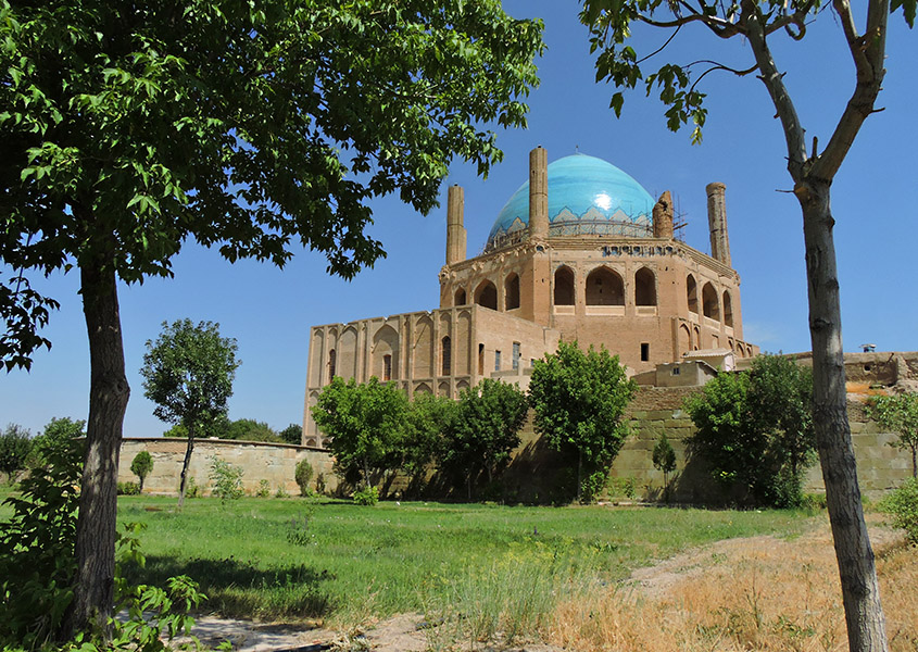


Why visit Solţānīyeh
Townapedia lists 8 museums and landmarks, 4 parks and trails, 10 places to eat and 1 place to stay in and around town.
Highlights include Soltaniyeh Dome and Chelebi Oghlu Mausoleum.
Weather in Solţānīyeh
Forecast from MET Norway (CC BY 4.0). Full forecast
About Solţānīyeh
Soltaniyeh (Persian: سلطانيه) is a city in the Central District of Soltaniyeh County, Zanjan province, Iran, serving as capital of both the county and the district.
From the Wikipedia article Soltaniyeh (this version), under CC BY-SA 4.0.
Travel tips from other travellers: Solţānīyeh on Wikivoyage (CC BY-SA 4.0).
Museums and landmarks8

Soltaniyeh Dome
Monument and historic site
گنبد سلطانیه آرامگاه اُلجایتو است که بین سالهای در ۱۳۰۲ تا ۱۳۱۲ میلادی به دستور خودش در شهر سلطانیه (پایتخت ایلخانیان) ساخته شد و از...
خیابان گنبد, سلطانیه


Chelebi Oghlu Mausoleum
Monument and historic site · 0.8 km
Mausoleum in Soltaniyeh, Iranian national heritage site

Molla Hassan Kashi Mausoleum
Monument and historic site · 1.7 km
Mausoleum in Soltaniyeh, Iranian national heritage site
Parks, trails and playgrounds4


Restaurants and cafes10


Where to stay1

History
Soltaniyeh, located some 240 kilometres (150 mi) to the north-west of Tehran, was built as the capital of Mongol Ilkhanid rulers of Iran in the 14th century. Its name which refers to the Islamic ruler title sultan translates loosely as "the Regal". Soltaniyeh was visited by Ruy González de Clavijo, who reported that the city was a hub of silk exportation.
In 2005, UNESCO listed Soltaniyeh as one of the World Heritage Sites. The road from Zanjan to Soltaniyeh extends until it reaches to the Katale khor cave.
William Dalrymple notes that Öljaitü intended Soltaniyeh to be "the largest and most magnificent city in the world" but that it "died with him" and is now "a deserted, crumbling spread of ruins."
From the History section of Soltaniyeh on Wikipedia, under CC BY-SA 4.0.
Churches and places of worship1
Gas and EV charging2
Schools, colleges and libraries6
Healthcare1
Map of Solţānīyeh
33 places. The map loads OpenStreetMap tiles when you open it.
Getting there and nearby towns
Zanjan International Airport (JWN) is the nearest airport with scheduled flights listed in OpenStreetMap, 54 km away.
- Veyar 10 km southeast, about 10 min by car
- Bū’īn 13 km northeast, about 13 min by car
- Pīr Saqqā 23 km southeast, about 23 min by car
- Chargar 23 km east, about 23 min by car
- Dīzajābād 28 km northwest, about 28 min by car
- Majīdābād 29 km southwest, about 29 min by car
- Sojās 31 km southwest, about 31 min by car
- Hīdaj 36 km southeast, about 36 min by car
- Zanjan 38 km northwest, about 38 min by car
- Abhar 50 km southeast, about 50 min by car
Drive times are estimates from straight-line distance, not routes.
Local news
Headlines from INDB.
Reviews, tips and questions
Loading what members have shared...
Sources and licences
- GeoNames (CC BY 4.0): population, coordinates, regions and time zone
- OpenStreetMap contributors (ODbL 1.0): places, airports, map data
- Wikidata (CC0 1.0): elevation, founding date, time zone, website, landmarks and historic places
- Wikimedia Commons (see each image): photos
- Wikipedia (CC BY-SA 4.0): overview and history text
Photo credits
- مقبره سلطان محمد خدابنده - گنبد سلطانیه, Alireza-Derogar, CC BY-SA 4.0
- Chalapy oghly 2, Mardetanha, CC BY-SA 3.0
- Gonbad Soltaniye, Farzad Yousefian, CC BY-SA 4.0
- Dome of Soltaniyeh jb1, Jb-mhr, CC BY-SA 4.0
- بقعه سلطانيهsoltanieh dome - panoramio, reza mazaheri, CC BY-SA 3.0
- گنبد سلطانیه مهر 1401, Mopanz, CC BY-SA 4.0
- گنبد - سلطانیه, Sorror ghozati, CC BY-SA 4.0
- سلطانیه - آرامگاه سلطان محمد خدابنده, Roksanakhalili, CC BY-SA 4.0
- 040315-Soltanieh-IMG 7568-2, Safa.daneshvar, CC0
- Soltaniye - panoramio (14), ramin shirsavar, CC BY 3.0
- Soltaniyeh dome, Zanjan - panoramio (1), Alen Ištoković, CC BY 3.0
- The mausoleum of Öljaitü in Soltaniyeh, DAVID HOLT from London, England, CC BY-SA 2.0
- بزرگترین گنبد آجری جهان, Erfane79, CC BY-SA 4.0
- Soltaniyeh dome, Zanjan - panoramio, Alen Ištoković, CC BY 3.0
- گنبد سلطانیه زنجان ۱ 02, Mjkhoshnood, CC BY-SA 4.0
- گنبد سلطانیه۹, Mahmoodreza85, CC BY-SA 4.0
- گنبد سلطانیه۲, Mahmoodreza85, CC BY-SA 4.0
- گنبد سلطانیه ۵۴, Mahmoodreza85, CC BY 4.0
- گنبد سلطانیه ۳۷, Mahmoodreza85, CC BY-SA 4.0
- گنبد سلطانیه ۱۳۸, Mahmoodreza85, CC BY 4.0
- گنبد سلطانیه۱۷, Mahmoodreza85, CC BY-SA 4.0
- گنبد سلطانیه ۱۲۴, Mahmoodreza85, CC BY 4.0
- گنبد سلطانیه ۱۰۳, Mahmoodreza85, CC BY 4.0
- گنبد سلطانیه ۶۸, Mahmoodreza85, CC BY 4.0
- گنبد سلطانیه ۱۲۱, Mahmoodreza85, CC BY 4.0
- گنبد سلطانیه ۸۵, Mahmoodreza85, CC BY 4.0
- گنبد سلطانیه۲۴, Mahmoodreza85, CC BY-SA 4.0
- گنبد سلطانیه۵۰, Mahmoodreza85, CC BY-SA 4.0
- گنبد سلطانیه ۹۴, Mahmoodreza85, CC BY 4.0
- گنبد سلطانیه ۱۴۶, Mahmoodreza85, CC BY 4.0
- گنبد سلطانیه۲۵, Mahmoodreza85, CC BY-SA 4.0
- هلال ماه و سیاره زهره بر فراز گنبد سلطانیه, Darabad andromeda, CC BY-SA 4.0
- گنبد سلطانیه ۹۵, Mahmoodreza85, CC BY 4.0
- گنبد سلطانیه ۷۹, Mahmoodreza85, CC BY 4.0
- گنبد سلطانیه زنجان ۱ 04, Mjkhoshnood, CC BY-SA 4.0
- گنبد سلطانیه ۱۲۵, Mahmoodreza85, CC BY 4.0
- گنبد سلطانیه ۱۰۵, Mahmoodreza85, CC BY 4.0
- گنبد سلطانیه ۱۳۷, Mahmoodreza85, CC BY 4.0
- گنبد سلطانیه۴۹, Mahmoodreza85, CC BY-SA 4.0
- گنبد سلطانیه۳۱, Mahmoodreza85, CC BY-SA 4.0


Page built November 8, 2026. Spotted a mistake? Tell us or suggest a place.