


Azumino, Japan
安曇野市
Azumino is a town of 94,222 people in Nagano, Japan, founded in October 1, 2005.
Why visit Azumino
Townapedia lists 75 museums and landmarks, 67 parks and trails, 191 places to eat, 47 places to stay and 28 attractions in and around town.
Highlights include Daio Wasabi Farm, Matsumoto University, Matsumoto Castle and Matsumoto City Timepiece Museum.
Weather in Azumino
Forecast from MET Norway (CC BY 4.0). Full forecast
About Azumino
Azumino (安曇野市, Azumino-shi; Japanese pronunciation: [ä̀.(d͡)zɨ́.mʲí.nó̞(.ɕì)]) is a city located in Nagano Prefecture, Japan. As of 1 March 2019, the city had an estimated population of 97,761 in 39744 households, and a population density of 290 persons per km2. Its total area is 331.78 square kilometres (128.10 sq mi).
From the Wikipedia article Azumino (this version), under CC BY-SA 4.0.
Travel tips from other travellers: Azumino on Wikivoyage (CC BY-SA 4.0).
Things to do28

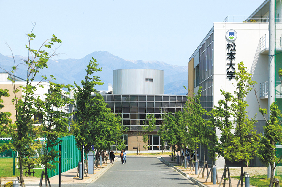
Matsumoto University
School · 7.8 km
Higher education institution in Nagano Prefecture, Japan

Shinshu University
School · 9.3 km
Higher education institution in Nagano Prefecture, Japan






16 more on the map.
Museums and landmarks75


Japan Ukiyo-e Museum
Museum · 7.7 km
Art museum in Matsumoto, Nagano, Japan

Former Kaichi School
Museum · 8.8 km
Meiji-era pseudo-Western style school building in Matsumoto, Japan; first modern school building designated a National Treasure (2019)


Matsumoto City Museum of Archaeology
Museum · 14.7 km
Museum in Matsumoto, Nagano, Japan


63 more on the map.
Parks, trails and playgrounds67





55 more on the map.
Restaurants and cafes191

noodle stand THREE P'S
Restaurant · Asian, Japanese, Noodles · 9.5 km
1 Chome-5-15 Central
Su, We 17:00-23:00; Th 17:30-23:00; Fr-Sa 17:00-00:00

狼煙
Restaurant · Ramen · 9.5 km
21, 松本市
11:30-27:00; Su,PH 11:30-24:00
179 more on the map.
History
The area of present-day Azumino was part of ancient Shinano Province. The area was part of the holdings of Matsumoto Domain during the Edo period. The modern city of Azumino was established on October 1, 2005, by the merger of the town of Akashina (from Higashichikuma District), the towns of Hotaka and Toyoshina, and the villages of Horigane and Misato (all from Minamiazumi District).
From the History section of Azumino on Wikipedia, under CC BY-SA 4.0.
Where to stay47
Churches and places of worship37
Shopping43
Gas and EV charging20
Schools, colleges and libraries49
Healthcare20
Map of Azumino
250 places. The map loads OpenStreetMap tiles when you open it.
Getting there and nearby towns
Shinshu-Matsumoto Airport (MMJ) is the nearest airport with scheduled flights listed in OpenStreetMap, 14 km away.
- Hotaka 6 km north, about 6 min by car
- Matsumoto 9 km southeast, about 9 min by car
- Ōmachi 24 km north, about 24 min by car
- Okaya 29 km southeast, about 29 min by car
- Shimosuwa 30 km southeast, about 30 min by car
- Suwa 34 km southeast, about 34 min by car
- Sakaki 33 km northeast, about 33 min by car
- Tatsuno 35 km south, about 35 min by car
- Ueda 38 km east, about 38 min by car
- Chino 41 km southeast, about 41 min by car
Drive times are estimates from straight-line distance, not routes.
Local news
Headlines from INDB.
Reviews, tips and questions
Loading what members have shared...
Sources and licences
- GeoNames (CC BY 4.0): population, coordinates, regions and time zone
- OpenStreetMap contributors (ODbL 1.0): places, airports, map data
- Wikidata (CC0 1.0): elevation, founding date, time zone, website, landmarks and historic places
- Wikimedia Commons (see each image): photos
- Wikipedia (CC BY-SA 4.0): overview and history text
Photo credits
- Azumino city office, photo: Qurren ( talk ) Taken with Canon IXY 430F (Digital IXUS 245 HS), CC BY-SA 3.0
- Azumino Muncipal Museum of Modern Art, Toyoshina and Toyoshina Exchange and Learning Center Kibo, photo: Qurren ( talk ) Taken with Canon IXY 430F (Digital IXUS 245 HS), CC BY-SA 3.0
- Michinoeki Alps Azumino Horigane no sato, photo: Qurren ( talk ) Taken with Canon IXY 10S, CC BY-SA 3.0
- Azumino city Horigane branch office, photo: Qurren ( talk ) Taken with Canon IXY 10S, CC BY-SA 3.0
- Dosojin (1908 Toyoshina, Azumino) Jindaimojihi 2, photo: Qurren ( talk ) Taken with Canon PowerShot G9 X, CC BY-SA 4.0
- Dosojin (1908 Toyoshina, Azumino) sotaizo, photo: Qurren ( talk ) Taken with Canon PowerShot G9 X, CC BY-SA 4.0
- Dosojin (1908 Toyoshina, Azumino) mojihi, photo: Qurren ( talk ) Taken with Canon PowerShot G9 X, CC BY-SA 4.0
- Dosojin (1908 Toyoshina, Azumino) Jindaimojihi 1, photo: Qurren ( talk ) Taken with Canon PowerShot G9 X, CC BY-SA 4.0
- Dosojin (1908 Toyoshina, Azumino), photo: Qurren ( talk ) Taken with Canon PowerShot G9 X, CC BY-SA 4.0
- Azumino 01, Kuraken, CC BY 2.0
- Azumino city Toyoshina branch office, photo: Qurren ( talk ) Taken with Canon IXY 430F (Digital IXUS 245 HS), CC BY-SA 3.0
- Azumino city office 2, photo: Qurren ( talk ) Taken with Canon IXY 430F (Digital IXUS 245 HS), CC BY-SA 3.0
- Azumino city office 3, photo: Qurren ( talk ) Taken with Canon IXY 430F (Digital IXUS 245 HS), CC BY-SA 3.0
- Azumino city Misato branch office Shirasawa Yasumi monument, photo: Qurren ( talk ) Taken with Canon IXY 10S, CC BY-SA 3.0
- Azumino city Misato Learning Center and Misato Library, photo: Qurren ( talk ) Taken with Canon PowerShot G9 X, CC BY-SA 4.0
- Azumino city Misato branch office 2022-07, photo: Qurren ( talk ) Taken with Canon PowerShot G9 X, CC BY-SA 4.0
- Azumino city Misato branch office, photo: Qurren ( talk ) Taken with Canon IXY 10S, CC BY-SA 3.0
- Azumino city Misato branch office Shirasawa Yasumi's Trees, photo: Qurren ( talk ) Taken with Canon IXY 10S, CC BY-SA 3.0
- 旧上田蚕糸専門学校講堂, Yoit, CC0
- MatsumotoJapanUkiyoeMuseum, Unknown author, Public domain
- 松本市立考古博物館, 深志, CC BY-SA 3.0
- 250424 Former Kaichi School Matsumoto Nagano pref Japan01s3, 663highland, CC BY-SA 4.0
- Matsumoto Castle05s5s4592, 663highland, CC BY 2.5
- Agatanomori03s1920, 663highland, CC BY 2.5
- シネマライツ8(松本市), Capsellanaut, CC BY-SA 4.0
- Hosp, Tomjoy, CC BY-SA 3.0
- Yohashira jinja800, 663highland, CC BY 2.5
- Matsumoto timepiece museum02n4592, 663highland, CC BY 2.5
- 220728 Matsumoto City Museum Japan01s3, 663highland, CC BY-SA 4.0
- Matsumoto City Gymnasium, 禁樹なずな, CC BY-SA 3.0
- Matsumoto city museum of art07nt3200, 663highland, CC BY 2.5
- 松本市野球場 正面入口, クハ419-5, CC BY-SA 3.0
- Jorinji02s1920, 663highland, CC BY 2.5
- Fukashi-jinja haiden, 深志, CC BY-SA 3.0
- 相澤病院外観, Densan2, CC BY-SA 3.0
- Hotaka-jinja kaguraden and haiden, 663highland, CC BY 2.5
- Tukama jinja, Jerry fish tkc, CC BY-SA 3.0
- 鍋冠山(安曇野市), 投稿者, Public domain
- Matsumoto Culture Hall, 禁樹なずな, CC BY-SA 3.0
- Nagano Children's Hospital exterior, hospital of Azumino City, Mukasora, CC BY-SA 3.0
- 長野県護国神社, Towacoco, CC BY-SA 4.0
- Azusa power station, Photographed by Qurren ( talk ), with IXY Digital 10 compact digital camera., CC BY-SA 3.0
- Matsumoto City Mountain and Nature Museum, photo: Qurren ( talk ) Taken with Canon IXY 10S, CC BY-SA 3.0
- MIDORI松本 (49160), Syced, CC0
- Dormy Inn Matsumoto, Syced, CC0
- Matsumoto University, Sasaki keiko, CC BY-SA 3.0
- Fukashi HS No1building, No machine-readable author provided. Tgmsito assumed (based on copyright claims)., CC BY-SA 3.0
- Matsumoto Daiichi High School, 禁樹なずな, CC BY-SA 3.0
- Takahashi Setsuro Art Museum of Azumino 1, photo: Qurren ( talk ) Taken with Canon PowerShot G9 X, CC BY-SA 4.0
- HotakaHigashi Junior High School, Asasa198, CC BY-SA 4.0
- Shuho gaikan, T-matu, CC BY-SA 3.0
- ALPICO PLAZA (2), Tohnass, CC BY-SA 4.0
- 大王山葵農場 Daio Wasabi Farm - panoramio (2), lienyuan lee, CC BY 3.0


Page built November 5, 2026. Spotted a mistake? Tell us or suggest a place.