


Kitakyushu, Japan
北九州市
Kitakyushu is a town of 940,978 people in Fukuoka, Japan, founded in February 10, 1963.
Why visit Kitakyushu
Townapedia lists 47 museums and landmarks, 178 parks and trails, 53 places to eat, 2 places to stay and 20 attractions in and around town.
Highlights include Baiko Gakuin University, Kanmon Bridge, TOTO Museum and Chōshū Domain Shimonoseki Maeda Battery.
Weather in Kitakyushu
Forecast from MET Norway (CC BY 4.0). Full forecast
About Kitakyushu
Kitakyushu (北九州市, Kitakyūshū-shi; Japanese pronunciation: [kʲi̥.ta.kʲɯꜜː.ɕɯː, kʲi̥.ta.kʲɯː.ɕɯꜜː.ɕi]) is a city in Fukuoka Prefecture, Japan. In 2019, Kitakyushu had an estimated population of 940,978, making it the second-largest city in Fukuoka Prefecture and on the island of Kyushu, after the city of Fukuoka. It is one of Japan's 20 designated cities, one of three on Kyushu, and is divided into seven wards.
From the Wikipedia article Kitakyushu (this version), under CC BY-SA 4.0.
Travel tips from other travellers: Kitakyushu on Wikivoyage (CC BY-SA 4.0).
Things to do20

Baiko Gakuin University
School · 14.9 km
Higher education institution in Yamaguchi Prefecture, Japan

Kanmon Bridge
Bridge · 15.8 km
Suspension bridge that crosses the Strait Kanmon Strait and unites the islands of Honshū and Kyūshū of Japan.

Kyushu Dental University
School · 2.3 km
Higher education institution in Fukuoka Prefecture, Japan

Kyushu Institute of Technology
School · 4.8 km
Higher education institution in Fukuoka Prefecture, Japan

Kyushu International University
School · 5.5 km
Higher education institution in Fukuoka Prefecture, Japan

Kyushu Kyoritsu University
School · 13.6 km
Higher education institution in Fukuoka Prefecture, Japan


Nishinippon Institute of Technology
School · 15.7 km
Higher education institution in Fukuoka Prefecture, Japan

Shimonoseki City University
School · 17.0 km
Higher education institution in Yamaguchi Prefecture, Japan


Space World
Monument and historic site · 4.3 km
Former amusement park in Japan
University of Occupational and Environmental Health Japan
School · 13.1 km
Japanese private medical school
8 more on the map.
Museums and landmarks47


Chōshū Domain Shimonoseki Maeda Battery
Monument and historic site · 17.5 km
Fortification in Yamaguchi, Japan

Hiraodai Nature Observation Center
Museum · 11.4 km
Gallery in Kitakyushu, Fukuoka, Japan


Kitakyushu Museum of Natural History & Human History
Museum · 4.3 km
Museum in Kitakyūshū, Fukuoka, Japan





35 more on the map.
Parks, trails and playgrounds178





166 more on the map.
Restaurants and cafes53



41 more on the map.
Where to stay2
Churches and places of worship77
Shopping37
Gas and EV charging6
Schools, colleges and libraries88
Healthcare50
Map of Kitakyushu
250 places. The map loads OpenStreetMap tiles when you open it.
Getting there and nearby towns
Kitakyushu Airport (KKJ) is the nearest airport with scheduled flights listed in OpenStreetMap, 17 km away.
- Miyaodai 13 km west, about 13 min by car
- Nakama 14 km west, about 14 min by car
- Shimonoseki 14 km northeast, about 14 min by car
- Kanda 14 km southeast, about 14 min by car
- Koga 15 km west, about 15 min by car
- Inokura 16 km west, about 16 min by car
- Nōgata 17 km southwest, about 17 min by car
- Yukuhashi 18 km southeast, about 18 min by car
- Fukuoka 49 km southwest, about 49 min by car
- Kurume 67 km southwest, about 1 h by car
Drive times are estimates from straight-line distance, not routes.
Local news
Headlines from INDB.
Reviews, tips and questions
Loading what members have shared...
Sources and licences
- GeoNames (CC BY 4.0): population, coordinates, regions and time zone
- OpenStreetMap contributors (ODbL 1.0): places, airports, map data
- Wikidata (CC0 1.0): elevation, founding date, time zone, website, landmarks and historic places
- Wikimedia Commons (see each image): photos
- Wikipedia (CC BY-SA 4.0): overview and history text
Photo credits
- Kitakyushu montage2, File:Riverwalk building.JPG by User:Masgatotkaca File:Kokura-jo.jpg by User:Manuel Anastácio File:Tanga Ichiba.JPG by User:Kugel File:Mojiko Station 02.JPG by User:Hide-sp File:Kokura Jp night.jpg by..., CC BY-SA 3.0
- Kitakyushu (北九州), Fukuoka Prefecture, Japan 🇯🇵 - Have fun!, Sharon Hahn Darlin, CC BY 4.0
- Kitakyushu (北九州), Fukuoka Prefecture, Japan 🇯🇵 - 55075106742, Sharon Hahn Darlin, CC BY 4.0
- Kitakyushu (北九州), Fukuoka Prefecture, Japan 🇯🇵 - 55076004386, Sharon Hahn Darlin, CC BY 4.0
- Kitakyushu Minamikokura Elementary School, hyolee2, CC BY-SA 4.0
- Kitakyushu (北九州), Fukuoka Prefecture, Japan 🇯🇵 - Beijing style restaurant, Sharon Hahn Darlin, CC BY 4.0
- Kitakyushu (北九州), Fukuoka Prefecture, Japan 🇯🇵 - 55076266814, Sharon Hahn Darlin, CC BY 4.0
- Kitakyushu (北九州), Fukuoka Prefecture, Japan 🇯🇵 - 55076317150, Sharon Hahn Darlin, CC BY 4.0
- Kitakyushu (北九州), Fukuoka Prefecture, Japan 🇯🇵 - 55076321075, Sharon Hahn Darlin, CC BY 4.0
- Kitakyushu (北九州), Fukuoka Prefecture, Japan 🇯🇵 - 55076164148, Sharon Hahn Darlin, CC BY 4.0
- Kyushu dental college, Kugel, Public domain
- Kit front gate, No machine-readable author provided. Historian~commonswiki assumed (based on copyright claims)., CC BY 2.5
- Mutsure Shima Light, Morumoru, CC BY-SA 3.0
- Community cooperation center,NIT, Kugel, Public domain
- Shimonoseki City Univ, Wiki708 at Japanese Wikipedia, CC BY-SA 3.0
- Shirasu toudai, Takayuki, Public domain
- Space World 01, ja:User:Sanjo, CC BY-SA 3.0
- Choshu-Battery-Capture-Shimonoseki-1864, Felice Beato, Public domain
- Hiraodai Nature Observation Center 01, STA3816, CC BY-SA 3.0
- Kitakyusyu museum of natural history and human history, Kugel, CC BY-SA 3.0
- Kyushu Nutrition Welfare University, Kugel, Public domain
- Kitakyushu university, Hactar ( talk ), CC BY-SA 3.0
- Kitakyushu Municipal Museum of Art 20090728, ja:利用者:Wiki591801, CC BY 3.0
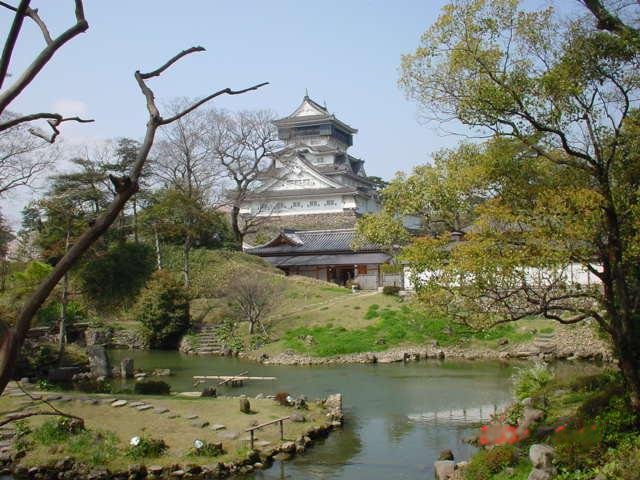
- Kokura castle from the Japanese garden, No machine-readable author provided. Historian~commonswiki assumed (based on copyright claims)., CC BY 2.5
- Kokura Racecourse Main Stand 20080817, Goki ( talk ), CC BY-SA 3.0
- West Japan Industrial Club, No machine-readable author provided. Historian~commonswiki assumed (based on copyright claims)., CC BY 2.5
- AEON Yahata-higashi SC, Kugel, CC BY-SA 3.0
- AEON Tokuriki, アラツク, CC BY-SA 4.0
- Kyushu dental college hospital, Kugel, Public domain
- Kitakyusyu Central Library, 八幡鏡太郎, CC BY 4.0
- Kitakyushu Municipal Medical Center, Kugel, Public domain
- Yomiya Park, Tobata, Kugel, Public domain
- Kokura High School, Kugel, Public domain
- Shinozaki, Ginger55, CC BY-SA 3.0
- Takami Shrine (Kitakyushu), Nissy-KITAQ, CC BY-SA 3.0
- 140721 Matsumoto Seicho Memorial Museum Kitakyushu Japan01bs3, 663highland, CC BY 2.5
- Itouzu shrine, 玄海093, CC BY-SA 3.0
- TOTO (39011274594), tak.wing, CC BY-SA 2.0
- Baiko gakuin Univ, Wiki708 at Japanese Wikipedia, CC BY-SA 3.0
- Kokura-jo-teien, Keramahani, CC BY-SA 4.0
- Yamada park gate, Kugel, Public domain
- Kitakyushu Media Dome, おんさか on Japanese Wikipedia, CC BY-SA 3.0
- Tsukida Elementary School, Nissy-KITAQ, CC BY-SA 3.0
- Petrified wood, Kitakyushu, Kugel, Public domain
- Kurozumi Seichō Park 1, Wakuwaku99, Public domain
- Kyushu Kyoritsu University & Kyushu Women's University, GSI 2010, 国土地理院 (Geospatial Information Authority of Japan), Attribution
- Kitakyushu (北九州), Fukuoka Prefecture, Japan 🇯🇵 - Kokura Catholic Church, Sharon Hahn Darlin, CC BY 4.0


Page built November 4, 2026. Spotted a mistake? Tell us or suggest a place.