


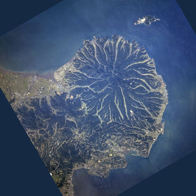


Kunisaki, Japan
国東市
Kunisaki is a town of 26,232 people in Oita, Japan, founded in March 31, 2006.
Why visit Kunisaki
Townapedia lists 17 museums and landmarks, 7 parks and trails, 5 places to eat, 3 places to stay and 4 attractions in and around town.
Highlights include Mount Futago, 千燈岳 and Ankokuji Village Ruins.
Weather in Kunisaki
Forecast from MET Norway (CC BY 4.0). Full forecast
About Kunisaki
Kunisaki (国東市, Kunisaki-shi) is a small coastal city located in Ōita Prefecture, Kyushu, Japan. As of 30 November 2023, the city had an estimated population of 25,721 in 13082 households, and a population density of 81 persons per km2. The total area of the city is 318.10 km2 (122.82 sq mi).
From the Wikipedia article Kunisaki (this version), under CC BY-SA 4.0.
Things to do4


Museums and landmarks17


Ankokuji Village Ruins
Monument and historic site · 1.7 km
Archaeological site in Japan


5 more on the map.
Parks, trails and playgrounds7


Restaurants and cafes5


History
The area of Kunisaki was part of ancient Bungo Province. During the Edo period it was mostly under control of Kitsuki Domain and was ruled by a cadet branch of the Matsudaira clan, with smaller areas administered as tenryō territory under the direct control of the Tokugawa shogunate. After the Meiji restoration, the village of Kunisaki within Higashikunisaki District, Ōita was established on May 1, 1889 with the creation of the modern municipalities system. It was raised to town status on November 8, 1894. The city of Kunisaki was founded on March 31, 2006, from the merger of the former town of Kunisaki, absorbing the towns of Aki, Kunimi and Musashi (all from Higashikunisaki District).
On June 25, 2008, the City of Kunisaki declared itself a 'Nuclear-free Peace City" in wishing the abolition of nuclear weapons and world permanent peace.
From the History section of Kunisaki on Wikipedia, under CC BY-SA 4.0.
Where to stay3
Churches and places of worship13
Shopping4
Gas and EV charging6
Schools, colleges and libraries29
Healthcare1
Map of Kunisaki
89 places. The map loads OpenStreetMap tiles when you open it.
Getting there and nearby towns
Oita Airport (OIT) is the nearest airport with scheduled flights listed in OpenStreetMap, 8 km away.
- Kitsuki 18 km southwest, about 18 min by car
- Bungo-Takada-shi 26 km west, about 26 min by car
- Hiji 27 km southwest, about 27 min by car
- Ōita 38 km south, about 38 min by car
- Beppu 37 km southwest, about 37 min by car
- Yokkaichi 37 km west, about 37 min by car
- Nakatsu 50 km west, about 50 min by car
- Yufu 51 km southwest, about 51 min by car
- Tokuyama 56 km north, about 56 min by car
- Hōfu 57 km north, about 57 min by car
Drive times are estimates from straight-line distance, not routes.
Local news
Headlines from INDB.
Reviews, tips and questions
Loading what members have shared...
Sources and licences
- GeoNames (CC BY 4.0): population, coordinates, regions and time zone
- OpenStreetMap contributors (ODbL 1.0): places, airports, map data
- Wikidata (CC0 1.0): elevation, founding date, time zone, website, landmarks and historic places
- Wikimedia Commons (see each image): photos
- Wikipedia (CC BY-SA 4.0): overview and history text
Photo credits
- Kunisaki city hall, アラツク, CC BY-SA 4.0
- Michinoeki kunisaki, DENCHIkun, Public domain
- Stone Niō Statues, Futago-ji temple, Kunisaki - Mar 19, 2024, Bruno Rijsman, CC BY-SA 2.0
- Kunisaki Peninsula STS068-253-7, NASA, cropped and edited by OiOiO, Public domain
- 文殊仙寺本殿文殊堂, ボス, Public domain
- Oita Prefectural Kunisaki High School, 聖石大戦ぶぅぶぅ, CC BY-SA 4.0
- Rebuilt stilt houses at Ankokuji Village Ruins, K.F., CC BY-SA 4.0
- ISS064-E-45709 - View of Earth, Earth Science and Remote Sensing Unit , Lyndon B. Johnson Space Center, Public domain
- Arrival lobby at Oita Airport.2021-02, Project Kei, CC BY-SA 4.0
- Control tower at Oita Airport, Project Kei, CC BY-SA 4.0
- Airport Surveillance Radar, Project Kei, CC BY-SA 4.0
- Airport surveillance radar towers at Oita Airport, Project Kei, CC BY-SA 4.0
- Oita Kotsu AIR LINER - Ka 969, Project Kei, CC BY-SA 4.0
- Oita Airport Domestic Terminal, Project Kei, CC BY-SA 4.0
- Oita Airport Terminal ObservationDeck, Project Kei, CC BY-SA 4.0
- Oita Airport Terminal ObservationDeck 2, project Kei, CC BY-SA 4.0
- Solaseed Air at Oita Airport 2020-01-01, Project Kei, CC BY-SA 4.0
- Japan Airlines at Oita Airport 2020-08-20, Project Kei, CC BY-SA 4.0
- Loading apron at Oita Airport, Project Kei, CC BY-SA 4.0
- Oita Airport Terminal 2F 2020-08-20, Project Kei, CC BY-SA 4.0
- Oita airport 20220911081933 (52654187159), inunami, CC BY 2.0
- Oita airport 20220911081825 (52654394758), inunami, CC BY 2.0
- Spaceport Oita JAXA Goods Corner, Project Kei, CC BY-SA 4.0
- Space foods Corner, Project Kei, CC BY-SA 4.0
- Spaceport Oita Space foods Corner, Project Kei, CC BY-SA 4.0
- Spaceport Oita Goods Corner, Project Kei, CC BY-SA 4.0
- Oita Airport Terminal Building, Oita trip, CC BY-SA 3.0
- JA14JJ at Oita Airport 20140224, Oita trip, CC BY-SA 3.0
- Monument of the Oita Airport, Oita trip, CC BY-SA 3.0
- Oita Airport control tower building, Oita trip, CC BY-SA 3.0
- Oita Airport boarding bridge, Oita trip, CC BY-SA 3.0
- Flight simulation game at Oita Airport, Project Kei, CC BY-SA 4.0
- Flight simulation game at Oita Airport (rudder pedals), Project Kei, CC BY-SA 4.0
- Dream Port Oita, Project Kei, CC BY-SA 4.0
- Oita airport , 大分空港 - panoramio, z tanuki, CC BY 3.0
- Oita airport 20220911081055 (52653915291), inunami, CC BY 2.0
- Oita airport 20220911081023 (52653419437), inunami, CC BY 2.0
- Oita Airport parking lot, Project Kei, CC BY-SA 4.0
- Oita airport 20220911080424 (52654395188), inunami, CC BY 2.0
- Oita Airport International Terminal, Project Kei, CC BY-SA 4.0


Page built November 5, 2026. Spotted a mistake? Tell us or suggest a place.