


Matsushige, Japan
松茂町
Matsushige is a town of 14,583 people in Tokushima, Japan, founded in August 1, 1961.
Why visit Matsushige
Townapedia lists 3 museums and landmarks, 4 parks and trails, 28 places to eat, 9 places to stay and 1 attraction in and around town.
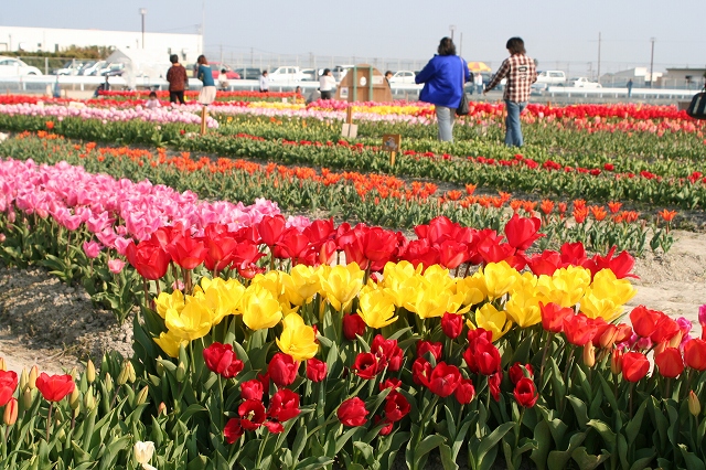
Highlights include Shikoku Saburo Bridge, 松茂町歴史民俗資料館・人形浄瑠璃芝居資料館, 北島チューリップ公園 and 月見ヶ丘海浜公園.
Weather in Matsushige
Forecast from MET Norway (CC BY 4.0). Full forecast
About Matsushige
Matsushige (松茂町, Matsushige-chō) is a town located in Itano District, Tokushima Prefecture, Japan. As of 1 April 2022, the town had an estimated population of 14,770 in 6,794 households and a population density of 1000 persons per km2. The total area of the town is 14.24 square kilometres (5.50 sq mi). Matsushige is the location of Tokushima Airport, from where domestic flights depart for various other Japanese cities.
From the Wikipedia article Matsushige, Tokushima (this version), under CC BY-SA 4.0.
Things to do1

Museums and landmarks3


Parks, trails and playgrounds4




Restaurants and cafes28

うりぼう
Restaurant · Noodle · 2.6 km
徳島市市川内町平石古田86-6
Mo-Su 11:00-21:00

16 more on the map.
History
As with all of Tokushima Prefecture, the area of Matsushige was part of ancient Awa Province. It was noted for ocean-borne shipping, especially of timber, from Tosa Province to the Kinai region. During the Edo period, the area was part of the holdings of Tokushima Domain ruled by the Hachisuka clan from their seat at Tokushima Castle. The village of Matsushige was established within Itano District, Tokushima with the creation of the modern municipalities system on 1 October 1889. It was raised to town status on 1 August 1961.
From the History section of Matsushige, Tokushima on Wikipedia, under CC BY-SA 4.0.
Where to stay9
Churches and places of worship32
Shopping16
Gas and EV charging5
Schools, colleges and libraries16
Healthcare11
Map of Matsushige
125 places. The map loads OpenStreetMap tiles when you open it.
Getting there and nearby towns
Tokushima Airport (TKS) is the nearest airport with scheduled flights listed in OpenStreetMap, 2 km away.
- Komatsushimachō 15 km south, about 15 min by car
- Ishii 15 km southwest, about 15 min by car
- Minamiawaji 24 km northeast, about 24 min by car
- Higashikagawa 24 km west, about 24 min by car
- Anan 25 km south, about 25 min by car
- Awa 28 km west, about 28 min by car
- Yoshinogawa 29 km west, about 29 min by car
- Sumoto 37 km northeast, about 37 min by car
- Wakimachi 40 km west, about 40 min by car
- Mima 42 km west, about 42 min by car
Drive times are estimates from straight-line distance, not routes.
Local news
Headlines from INDB.
Reviews, tips and questions
Loading what members have shared...
Sources and licences
- GeoNames (CC BY 4.0): population, coordinates, regions and time zone
- OpenStreetMap contributors (ODbL 1.0): places, airports, map data
- Wikidata (CC0 1.0): elevation, founding date, time zone, website, landmarks and historic places
- Wikimedia Commons (see each image): photos
- Wikipedia (CC BY-SA 4.0): overview and history text
Photo credits
- Matsushige town hall, アラツク, CC BY-SA 4.0
- NakakiraiKannondou(Matsushige,Tokushima) 20190324 17, Shizuha, CC BY-SA 4.0
- NakakiraiKannondou(Matsushige,Tokushima) 20190324 16, Shizuha, CC BY-SA 4.0
- NakakiraiKannondou(Matsushige,Tokushima) 20190324 25, Shizuha, CC BY-SA 4.0
- NakakiraiKannondou(Matsushige,Tokushima) 20190324 14, Shizuha, CC BY-SA 4.0
- NakakiraiKannondou(Matsushige,Tokushima) 20190324 11, Shizuha, CC BY-SA 4.0
- NakakiraiKannondou(Matsushige,Tokushima) 20190324 15, Shizuha, CC BY-SA 4.0
- NakakiraiKannondou(Matsushige,Tokushima) 20190324 01, Shizuha, CC BY-SA 4.0
- NakakiraiKannondou(Matsushige,Tokushima) 20190324 02, Shizuha, CC BY-SA 4.0
- NakakiraiKannondou(Matsushige,Tokushima) 20190324 18, Shizuha, CC BY-SA 4.0
- NakakiraiKannondou(Matsushige,Tokushima) 20190324 03, Shizuha, CC BY-SA 4.0
- NakakiraiKannondou(Matsushige,Tokushima) 20190324 04, Shizuha, CC BY-SA 4.0
- NakakiraiKannondou(Matsushige,Tokushima) 20190324 12, Shizuha, CC BY-SA 4.0
- NakakiraiKannondou(Matsushige,Tokushima) 20190324 13, Shizuha, CC BY-SA 4.0
- Shikoku Saburo Bridge 20210110, 新幹線, CC BY-SA 4.0
- Kitajima Tulip Park 01, タクドラの金太郎 from Tokushima, Japan., CC BY 2.1 jp
- Kitajima Town Kitajima Elementary School, Mr. Udon, CC BY-SA 3.0
- Tokushima City Kawauchi-Kita elementary school, KishujiRapid, CC BY-SA 4.0
- Hie-jinja, Sorrysorry, Public domain
- Kitajima Town Kitajima Lower Secondary School, Mr. Udon, CC BY-SA 3.0
- Kitajima Town Kitajimakita Elementary School, Mr. Udon, CC BY-SA 3.0
- Matsushige Town Matsushige Lower Secondary School, Mr. Udon, CC BY-SA 3.0
- Matsushige Town Nagahara Elementary School, Mr. Udon, CC BY-SA 3.0
- 松茂町歴史民俗資料館・人形浄瑠璃芝居資料館 20210504, Shizuha, CC BY-SA 4.0
- Matsushigate ファブスペース 全景, Shizuha, CC BY-SA 4.0
- Matsushigate ファブスペース 07, Shizuha, CC BY-SA 4.0
- Matsushigate ファブスペース 06, Shizuha, CC BY-SA 4.0
- Matsushigate ファブスペース 08, Shizuha, CC BY-SA 4.0
- Matsushigate ファブスペース 04, Shizuha, CC BY-SA 4.0
- Matsushigate ファブスペース 05, Shizuha, CC BY-SA 4.0
- Matsushigate 売店, Shizuha, CC BY-SA 4.0
- Matsushigate コワーキングスペース 01, Shizuha, CC BY-SA 4.0
- Matsushigate ファブスペース 03, Shizuha, CC BY-SA 4.0
- Matsushigate ファブスペース 02, Shizuha, CC BY-SA 4.0
- Matsushigate キッチンスタジオ, Shizuha, CC BY-SA 4.0
- Matsushigate ファブスペース 01, Shizuha, CC BY-SA 4.0
- Matsushigate 正面右方向, Shizuha, CC BY-SA 4.0
- 松茂町地域コミュニティバス 松茂係長 正面方向, Shizuha, CC BY-SA 4.0
- Matsushigate 建物正面, Shizuha, CC BY-SA 4.0
- 松茂町地域コミュニティバス 松茂係長 背面方向, Shizuha, CC BY-SA 4.0


Page built November 5, 2026. Spotted a mistake? Tell us or suggest a place.