
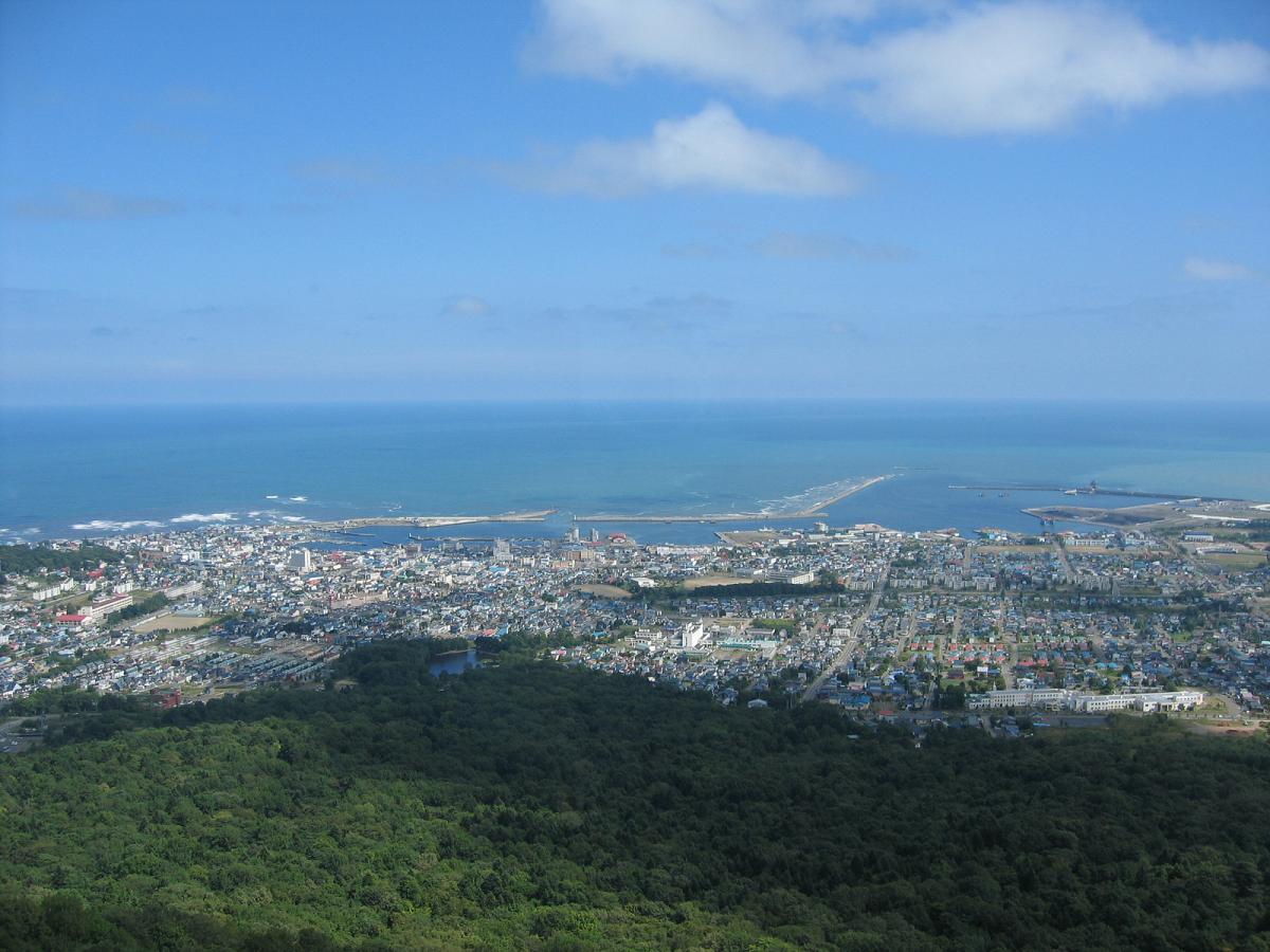


Mombetsu, Japan
紋別市
Mombetsu is a town of 22,983 people in Hokkaido, Japan, founded in July 1, 1954.
Why visit Mombetsu
Townapedia lists 6 museums and landmarks, 8 parks and trails, 5 places to eat, 5 places to stay and 6 attractions in and around town.
Highlights include Okhotsk Tokkari Center, Monbatsu Lighthouse, Mombetsu Municipal Museum and 紋別市立博物館.
Weather in Mombetsu
Forecast from MET Norway (CC BY 4.0). Full forecast
About Mombetsu
Monbetsu (紋別市, Monbetsu-shi) is a city located in Okhotsk Subprefecture, Hokkaido, Japan; on the Sea of Okhotsk. The name comes from Ainu Mopet (Quiet River), Ainu "-pet" would be interpreted "-betsu" in Japanese as well of other city names in Hokkaido.
From the Wikipedia article Monbetsu, Hokkaido (this version), under CC BY-SA 4.0.
Travel tips from other travellers: Mombetsu on Wikivoyage (CC BY-SA 4.0).
Things to do6

Okhotsk Tokkari Center
Zoo and aquarium · 2.7 km
Seal rehabilitation center in Japan




Museums and landmarks6





Parks, trails and playgrounds8


Restaurants and cafes5



History
1909: Mobetsu Village (藻鼈村) and Monbetsu Village merge to form Monbetsu Village
July 1, 1954: Shokotsu Village (渚滑村) and Kamishokotsu Village (上渚滑村) merge with Monbetsu to form the city of Monbetsu
From the History section of Monbetsu, Hokkaido on Wikipedia, under CC BY-SA 4.0.
Where to stay5
Churches and places of worship3
Shopping3
Gas and EV charging7
Schools, colleges and libraries14
Healthcare8
Map of Mombetsu
65 places. The map loads OpenStreetMap tiles when you open it.
Getting there and nearby towns
Monbetsu Airport (MBE) is the nearest airport with scheduled flights listed in OpenStreetMap, 7 km away.
- Okoppe 23 km northwest, about 23 min by car
- Kamiyūbetsu Tonden Shigaichi 30 km southeast, about 30 min by car
- Takinoue 29 km southwest, about 29 min by car
- Nishiokoppe 32 km west, about 32 min by car
- Engaru 37 km southeast, about 37 min by car
- Ōmu 40 km northwest, about 40 min by car
- Nayoro 71 km west, about 1 h 15 min by car
- Kitami 75 km southeast, about 1 h 15 min by car
- Minamishibetsuchō 81 km west, about 1 h 15 min by car
- Motomachi 83 km southeast, about 1 h 30 min by car
Drive times are estimates from straight-line distance, not routes.
Local news
Headlines from INDB.
Reviews, tips and questions
Loading what members have shared...
Sources and licences
- GeoNames (CC BY 4.0): population, coordinates, regions and time zone
- OpenStreetMap contributors (ODbL 1.0): places, airports, map data
- Wikidata (CC0 1.0): elevation, founding date, time zone, website, landmarks and historic places
- Wikimedia Commons (see each image): photos
- Wikipedia (CC BY-SA 4.0): overview and history text
Photo credits
- Monbetsu panorama, Snap55, CC BY 3.0
- Mombetsu bus terminal01, 221.20 ( talk ), Public domain
- Mombetsu city museum, Ozizo, Public domain
- Monbetsu lighthouse, 切干大根, CC BY-SA 4.0
- 69644 shokotsu 20200821, Misei sen, CC BY-SA 4.0
- Gatesofheaven, Aguhiyorifan20, CC0
- Hokkaido Mombetsu High School, Ozizo, Public domain
- Monbetsu hospital 20150425, Mee-san, CC BY 3.0
- AEON-Monbetsu01, RJD, CC BY 3.0
- Hokuyu-Lucky.CITY-Monbetsu, RJD, CC BY 3.0
- Hokumon bus Ki200F 0189, 221.20 ( talk ), Public domain
- Monbetsu 20201008105146 (50849379956), inunami, CC BY 2.0
- Monbetsu 20201008104154 (50849470822), inunami, CC BY 2.0
- 夢小路 (2425095697), Patricia Tse, CC BY-SA 2.0
- 紋別公園(7月) - panoramio, pierrot_2012, CC BY-SA 3.0
- Monbetsu 20201008113522 (50848644483), inunami, CC BY 2.0
- Monbetsu 20201008112605 (50848646298), inunami, CC BY 2.0
- Monbetsu 20201008110839 (50849468047), inunami, CC BY 2.0
- Monbetsu 20201008111450 (50848649103), inunami, CC BY 2.0
- Monbetsu 20201008111444 (50849376511), inunami, CC BY 2.0
- Monbetsu 20201008111432 (50848650303), inunami, CC BY 2.0
- Engaru shinyoukinko monbetsushiten, Sengoku40, CC BY-SA 3.0
- Monbetsu Biomass Power Plant 202605, Sashimiteishoku, CC0
- ガリンコ号2出航 - panoramio, hj695gz, CC BY 3.0
- 初代ガリンコ号 - panoramio, hj695gz, CC BY 3.0
- ガリンコ号2 - panoramio, hj695gz, CC BY 3.0
- 1 Kaiyōkōen, Monbetsu-shi, Hokkaidō 094-0031, Japan - panoramio, usui.mobile, CC BY-SA 3.0
- 1 Kaiyōkōen, Monbetsu-shi, Hokkaidō 094-0031, Japan - panoramio (2), usui.mobile, CC BY-SA 3.0
- 1 Kaiyōkōen, Monbetsu-shi, Hokkaidō 094-0031, Japan - panoramio (1), usui.mobile, CC BY-SA 3.0
- 1 Kaiyōkōen, Monbetsu-shi, Hokkaidō 094-0031, Japan - panoramio (3), usui.mobile, CC BY-SA 3.0
- 1 Kaiyōkōen, Monbetsu-shi, Hokkaidō 094-0031, Japan - panoramio (5), usui.mobile, CC BY-SA 3.0
- 1 Kaiyōkōen, Monbetsu-shi, Hokkaidō 094-0031, Japan - panoramio (4), usui.mobile, CC BY-SA 3.0
- 氷海展望塔オホーツクタワー - panoramio, Mamusi Taka, CC BY-SA 3.0
- がりんこ号 - panoramio, Mamusi Taka, CC BY-SA 3.0
- Manhole Monbetsu, VKaeru, CC BY-SA 3.0
- オホーツクタワー - panoramio, hj695gz, CC BY 3.0
- キタキツネ - panoramio, おおだいららいら, CC BY 3.0
- オホーツクタワー - panoramio - hj695gz, hj695gz, CC BY 3.0
- Michinoeki Okhotsk monbetsu, Him56, CC BY-SA 3.0
- 20100811渚滑駅跡パークゴルフ場, Kei365, CC BY-SA 3.0


Page built November 5, 2026. Spotted a mistake? Tell us or suggest a place.