


Morioka, Japan
盛岡市
Morioka is a regional capital of 290,700 people in Iwate, Japan, founded in April 1, 1889.
Why visit Morioka
Townapedia lists 42 museums and landmarks, 34 parks and trails, 282 places to eat, 24 places to stay and 11 attractions in and around town.
Highlights include Iwate Medical University, Iwate Prefectural University, Iwate Museum of Art and Yubunezawa Stone Circle.
Weather in Morioka
Forecast from MET Norway (CC BY 4.0). Full forecast
About Morioka
Morioka (盛岡市, Morioka-shi; Japanese pronunciation: [mò̞.ɾʲí.ò̞.kä̀, -ó̞.kä́.ɕì]) is the capital city of Iwate Prefecture located in the Tōhoku region of northern Japan. As of 1 August 2023, the city had an estimated population of 283,981 in 132,719 households, and a population density of 320 per square kilometre (830/sq mi). The total area of the city is 886.47 square kilometres (342.27 sq mi).
From the Wikipedia article Morioka (this version), under CC BY-SA 4.0.
Travel tips from other travellers: Morioka on Wikivoyage (CC BY-SA 4.0).
Things to do11

Iwate Medical University
School · 0.6 km
Higher education institution in Iwate Prefecture, Japan

Iwate Prefectural University
School · 11.3 km
Higher education institution in Iwate Prefecture, Japan

Iwate University
School · 2.0 km
Higher education institution in Iwate Prefecture, Japan



Museums and landmarks42

Iwate Museum of Art
Museum · 2.3 km
Art museum in Morioka, Iwate, Japan

Yubunezawa Stone Circle
Monument and historic site · 10.1 km
Archaeological site in Takizawa, Iwate, Japan






30 more on the map.
Parks, trails and playgrounds34
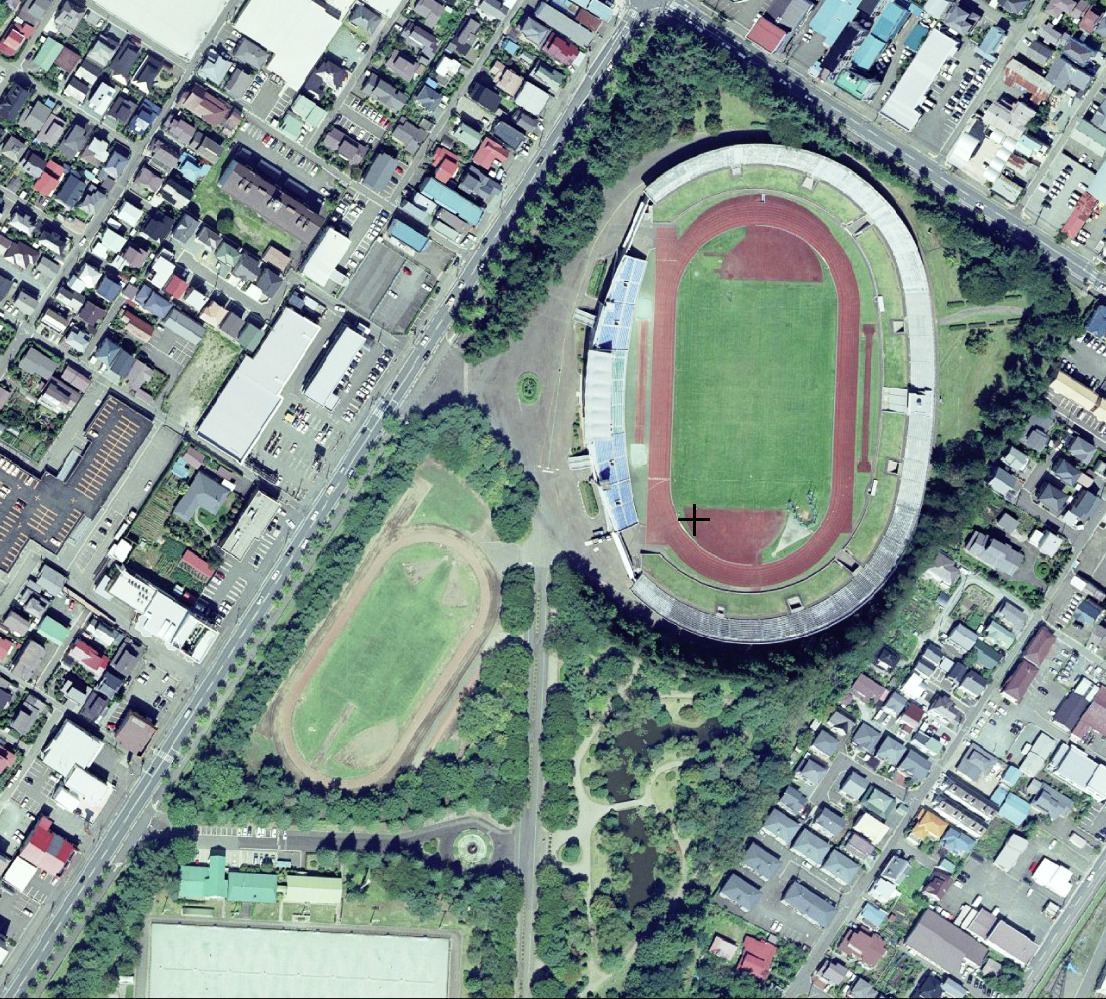
Iwate Morioka Stadium
Park · 5.0 km
Multi-use stadium in Morioka, Iwate, Japan



22 more on the map.
Restaurants and cafes282







270 more on the map.
Where to stay24
Churches and places of worship55
Shopping26
Gas and EV charging1
Schools, colleges and libraries35
Healthcare54
Map of Morioka
250 places. The map loads OpenStreetMap tiles when you open it.
Getting there and nearby towns
Hanamaki Airport (HNA) is the nearest airport with scheduled flights listed in OpenStreetMap, 30 km away.
- Yahaba 10 km south, about 10 min by car
- Takizawa 12 km north, about 12 min by car
- Shizukuishi 14 km west, about 14 min by car
- Hizume 17 km south, about 17 min by car
- Hachimantai 22 km north, about 22 min by car
- Numakunai 30 km north, about 30 min by car
- Semboku 35 km west, about 35 min by car
- Hanamaki 35 km south, about 35 min by car
- Kuzumaki 45 km northeast, about 45 min by car
- Kitakami 46 km south, about 46 min by car
Drive times are estimates from straight-line distance, not routes.
Local news
Headlines from INDB.
Reviews, tips and questions
Loading what members have shared...
Sources and licences
- GeoNames (CC BY 4.0): population, coordinates, regions and time zone
- OpenStreetMap contributors (ODbL 1.0): places, airports, map data
- Wikidata (CC0 1.0): elevation, founding date, time zone, website, landmarks and historic places
- Wikimedia Commons (see each image): photos
- Wikipedia (CC BY-SA 4.0): overview and history text
Photo credits
- Morioka and Mount Iwate and River Kitakami in May 2019, Yuichi Shiraishi, CC BY-SA 4.0
- 171103 Morioka Castle Morioka Iwate pref Japan17bs3, 663highland, CC BY-SA 4.0
- 171103 Morioka Castle Morioka Iwate pref Japan20s3, 663highland, CC BY-SA 4.0
- 171103 Morioka Castle Morioka Iwate pref Japan25n, 663highland, CC BY-SA 4.0
- 171103 Morioka Castle Morioka Iwate pref Japan09n, 663highland, CC BY-SA 4.0
- 171103 Morioka Castle Morioka Iwate pref Japan11n, 663highland, CC BY-SA 4.0
- 171103 Morioka Castle Morioka Iwate pref Japan04n, 663highland, CC BY-SA 4.0
- 171103 Morioka Castle Morioka Iwate pref Japan05n, 663highland, CC BY-SA 4.0
- 171103 Morioka Castle Morioka Iwate pref Japan21n, 663highland, CC BY-SA 4.0
- 171103 Morioka Castle Morioka Iwate pref Japan10n, 663highland, CC BY-SA 4.0
- 171103 Morioka Castle Morioka Iwate pref Japan06n, 663highland, CC BY-SA 4.0
- 171103 Morioka Castle Morioka Iwate pref Japan12n, 663highland, CC BY-SA 4.0
- 171103 Morioka Castle Morioka Iwate pref Japan15s3, 663highland, CC BY-SA 4.0
- 171103 Morioka Castle Morioka Iwate pref Japan13n, 663highland, CC BY-SA 4.0
- 171103 Morioka Castle Morioka Iwate pref Japan19s3, 663highland, CC BY-SA 4.0
- 171103 Morioka Castle Morioka Iwate pref Japan08n, 663highland, CC BY-SA 4.0
- 171103 Morioka Castle Morioka Iwate pref Japan18n, 663highland, CC BY-SA 4.0
- 171103 Morioka Castle Morioka Iwate pref Japan03n, 663highland, CC BY-SA 4.0
- 171103 Morioka Castle Morioka Iwate pref Japan27n, 663highland, CC BY-SA 4.0
- 171103 Morioka Castle Morioka Iwate pref Japan07n, 663highland, CC BY-SA 4.0
- 171103 Morioka Castle Morioka Iwate pref Japan26n, 663highland, CC BY-SA 4.0
- 171103 Morioka Castle Morioka Iwate pref Japan22n, 663highland, CC BY-SA 4.0
- 171103 Morioka Castle Morioka Iwate pref Japan02s3, 663highland, CC BY-SA 4.0
- 171103 Morioka Castle Morioka Iwate pref Japan24n, 663highland, CC BY-SA 4.0
- 171103 Morioka Castle Morioka Iwate pref Japan16bs3, 663highland, CC BY-SA 4.0
- 171103 Morioka Castle Morioka Iwate pref Japan23n, 663highland, CC BY-SA 4.0
- 171103 Morioka Castle Morioka Iwate pref Japan01s3, 663highland, CC BY-SA 4.0
- Monument in Morioka Castle in autumn 2024, 掬茶, CC BY-SA 4.0
- Cherry blossoms in Morioka Castle Park 20240414a, 掬茶, CC BY-SA 4.0
- Monument in Morioka Castle in autumn 2022, 掬茶, CC BY-SA 4.0
- Monument to Miyano Kochochin in Morioka Castle, 掬茶, CC BY-SA 4.0
- Cherry blossoms in Morioka Castle Park 20240414b, 掬茶, CC BY-SA 4.0
- Cityscape from Morioka Castle in autumn 2024, 掬茶, CC BY-SA 4.0
- Morioka autumn (51971051583), Raita Futo from Tokyo, Japan, CC BY 2.0
- Stone wall of Morioka castle-site park, 掬茶, CC BY-SA 4.0
- Firefly biosphere in Morioka Castle in autumn 2024, 掬茶, CC BY-SA 4.0
- 盛岡中津川 Nakatsugawa River in Morioka - panoramio, Tomofumi Sato, CC BY-SA 3.0
- Iwate-Medical-Univ-yahaba-20140426, Yskika, CC BY-SA 3.0
- Campus scenery of Iwate Prefectural University 20220525a, 掬茶, CC BY-SA 4.0
- 171103 Iwate University Morioka Iwate pref Japan19s3, 663highland, CC BY-SA 4.0
- Iwate Museum of Art, yisris / Yuichi, CC BY-SA 2.0
- 湯舟沢環状列石全景, 小池 隆, CC BY 3.0
- Iwate Prefectural Athletic Stadium, 国土地理院, CC BY 4.0
- Iwate junior high school & iwate high school, 7t5w93tr, CC BY-SA 4.0
- Iwate Medical University Hospital, アラツク, CC BY-SA 4.0
- Iwate-ken Public Hall 20240414, 掬茶, CC BY-SA 4.0
- Iwate Prefectural Hall 20230610, 掬茶, CC BY-SA 4.0
- Iwate Prefectural Library ac (2), Asturio Cantabrio, CC BY-SA 4.0
- 171104 Morioka-Hachimangu Morioka Iwate pref Japan04s3, 663highland, CC BY-SA 4.0
- Nio Elementary School, Morioka, Miyuki Meinaka, CC BY-SA 4.0
- Jonan elementary school, Morioka - Apr 29, 2012, yisris, CC BY 2.0
- Ishiwari-zakura April 2024d, 掬茶, CC BY-SA 4.0
- Gangyo-ji (Morioka), 掬茶, CC BY-SA 4.0
- Former Morioka Bank Head Office 02, @yb_woodstock, CC BY-SA 2.0
- Main gate of the Sakurayama Shrine, 掬茶, CC BY-SA 4.0
- Iwate University of Health and Medical Sciences, 掬茶, CC BY-SA 4.0
- Morioka Museum of Letter 190420, Yauchi, CC BY-SA 4.0
- Morioka city Daiji-ji elementary school, 運動会プロテインパワー, CC BY-SA 4.0
- Demon's Handprints (Mitsuishi) - Morioka, Iwate - DSC04152, Daderot, CC0
- Morioka History and Culture Museum, 掬茶, CC BY-SA 4.0
- Kippushi Riverside Park, 掬茶, CC BY-SA 4.0
- Iwate Gokoku Shrine in May 2022a, 掬茶, CC BY-SA 4.0
- Monaka in Morioka City 20241109a, 掬茶, CC BY-SA 4.0
- Honseiji Temple - Morioka, Iwate - DSC04220, Daderot, CC0
- Ryukokuji Temple - Morioka, Iwate - DSC04236, Daderot, CC0
- Hotel Metropolitan Morioka 2012, GENMEI Japan, CC BY-SA 3.0
- 下橋中学校正門, 岩手ファーストの会, CC BY-SA 4.0
- Iwate Prefectural Central Hospital 1, Ebiebi2, CC BY-SA 4.0
- 岩手公園 Iwate Park - panoramio, Tomofumi Sato, CC BY-SA 3.0
- Cross Terrace Morioka (1), 掬茶, CC BY-SA 4.0


Page built November 4, 2026. Spotted a mistake? Tell us or suggest a place.