

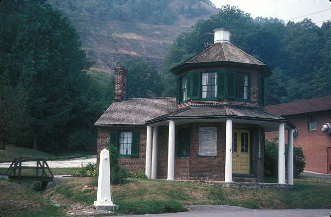


Why visit La Vale
Townapedia lists 29 museums and landmarks, 9 parks and trails, 32 places to eat, 4 places to stay and 2 attractions in and around town.
Highlights include Piney Mountain, La Vale Tollgate House, 16 Altamont Terrace and Constitution Park.
July is the warmest month, with average highs of 87°F; January lows average 22°F, and about 29 inches of snow fall in a normal year.
Weather in La Vale
Forecast from the National Weather Service. Full forecast
About La Vale
LaVale is a census-designated place (CDP) in Allegany County, Maryland, United States. It is part of the Cumberland, MD-WV Metropolitan Statistical Area. The population was 4,201 as of the 2020 census.
From the Wikipedia article LaVale, Maryland (this version), under CC BY-SA 4.0.
Things to do2

Museums and landmarks29
La Vale Tollgate House
Monument and historic site · National Register of Historic Places · 2.7 mi
Building in Allegany County, Maryland, United States

16 Altamont Terrace
Monument and historic site · National Register of Historic Places · 4.0 mi
Building in Cumberland, Maryland, United States

200-208 Decatur Street
Monument and historic site · National Register of Historic Places · 3.8 mi
Building in Cumberland, Maryland, United States

African Methodist Episcopal Church
Monument and historic site · National Register of Historic Places · 3.7 mi
Church in Cumberland Maryland

B'er Chayim Temple
Monument and historic site · National Register of Historic Places · 3.8 mi
Historic synagogue in Cumberland, Maryland, United States

Bell Tower Building
Monument and historic site · National Register of Historic Places · 3.6 mi
Building in Cumberland, Maryland, United States

Canada Hose Company Building
Monument and historic site · National Register of Historic Places · 3.3 mi
Fire station in Cumberland, United States of America

Chapel Hill Historic District
Monument and historic site · National Register of Historic Places · 4.2 mi
Historic district in Maryland, United States

City Hall
Monument and historic site · National Register of Historic Places · 3.6 mi
Seat of government in Cumberland, Maryland, United States

Cumberland YMCA
Monument and historic site · National Register of Historic Places · 3.8 mi
Building in Cumberland, Maryland, United States


Decatur Heights Historic District
Monument and historic site · National Register of Historic Places · 3.9 mi
Historic district in Maryland, United States

Downtown Cumberland Historic District
Monument and historic site · National Register of Historic Places · 3.8 mi
Historic district in downtown Cumberland, Maryland, United States
17 more on the map.
Parks, trails and playgrounds9


Restaurants and cafes32

Rio Grande Mexican Restaurant
Restaurant · Mexican · 2.4 mi
1217 National Highway, Cumberland
Mo-Sa 11:00-22:00; Su 11:00-21:00


Fratelli's Restaurant & Bar
Restaurant · Italian, Steak House · 1.3 mi
359 National Highway, LaVale
Mo-Sa 16:00-21:00

Simply Cakes by Ellie
Bakery · 1.9 mi
926 National Highway, LaVale
Tu-Su 08:00-14:00

The FroYo Factory
Ice cream · Frozen Yogurt · 2.4 mi
Delicious frozen yogurt shop located in a little plaza lot.
D'Atri's Resturant
Restaurant · 2.2 mi
Local restaurant that has baked goods along with a variety of foods from Italian dishes to other simpler meals.
20 more on the map.
Where to stay4
Churches and places of worship11
First Baptist Church
Church · National Register of Historic Places · 3.6 mi
Town Clock Church
Church · National Register of Historic Places · 3.6 mi
Christ Lutheran Church
Church · Lutheran · 2.7 mi
1222 Vocke Road Southwest, LaVale
Shopping6
Gas and EV charging7
Schools, colleges and libraries23
Center For Career & Technical Education
School · 4.9 mi
14211 Mcmullen Hwy Sw, Cresaptown
Healthcare5
Map of La Vale
128 places. The map loads OpenStreetMap tiles when you open it.
Climate by month
Monthly table
| Month | High | Low | Rain | Snow |
|---|---|---|---|---|
| Jan | 39°F | 22°F | 2.8 in | 8.2 in |
| Feb | 43°F | 24°F | 2.4 in | 7.7 in |
| Mar | 53°F | 31°F | 3.4 in | 6.8 in |
| Apr | 66°F | 41°F | 3.4 in | 0.1 in |
| May | 75°F | 51°F | 4.2 in | 0.0 in |
| Jun | 82°F | 60°F | 3.9 in | 0.0 in |
| Jul | 87°F | 64°F | 3.7 in | 0.0 in |
| Aug | 85°F | 63°F | 3.4 in | 0.0 in |
| Sep | 78°F | 55°F | 3.5 in | 0.0 in |
| Oct | 67°F | 43°F | 2.8 in | 0.0 in |
| Nov | 54°F | 34°F | 2.6 in | 0.5 in |
| Dec | 43°F | 27°F | 3.0 in | 5.4 in |
U.S. Climate Normals 1991-2020 for Cumberland 2 Hcn (4 mi away), NOAA NCEI.
People and cost of living
American Community Survey 5-year estimates, 2020-2024, U.S. Census Bureau. Estimates have margins of error, larger for small towns.
Disaster history
Allegany County has had 11 federal disaster declarations since 2000, most often for hurricanes.
- 2026-01-24: Severe Winter Storm (Winter Storm)
- 2020-03-26: Covid-19 Pandemic (Biological)
- 2020-03-13: Covid-19 (Biological)
- 2016-03-04: Severe Winter Storm And Snowstorm (Snowstorm)
- 2012-11-20: Hurricane Sandy (Hurricane)
- 2012-10-28: Hurricane Sandy (Hurricane)
OpenFEMA disaster declarations summaries.
Getting there and nearby towns
Greater Cumberland Regional Airport (CBE) is the nearest airport with scheduled flights listed in OpenStreetMap, 5 miles away.
- Cumberland 4 mi east, about 6 min by car
- Bowmans Addition 4 mi east, about 6 min by car
- Cresaptown 5 mi south, about 9 min by car
- Frostburg 6 mi west, about 9 min by car
- Bel Air 6 mi south, about 10 min by car
- Grantsville 17 mi west, about 28 min by car
- Hancock 35 mi east, about 57 min by car
- Johnstown 45 mi north, about 1 h 15 min by car
- Martinsburg 48 mi east, about 1 h 15 min by car
- Winchester 49 mi southeast, about 1 h 15 min by car
Drive times are estimates from straight-line distance, not routes.
Local news
Headlines from INDB, the NEMICO news database.
Reviews, tips and questions
Loading what members have shared...
Sources and licences
- NCES EDGE (Public domain): public schools
- NOAA NCEI U.S. Climate Normals 1991-2020 (Public domain): climate by month
- OpenFEMA (Public domain): disaster declarations
- OpenStreetMap contributors (ODbL 1.0): places, airports, map data
- U.S. Census Bureau (Public domain): population, income, housing, education, commute
- Wikidata (CC0 1.0): elevation, founding date, time zone, website, landmarks and historic places
- Wikimedia Commons (see each image): photos
- Wikipedia (CC BY-SA 4.0): overview and history text
Photo credits
- Four Mile House at La Vale, Nyttend, Public domain
- LA VALE TOLLGATE HOUSE, JERRYE & ROY KLOTZ MD, CC BY-SA 3.0
- Cumberland Public Safety Building MD1, Acroterion, CC BY-SA 4.0
- First Baptist Church Cumberland MD1, Acroterion, CC BY-SA 4.0
- AME Church Cumberland MD1, Acroterion, CC BY-SA 4.0
- Decatur Street Cumberland MD1, Acroterion, CC BY-SA 4.0
- Town Clock Church Cumberland MD1, Acroterion, CC BY-SA 4.0
- Cumberland City Hall MD1, Acroterion, CC BY-SA 4.0
- Wright Butler House Cumberland MD1, Acroterion, CC BY-SA 4.0
- Francis Haley House Mar 11, User:Pubdog, Public domain
- Thomas Koon House Mar 11, User:Pubdog, Public domain
- Greene St HD Cumberland MD1, Acroterion, CC BY-SA 4.0
- 200-208 Decatur St Cumberland MD1, Acroterion, CC BY-SA 4.0
- Rolling Mill Historic District Mar 11, Pubdog, Public domain
- Chapel Hill Historic District Mar 11, Pubdog, Public domain
- Cumberland MD Station WM Rwy 2003, Caseyjonz, Public domain
- George Truog House Mar 11, Pubdog, Public domain
- Klots Throwing Company Mill Mar 11, Pubdog, Public domain
- B&O Metropolitan and Shenandoah at Cumberland, December 5, 1970 (27638280026), Roger Puta, Public domain
- Bell Tower Bldg Cumberland MD1, Acroterion, CC BY-SA 4.0
- Cumberland YMCA MD1, Acroterion, CC BY-SA 4.0
- B'er Chayim Temple 02, Bohemian Baltimore, CC BY-SA 4.0
- 16 Altamont Terrace Mar 11, Pubdog, Public domain
- Penn Alps near Grantsville, Nyttend, Public domain
- MtSavageMD 2013 C&P Yard, Kevin M. Byrne, CC BY-SA 3.0
- Footer's Dye Works Building (25786544576), Preservation Maryland, CC BY-SA 2.0
- Washington Street Cumberland MD1, Acroterion, CC BY-SA 4.0
- Canada Hose Company Cumberland MD1, Acroterion, CC BY-SA 4.0
- Evergreen Heritage Center, people w- award (21412697578), Preservation Maryland, CC BY-SA 2.0
- Canal Place Field, Cumberland MD, Bonnachoven, CC0
- Cumberland MD Presby PHS683, Unknown author Unknown author, Public domain


Page built October 30, 2026. Spotted a mistake? Tell us or suggest a place.