


Ladera, California
Ladera is a community of 1,297 people in San Mateo County, California.
Why visit Ladera
Townapedia lists 10 museums and landmarks, 5 parks and trails, 10 places to eat, 2 places to stay and 3 attractions in and around town.
Highlights include Palo Alto University, Frost Amphitheater, Casa De Tableta and Folger Estate Stable Historic District.
August is the warmest month, with average highs of 89°F; December lows average 37°F.
Weather in Ladera
Forecast from the National Weather Service. Full forecast
About Ladera
Ladera is a census-designated place (CDP) in southern San Mateo County, California, United States, adjacent to Portola Valley. Primarily a residential community, it comprises approximately 520 homes, governed by the Ladera Community Association. The ZIP Code is 94028 and the community is inside area code 650. The population was 1,557 at the 2020 census.
From the Wikipedia article Ladera, California (this version), under CC BY-SA 4.0.
Things to do3

Palo Alto University
School · 1.4 mi
Private university located in Palo Alto, California, United States
1791 Arastradero Road, Palo Alto

Frost Amphitheater
Cinema and theater · 2.8 mi
Open-air theater at Stanford University in California

Stanford University
School · 2.5 mi
Private research university in Stanford, California, USA
Museums and landmarks10

Casa De Tableta
Monument and historic site · National Register of Historic Places · 1.3 mi
Historical building in San Mateo County, California, United States of America

Folger Estate Stable Historic District
Monument and historic site · National Register of Historic Places · 3.3 mi
Historical buildings and property in Woodside, California

Hanna–Honeycomb House
Monument and historic site · National Register of Historic Places · 2.2 mi
Historic house in California, United States

Kee House
Monument and historic site · National Register of Historic Places · 3.4 mi
Historic house in Palo Alto, California, United States
Lou Henry and Herbert Hoover House
Monument and historic site · National Register of Historic Places · 2.1 mi
Historic house in Stanford, California

MacFarland House
Monument and historic site · National Register of Historic Places · 2.0 mi
Historic house in California, United States

Palo Alto Stock Farm Horse Barn
Monument and historic site · National Register of Historic Places · 1.9 mi
Historic building in Stanford, California, USA

Portola Valley School
Monument and historic site · National Register of Historic Places · 2.0 mi

Cantor Arts Center at Stanford University
Museum · 2.8 mi
Art museum in Stanford, California
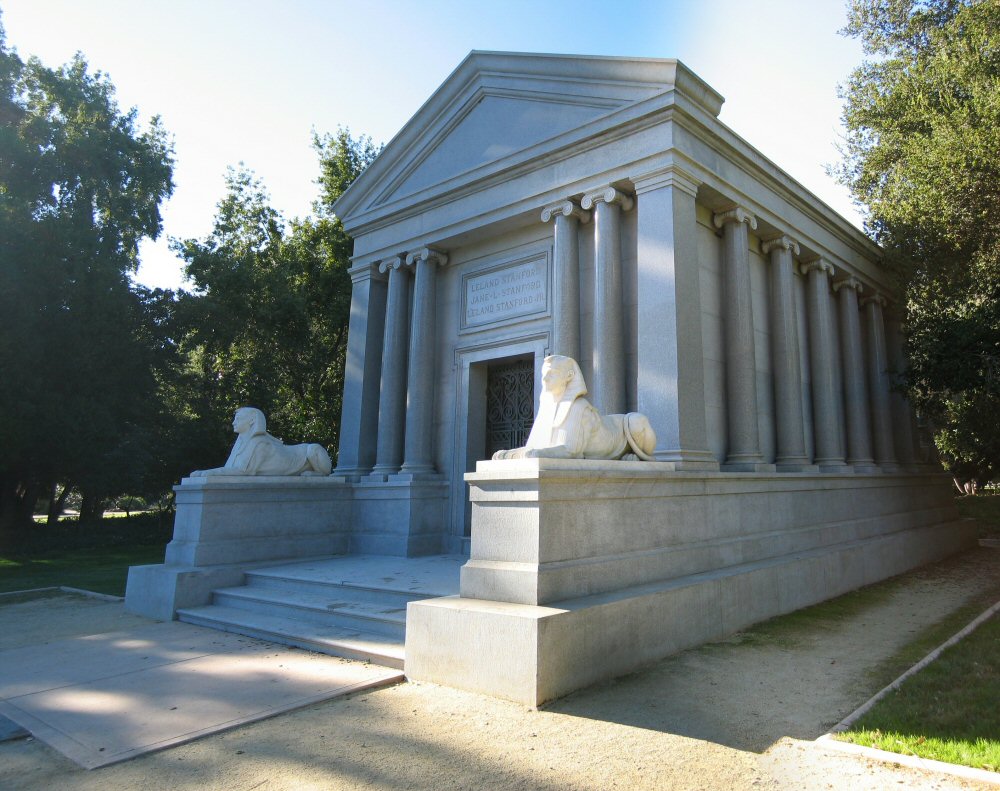
Stanford Mausoleum
Monument and historic site · 3.0 mi
Burial place in Palo Alto, California
Parks, trails and playgrounds5

Foothills Nature Preserve
Park · 3.4 mi
Nature preserve in Palo Alto, California, United States
Papua New Guinea Sculpture Garden
Park · 2.1 mi
Garden at Stanford University


Thornewood Open Space Preserve
Park · 3.4 mi
Park in the Santa Cruz Mountains of San Mateo County, California, United States

Restaurants and cafes10

Koma Sushi
Restaurant · Sushi
3130 Alpine Road, Portola Valley
Mo-Th 11:30-14:00, 16:30-20:00; Fr 11:30-14:00, 16:30-20:30; Sa 16:30-20:30
Rossotti's Alpine Inn
Restaurant · Burger, American · 1.3 mi
3915 Alpine Road, Portola Valley
Tu-Th 11:30-21:00; Fr 11:00-21:30; Sa 10:30-21:30; Su 10:30-21:00

Verve Coffee Roasters
Cafe · 1.4 mi
Not open to the public (on SLAC National Accelerator Laboratory site)
47 Loop Rd
Mo-Fr 07:00-14:00
Konditorei Cafe
Cafe · Ice Cream, Coffee Shop
3130 Alpine Road, Portola Valley
Mo-Fr 06:30-14:30; Sa 07:00-14:30; Su 07:00-13:30
History
The Ramaytush Ohlone peoples occupied the land that is now the community of Ladera, prior to the settlement of California by the Spanish. Ladera is located on the Rancho Corte de Madera Mexican land grant.
The land was used for grazing and timber through 1927 when it was joined to the Ormondale Ranch, owned by the Macdonough family. The Macdonoughs raised cattle and sheep, and bred racehorses; their most famous stud, Ormonde, had raced in England and never lost a race. In the 1930s, the majority of the Ormondale Ranch land was developed and incorporated into Portola Valley.
In 1944, the Peninsula Housing Association (PHA) was formed with the goal of purchasing a tract of land and developing a housing cooperative. Several prominent members of the Stanford and Palo Alto communities joined to develop the fledgling PHA co-op. It began subscribing members in 1945 and its 150 members purchased the remaining 260 acres (1.1 km2) of the former Ormondale ranch for $155,000 on July 31, 1946. The co-op selected noted landscape architect Garrett Eckbo to lay out the design for the new community. Architects Joseph Allen Stein and John Funk were chosen to design several of the earliest model homes.
From the History section of Ladera, California on Wikipedia, under CC BY-SA 4.0.
Where to stay2
Churches and places of worship3
Our Lady of the Wayside Church
Church · National Register of Historic Places · 2.2 mi
Shopping1
Gas and EV charging2
Schools, colleges and libraries41
Map of Ladera
77 places. The map loads OpenStreetMap tiles when you open it.
Climate by month
Monthly table
| Month | High | Low | Rain |
|---|---|---|---|
| Jan | 61°F | 38°F | 7.4 in |
| Feb | 64°F | 40°F | 7.4 in |
| Mar | 69°F | 41°F | 7.7 in |
| Apr | 73°F | 43°F | 3.6 in |
| May | 78°F | 47°F | 1.6 in |
| Jun | 84°F | 50°F | 0.7 in |
| Jul | 88°F | 53°F | 0.0 in |
| Aug | 89°F | 52°F | 0.1 in |
| Sep | 87°F | 51°F | 0.1 in |
| Oct | 80°F | 46°F | 2.1 in |
| Nov | 68°F | 41°F | 4.5 in |
| Dec | 61°F | 37°F | 8.5 in |
U.S. Climate Normals 1991-2020 for Woodside Fire Stn 1 (4 mi away), rain and snow from Woodside 3.4 S, NOAA NCEI.
People and cost of living
American Community Survey 5-year estimates, 2020-2024, U.S. Census Bureau. Estimates have margins of error, larger for small towns.
Disaster history
San Mateo County has had 14 federal disaster declarations since 2000, most often for floods.
- 2023-04-03: Severe Winter Storms, Straight-Line Winds, Flooding, Landslides, And Mudslides (Severe Storm)
- 2023-03-10: Severe Winter Storms, Flooding, Landslides, And Mudslides (Flood)
- 2023-01-14: Severe Winter Storms, Flooding, Landslides, And Mudslides (Flood)
- 2023-01-09: Severe Winter Storms, Flooding, And Mudslides (Flood)
- 2020-08-22: Wildfires (Fire)
- 2020-08-20: Czu Lightning Fire Complex (Fire)
OpenFEMA disaster declarations summaries.
Getting there and nearby towns
Palo Alto Airport (PAO) is the nearest airport with scheduled flights listed in OpenStreetMap, 6 miles away.
- Stanford 3 mi northeast, about 4 min by car
- Palo Alto 3 mi east, about 5 min by car
- North Fair Oaks 5 mi north, about 8 min by car
- East Palo Alto 6 mi northeast, about 10 min by car
- Los Altos 6 mi east, about 10 min by car
- Menlo Park 6 mi northeast, about 10 min by car
- Mountain View 7 mi east, about 11 min by car
- Redwood City 8 mi north, about 13 min by car
- San Carlos 8 mi northwest, about 13 min by car
- Sunnyvale 10 mi east, about 15 min by car
Drive times are estimates from straight-line distance, not routes.
Local news
Headlines from INDB, the NEMICO news database.
Reviews, tips and questions
Loading what members have shared...
Sources and licences
- NCES EDGE (Public domain): public schools
- NOAA NCEI U.S. Climate Normals 1991-2020 (Public domain): climate by month
- OpenFEMA (Public domain): disaster declarations
- OpenStreetMap contributors (ODbL 1.0): places, airports, map data
- U.S. Census Bureau (Public domain): population, income, housing, education, commute
- Wikidata (CC0 1.0): elevation, founding date, time zone, website, landmarks and historic places
- Wikimedia Commons (see each image): photos
- Wikipedia (CC BY-SA 4.0): overview and history text
Photo credits
- Casa de Tableta, Portola Valley, California, W Nowicki, CC BY 3.0
- Kee House, 2310 Yale St., Palo Alto, CA 6-3-2012 3-48-19 PM, Sanfranman59, CC BY-SA 3.0
- Folger Estate Stable Historic District, 4040 Woodside Rd., Woodside, CA 9-18-2011 4-24-36 PM, Sanfranman59, CC BY-SA 3.0
- Lou Henry Hoover House from E, Jack Boucher, Public domain
- Electioneer statue and Palo Alto Stock Farm horse barn, Fremont Rd., Palo Alto, CA 6-3-2012 3-06-34 PM, Sanfranman59, CC BY-SA 3.0
- MacFarland House, 775 Santa Ynez St., Stanford, CA 6-3-2012 3-23-08 PM, Sanfranman59, CC BY-SA 3.0
- Portola Valley School, W Nowicki, CC BY 3.0
- Bob Weir & The Wolf Pack Mickey Hart's Planet Drum (52070816800), Bob Aronson from Monterey, CA, US, CC BY-SA 2.0
- Thornewood Open Space Preserve mountains and trail, Runner1928, CC BY-SA 3.0
- Stanford Mausoleum, Jawed Karim, CC BY-SA 3.0
- Stanford Oval May 2011 panorama, King of Hearts, CC BY-SA 3.0
- Stanford Memorial Church (2025)-L1007381, Frank Schulenburg, CC BY-SA 4.0
- ISS034-E-41039 - View of Earth, Earth Science and Remote Sensing Unit , Lyndon B. Johnson Space Center, Public domain
- ISS055-E-90918 - View of Earth, Earth Science and Remote Sensing Unit, NASA Johnson Space Center, Public domain
- ISS055-E-90916 - View of Earth, Earth Science and Remote Sensing Unit, NASA Johnson Space Center, Public domain
- ISS009-E-28494 - View of California, Earth Science and Remote Sensing Unit , Lyndon B. Johnson Space Center, Public domain
- ISS055-E-90917 - View of Earth, Earth Science and Remote Sensing Unit, NASA Johnson Space Center, Public domain
- ISS042-E-122569 - View of Earth, Earth Science and Remote Sensing Unit , Lyndon B. Johnson Space Center, Public domain
- ISS055-E-27321 - View of Earth, Earth Science and Remote Sensing Unit, NASA Johnson Space Center, Public domain
- ISS055-E-90915 - View of Earth, Earth Science and Remote Sensing Unit, NASA Johnson Space Center, Public domain
- ISS042-E-122568 - View of Earth, Earth Science and Remote Sensing Unit , Lyndon B. Johnson Space Center, Public domain
- Pisolithus tinctorius (San Mateo, California, USA) 2, Bob Dodgel, CC BY 4.0
- Pisolithus tinctorius (San Mateo, California, USA) 4, Bob Dodgel, CC BY 4.0
- Pisolithus tinctorius (San Mateo, California, USA) 3, Bob Dodgel, CC BY 4.0
- Pisolithus tinctorius (San Mateo, California, USA) 1, Bob Dodgel, CC BY 4.0
- Trowbridge's Shrew (Sorex trowbridgii) observed by bob-dodge, Trowbridge's Shrew (Sorex trowbridgii) (Sorex trowbridgii) observed by bob-dodge https://creativecommons.org/licenses/by/3.0/, CC BY 4.0
- Olallieberry (cropped), Liji Jinaraj, CC BY-SA 2.0
- Olallieberry, Liji Jinaraj, CC BY-SA 2.0
- Andricus opertus - iNaturalist 159131316, Garth Harwood, CC BY 4.0
- Pear Gall Wasp imported from iNaturalist photo 159130963 on 26 October 2023, (c) Garth Harwood, some rights reserved (CC BY), CC BY 4.0
- Disholcaspis washingtonensis gall, iNaturalist user: bob-dodge, CC BY 4.0
- Bus is Burning (48008754778), jurvetson, CC BY 2.0
- M551 Sheridan Tank (519491303), Craig Howell from San Carlos, CA, USA, CC BY 2.0
- Fireman and Burning Bus (48008747896), jurvetson, CC BY 2.0
- Apple Commuter Bus is Burning (48008834722), jurvetson, CC BY 2.0
- Felt Lake, Yifei He, CC BY-SA 4.0
- Feron gigas - iNaturalist 313270378, Cricket Raspet, CC BY 4.0
- Mallard mailbox, Suiren2022, CC BY-SA 4.0
- Webb Ranch Pumpkin Patch, Suiren2022, CC BY-SA 4.0
- Callirhytis eldoradensis imported from iNaturalist photo 317490434 on 24 October 2023, (c) Cricket Raspet, some rights reserved (CC BY), CC BY 4.0


Page built October 30, 2026. Spotted a mistake? Tell us or suggest a place.