


Lampeter, Pennsylvania
Lampeter is a community of 2,140 people in Lancaster County, Pennsylvania.
Why visit Lampeter
Townapedia lists 10 museums and landmarks, 3 parks and trails and 6 attractions in and around town.
Highlights include Lime Valley Covered Bridge, Daniel Good's Fording Covered Bridge, Hans Herr House and Johannes Harnish Farmstead.
July is the warmest month, with average highs of 87°F; January lows average 22°F, and about 21 inches of snow fall in a normal year.
Weather in Lampeter
Forecast from the National Weather Service. Full forecast
About Lampeter
Lampeter is an unincorporated community and census-designated place (CDP) in West Lampeter Township, Pennsylvania, United States. As of the 2010 census, it had a population of 1,669. It is a suburb of Lancaster and has a ZIP code of 17537. The community was named after Lampeter, in Wales.
From the Wikipedia article Lampeter, Pennsylvania (this version), under CC BY-SA 4.0.
Things to do6

Lime Valley Covered Bridge
Bridge · National Register of Historic Places · 2.3 mi
Covered bridge

Daniel Good's Fording Covered Bridge
Bridge · 3.1 mi
Bridge in Lancaster, Pennsylvania

Dutch Wonderland
Monument and historic site · 2.8 mi
Amusement park in Lancaster, Pennsylvania, United States

Kurtz's Mill Covered Bridge
Bridge · 2.4 mi
Covered bridge in Pennsylvania, United States

Sight & Sound Millennium Theatre
Cinema and theater · 3.1 mi
Christian theater in Ronks, Lancaster County, Pennsylvania, United States

Willow Hill Covered Bridge
Bridge · 3.1 mi
Covered bridge located off U.S. Route 30 that spans Miller’s Run in Lancaster County, Pennsylvania
Museums and landmarks10
Hans Herr House
Monument and historic site · National Register of Historic Places · 1.3 mi
Historic house in Pennsylvania, United States

Johannes Harnish Farmstead
Monument and historic site · National Register of Historic Places · 2.2 mi
Building in Pennsylvania, United States
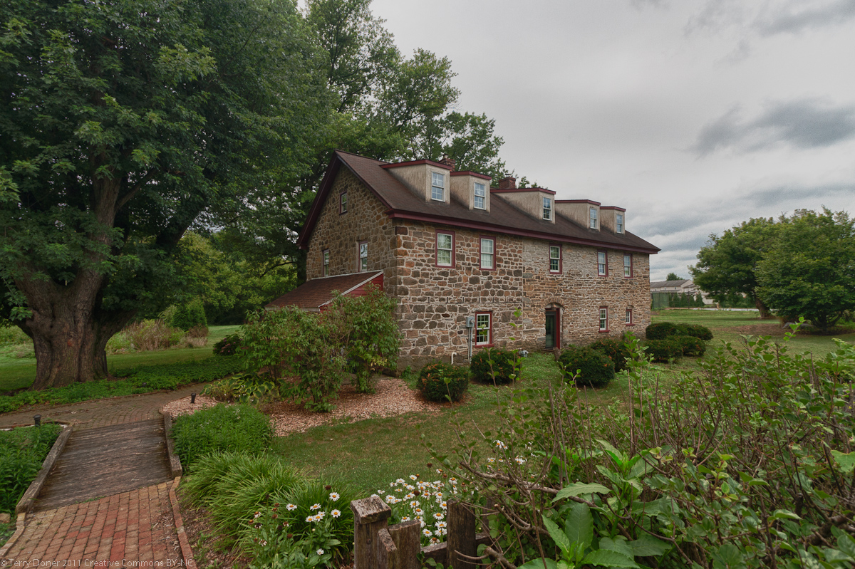
Michael Dohner Farmhouse
Monument and historic site · National Register of Historic Places · 2.5 mi
Historic house in Pennsylvania, United States

Neff's Mill Covered Bridge
Bridge · National Register of Historic Places · 1.5 mi
Pequea #7 Bridge

Park Site (36LA96)
Monument and historic site · National Register of Historic Places · 2.7 mi
Archaeological site in West Lampeter Township, United States of America

Rock Ford Plantation
Monument and historic site · National Register of Historic Places · 2.9 mi
Building in Pennsylvania, United States

Strasburg Historic District
Monument and historic site · National Register of Historic Places · 3.2 mi
Historic district in Pennsylvania, United States

Weber-Weaver Farm
Monument and historic site · National Register of Historic Places · 1.0 mi
Building in Pennsylvania, United States



Witmer's Tavern
Monument and historic site · National Register of Historic Places · 3.2 mi
Parks, trails and playgrounds3

Churches and places of worship2

Lampeter Church of the Brethren
Church · Anabaptist · 0.9 mi
1900 Lampeter Road, Lancaster
Lampeter United Methodist Church
Church · United Methodist · 0.9 mi
1101 Village Road, Lancaster
Gas and EV charging1
Schools, colleges and libraries41
Map of Lampeter
63 places. The map loads OpenStreetMap tiles when you open it.
Climate by month
Monthly table
| Month | High | Low | Rain | Snow |
|---|---|---|---|---|
| Jan | 40°F | 22°F | 3.0 in | 6.1 in |
| Feb | 43°F | 24°F | 2.5 in | 7.4 in |
| Mar | 52°F | 31°F | 3.5 in | 3.4 in |
| Apr | 65°F | 40°F | 3.5 in | 0.2 in |
| May | 74°F | 50°F | 3.6 in | 0.0 in |
| Jun | 83°F | 60°F | 4.1 in | 0.0 in |
| Jul | 87°F | 65°F | 4.5 in | 0.0 in |
| Aug | 85°F | 63°F | 3.6 in | 0.0 in |
| Sep | 78°F | 56°F | 4.8 in | 0.0 in |
| Oct | 66°F | 44°F | 4.2 in | 0.3 in |
| Nov | 55°F | 34°F | 3.3 in | 0.6 in |
| Dec | 44°F | 27°F | 3.5 in | 3.4 in |
U.S. Climate Normals 1991-2020 for Lancaster 2Ne Fltr Plt (4 mi away), NOAA NCEI.
People and cost of living
American Community Survey 5-year estimates, 2020-2024, U.S. Census Bureau. Estimates have margins of error, larger for small towns.
Disaster history
Lancaster County has had 13 federal disaster declarations since 2000, most often for hurricanes.
- 2020-03-30: Covid-19 Pandemic (Biological)
- 2020-03-13: Covid-19 (Biological)
- 2016-03-23: Severe Winter Storm And Snowstorm (Snowstorm)
- 2014-02-06: Severe Winter Storm (Severe Ice Storm)
- 2012-10-29: Hurricane Sandy (Hurricane)
- 2011-09-12: Tropical Storm Lee (Flood)
OpenFEMA disaster declarations summaries.
Getting there and nearby towns
Lancaster Airport (LNS) is the nearest airport with scheduled flights listed in OpenStreetMap, 9 miles away.
- Lancaster 4 mi northwest, about 7 min by car
- Conestoga 6 mi southwest, about 10 min by car
- Paradise 7 mi east, about 11 min by car
- Intercourse 8 mi east, about 13 min by car
- East Petersburg 9 mi northwest, about 15 min by car
- Brownstown 9 mi north, about 15 min by car
- Landisville 11 mi northwest, about 17 min by car
- Akron 12 mi north, about 19 min by car
- Gap 12 mi east, about 19 min by car
- Ephrata 13 mi north, about 22 min by car
Drive times are estimates from straight-line distance, not routes.
Local news
Headlines from INDB, the NEMICO news database.
Reviews, tips and questions
Loading what members have shared...
Sources and licences
- NCES EDGE (Public domain): public schools
- NOAA NCEI U.S. Climate Normals 1991-2020 (Public domain): climate by month
- OpenFEMA (Public domain): disaster declarations
- OpenStreetMap contributors (ODbL 1.0): places, airports, map data
- U.S. Census Bureau (Public domain): population, income, housing, education, commute
- Wikidata (CC0 1.0): elevation, founding date, time zone, website, landmarks and historic places
- Wikimedia Commons (see each image): photos
- Wikipedia (CC BY-SA 4.0): overview and history text
Photo credits
- Lampeter, Pennsylvania (6291403132), Doug Kerr from Albany, NY, United States, CC BY-SA 2.0
- West Lampeter Township, PA municipal building, Feb. 2026, Mr. Matté (if there is an issue with this image, contact me using this image's Commons talk page , my Commons user talk page , or my English Wikipedia user talk page ; I'll know about it a lot faster), CC BY-SA 4.0
- Lampeter Cafe, Lampeter, PA, Feb. 2026, Mr. Matté (if there is an issue with this image, contact me using this image's Commons talk page , my Commons user talk page , or my English Wikipedia user talk page ; I'll know about it a lot faster), CC BY-SA 4.0
- PA 741 wb in Lampeter, Feb. 2026, Mr. Matté (if there is an issue with this image, contact me using this image's Commons talk page , my Commons user talk page , or my English Wikipedia user talk page ; I'll know about it a lot faster), CC BY-SA 4.0
- Lampeter, Pennsylvania (6291402648), Doug Kerr from Albany, NY, United States, CC BY-SA 2.0
- Lampeter, Pennsylvania (6291402804), Doug Kerr from Albany, NY, United States, CC BY-SA 2.0
- Lampeter, Pennsylvania (6290883877), Doug Kerr from Albany, NY, United States, CC BY-SA 2.0
- Lampeter, Pennsylvania (6291402932), Doug Kerr from Albany, NY, United States, CC BY-SA 2.0
- Harvest Presbyterian Church, West Lampeter Township, PA, Feb. 2026, Mr. Matté (if there is an issue with this image, contact me using this image's Commons talk page , my Commons user talk page , or my English Wikipedia user talk page ; I'll know about it a lot faster), CC BY-SA 4.0
- Lampeter-Strasburg High School, Feb. 2026, Mr. Matté (if there is an issue with this image, contact me using this image's Commons talk page , my Commons user talk page , or my English Wikipedia user talk page ; I'll know about it a lot faster), CC BY-SA 4.0
- Lampeter, PA United Methodist Church, Feb. 2026, Mr. Matté (if there is an issue with this image, contact me using this image's Commons talk page , my Commons user talk page , or my English Wikipedia user talk page ; I'll know about it a lot faster), CC BY-SA 4.0
- PA 741 wb entering Lampeter, Feb. 2026, Mr. Matté (if there is an issue with this image, contact me using this image's Commons talk page , my Commons user talk page , or my English Wikipedia user talk page ; I'll know about it a lot faster), CC BY-SA 4.0
- West Lampeter Township, PA, USA - panoramio, Idawriter, CC BY-SA 3.0
- West Lampeter Township, PA, USA - panoramio (1), Idawriter, CC BY-SA 3.0
- Neff's Mill Covered Bridge Side View 3000px, Photo by and (c)2006 Derek Ramsey ( Ram-Man ), CC BY-SA 2.5
- Lime Valley Covered Bridge Side View 3000px, Photo by and (c)2006 Derek Ramsey ( Ram-Man ), CC BY-SA 2.5
- PARK SITE - 36LA96 - WEST LAMPETER TWP, LANCASTER COUNTY, Jerrye & Roy Klotz, MD, CC BY-SA 4.0
- WEBER-WEAVER FARM, WEST LAMPETER, LANCASTER COUNTY, PA, Jerrye & Roy Klotz, MD, CC BY-SA 4.0
- Rock Ford Plantation Lancaster Front 1456px, Photo by and (c)2008 Colin Hines www.ColinHinesPhotography.com, GFDL 1.2
- Michael Dohner Farmhouse, Terry Doner, CC BY-SA 3.0
- Strasburg Odd Fellows, Smallbones, Public domain
- JOHANNES HARNISH FARMSTEAD, LANCASTER COUNTY, PA, Jerrye & Roy Klotz, MD, CC BY-SA 4.0
- Witmers Tavern front LanCo PA, Smallbones, CC BY-SA 3.0
- Willow Hill Covered Bridge Side View 3000px, Photo by and (c)2006 Derek Ramsey ( Ram-Man ), CC BY-SA 2.5
- Kurtz's Mill Covered Bridge Side View 3008px, Photo by and (c)2006 Derek Ramsey ( Ram-Man ), CC BY-SA 2.5
- PA 741 wb approaching US 222 sb, Feb. 2026, Mr. Matté (if there is an issue with this image, contact me using this image's Commons talk page , my Commons user talk page , or my English Wikipedia user talk page ; I'll know about it a lot faster), CC BY-SA 4.0
- US 222 NB past Penn Grant Road, Dough4872, CC BY-SA 4.0
- Willow Street, PA, USA - panoramio, Idawriter, CC BY-SA 3.0
- Herr House 06 2026, Concord, CC BY-SA 4.0
- Covered Bridge over Pequea Creek - panoramio, Idawriter, CC BY-SA 3.0
- Inside the Covered Bridge - panoramio, Idawriter, CC BY-SA 3.0
- Willow Street Mennonite Church Cemetery 06 2026 03, Concord, CC BY-SA 4.0


Page built October 30, 2026. Spotted a mistake? Tell us or suggest a place.