


Little Flock, Arkansas
Little Flock is a city of 3,056 people in Benton County, Arkansas.
Why visit Little Flock
Townapedia lists 53 museums and landmarks, 7 parks and trails, 7 places to eat and 2 places to stay in and around town.
Highlights include Old High Middle School and Applegate Drugstore.
August is the warmest month, with average highs of 90°F; January lows average 24°F.
Weather in Little Flock
Forecast from the National Weather Service. Full forecast
About Little Flock
Little Flock is a city in Benton County, Arkansas, United States. The population was 3,055 at the 2020 census. It is part of the Northwest Arkansas region.
From the Wikipedia article Little Flock, Arkansas (this version), under CC BY-SA 4.0.
Museums and landmarks53

Old High Middle School
Monument and historic site · National Register of Historic Places · 4.3 mi
School building in Bentonville, United States of America
406 Nw Second St, Bentonville

Applegate Drugstore
Monument and historic site · National Register of Historic Places · 3.7 mi
United States historic place

Bank of Rogers Building
Monument and historic site · National Register of Historic Places · 3.7 mi
Historic commercial building in Rogers, Arkansas, United States

Benton County Courthouse
Monument and historic site · National Register of Historic Places · 4.0 mi
Courthouse in Bentonville, Benton County, Arkansas

Benton County Jail
Monument and historic site · National Register of Historic Places · 4.0 mi
Jail in Bentonville, Arkansas

Benton County National Bank
Monument and historic site · National Register of Historic Places · 4.1 mi
Bank building in Bentonville, Arkansas

Benton County Poor Farm Cemetery
Monument and historic site · National Register of Historic Places · 3.6 mi
Historic cemetery in Arkansas, United States
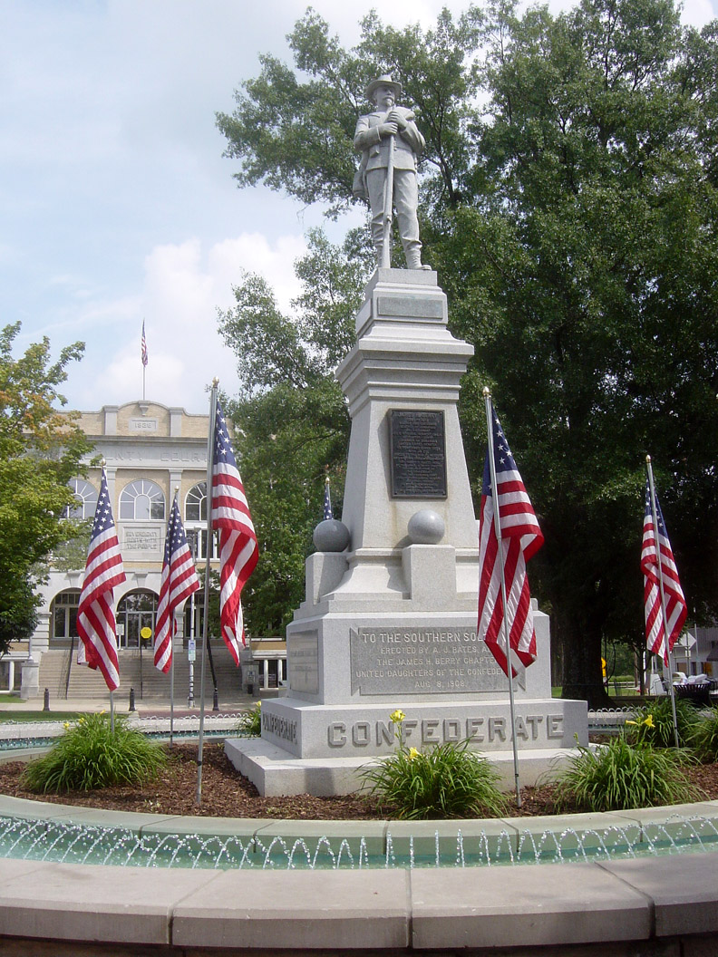
Bentonville Confederate Monument
Monument and historic site · National Register of Historic Places · 4.0 mi
Monument in Bentonville, United States of America

Bentonville Third Street Historic District
Monument and historic site · National Register of Historic Places · 4.0 mi
Historic district in Bentonville, Arkansas

Bentonville Train Station
Monument and historic site · National Register of Historic Places · 4.2 mi
Railway station in Bentonville, the United States of America

Bentonville West Central Avenue Historic District
Monument and historic site · National Register of Historic Places · 4.4 mi
Historic district in Bentonville, Arkansas


Bertschy House
Monument and historic site · National Register of Historic Places · 4.4 mi
Historic house in Arkansas, United States
41 more on the map.
Parks, trails and playgrounds7



Restaurants and cafes7




Domino's
Fast food · Pizza · 2.0 mi
2100 West Hudson Road, Rogers
Mo-Th 10:00-24:00; Fr-Sa 10:00-01:00; Su 10:00-24:00
Where to stay2

Churches and places of worship7
Shopping1
Gas and EV charging4
Schools, colleges and libraries42
Founders Classical Academies of Arkansas Bentonville
School · 5.3 mi
1300 Melissa Dr Ste 216, Bentonville
Founders Classical Academies of Arkansas High School Rogers
School · 5.3 mi
1300 Melissa Dr Ste 216, Bentonville
Founders Classical Academies of Arkansas Rogers
School · 5.3 mi
800 S. Dodson Rd., Rogers
Founders Classical Academy Elementary Online
School · 5.3 mi
1302 Melissa Dr, Bentonville
Map of Little Flock
123 places. The map loads OpenStreetMap tiles when you open it.
Climate by month
Monthly table
| Month | High | Low | Rain | Snow |
|---|---|---|---|---|
| Jan | 46°F | 24°F | 2.7 in | 3.2 in |
| Feb | 51°F | 27°F | 2.7 in | 2.3 in |
| Mar | 60°F | 36°F | 4.2 in | 2.6 in |
| Apr | 69°F | 44°F | 4.8 in | 0.0 in |
| May | 77°F | 54°F | 6.3 in | 0.0 in |
| Jun | 85°F | 63°F | 5.5 in | 0.0 in |
| Jul | 89°F | 66°F | 3.9 in | 0.0 in |
| Aug | 90°F | 65°F | 2.7 in | 0.0 in |
| Sep | 82°F | 57°F | 4.0 in | 0.0 in |
| Oct | 71°F | 46°F | 3.4 in | 0.0 in |
| Nov | 59°F | 36°F | 3.9 in | 0.2 in |
| Dec | 49°F | 27°F | 3.3 in | 1.2 in |
U.S. Climate Normals 1991-2020 for Bentonville 4 S (6 mi away), NOAA NCEI.
People and cost of living
American Community Survey 5-year estimates, 2020-2024, U.S. Census Bureau. Estimates have margins of error, larger for small towns.
Disaster history
Benton County has had 19 federal disaster declarations since 2000, most often for severe storms.
- 2026-01-24: Severe Winter Storm (Winter Storm)
- 2025-04-05: Severe Storms, Tornadoes, And Flooding (Severe Storm)
- 2024-05-30: Severe Storms, Straight-Line Winds, Tornadoes, And Flooding (Severe Storm)
- 2020-08-27: Hurricane Laura (Hurricane)
- 2020-04-03: Covid-19 Pandemic (Biological)
- 2020-03-13: Covid-19 (Biological)
OpenFEMA disaster declarations summaries.
Getting there and nearby towns
Rogers Executive Airport (ROG) is the nearest airport with scheduled flights listed in OpenStreetMap, 2 miles away.
- Rogers 5 mi south, about 7 min by car
- Bentonville 6 mi west, about 9 min by car
- Bella Vista 9 mi northwest, about 15 min by car
- Centerton 9 mi west, about 15 min by car
- Lowell 9 mi south, about 14 min by car
- Springdale 13 mi south, about 21 min by car
- Gravette 13 mi west, about 21 min by car
- Highfill 13 mi southwest, about 21 min by car
- Elm Springs 13 mi southwest, about 22 min by car
- Johnson 17 mi south, about 28 min by car
Drive times are estimates from straight-line distance, not routes.
Local news
Headlines from INDB, the NEMICO news database.
Reviews, tips and questions
Loading what members have shared...
Sources and licences
- NCES EDGE (Public domain): public schools
- NOAA NCEI U.S. Climate Normals 1991-2020 (Public domain): climate by month
- OpenFEMA (Public domain): disaster declarations
- OpenStreetMap contributors (ODbL 1.0): places, airports, map data
- U.S. Census Bureau (Public domain): population, income, housing, education, commute
- Wikidata (CC0 1.0): elevation, founding date, time zone, website, landmarks and historic places
- Wikimedia Commons (see each image): photos
- Wikipedia (CC BY-SA 4.0): overview and history text
Photo credits
- Bentonville High, Milesdap, CC BY-SA 3.0
- Vinson House, Valis55, CC BY-SA 3.0
- Kefauver House, Valis55, CC BY-SA 3.0
- Hotel Massey, Brandonrush, CC BY-SA 3.0
- Braithwaite House, Valis55, CC BY-SA 3.0
- Bertschy House, Valis55, CC BY-SA 3.0
- Applegate Drugstore, Valis55, CC BY-SA 3.0
- Craig-Bryan House, Brandonrush, CC BY-SA 3.0
- Bentonville Third Street Historic District, 1 of 4, Valis55, CC BY-SA 3.0
- BREEDLOVE HOUSE AND WATER TOWER, BENTON COUNTY, AR, JERRYE & ROY KLOTZ MD, CC BY-SA 4.0
- Craig-Bryan House, Bentonville, Alfredo Carrillo, CC BY 2.0
- Linebarger House, Bentonville, AR, Brandonrush, CC BY-SA 3.0
- Benton County Jail, Bentonville, AR, Brandonrush, CC BY-SA 3.0
- Merrill House, Valis55, CC BY-SA 3.0
- Campbell House, Rogers, AR, Valis55, CC BY-SA 3.0
- Mutual Aid Union Building, Valis55, CC BY-SA 3.0
- Benton County Poor Farm Cemetery, Valis55, CC BY-SA 3.0
- Terry Block Building, Brandonrush, CC BY-SA 3.0
- Lane Hotel, Valis55, CC BY-SA 3.0
- Freeman-Felker House, Valis55, CC BY-SA 3.0
- Charles R. Craig Building, Brandonrush, CC BY-SA 3.0
- Smith House, Bentonville, AR, Valis55, CC BY-SA 3.0
- Koons House, Valis55, CC BY-SA 3.0
- Bryan House No. 2, Rogers, AR, Valis55, CC BY-SA 3.0
- Parks-Reagan House, Valis55, CC BY-SA 3.0
- Jackson House, Bentonville, AR, Brandonrush, CC BY-SA 3.0
- James Rice House, Valis55, CC BY-SA 3.0
- Col. Young House, Valis55, CC BY-SA 3.0
- Rogers Post Office Building, Valis55, CC BY-SA 3.0
- Putman Cemetery, Valis55, CC BY-SA 3.0
- Bank of Rogers Building, Valis55, CC BY-SA 3.0
- Benton County National Bank, Brandonrush, CC BY-SA 3.0
- Morris House, Bentonville, AR, Valis55, CC BY-SA 3.0
- Stroud House, Bentonville, Benton County, AR, JERRYE & ROY KLOTZ MD, CC BY-SA 4.0
- Benton County Courthouse, Bentonville, Arkansas, Brandonrush, CC BY-SA 3.0
- Charles Juhre House, Valis55, CC BY-SA 3.0
- Macon-Harrison House, Valis55, CC BY-SA 3.0
- MillerHomesteadShedPeaRidgeAR, Melodibit, CC BY-SA 3.0
- 09-02-06-BentonvilleConfed-monument, Bobak Ha'Eri, CC BY 2.5
- Blackburn House, Rogers, AR, Valis55, CC BY-SA 3.0


Page built October 30, 2026. Spotted a mistake? Tell us or suggest a place.