
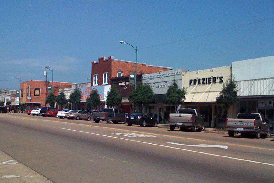


Louisville, Mississippi
Louisville is a city of 5,983 people in Winston County, Mississippi.
Why visit Louisville
Townapedia lists 4 museums and landmarks, 8 places to eat, 3 places to stay and 2 attractions in and around town.
Highlights include Northgate Cinema, Benjamin Franklin Smyth House and Foster-Fair House.
July is the warmest month, with average highs of 92°F; January lows average 34°F.
Weather in Louisville
Forecast from the National Weather Service. Full forecast
About Louisville
Louisville (pronounced LEW-iss-vill) is a city in and the county seat of Winston County, Mississippi. The population was 6,072 at the 2020 census.
From the Wikipedia article Louisville, Mississippi (this version), under CC BY-SA 4.0.
Things to do2

Museums and landmarks4

Benjamin Franklin Smyth House
Monument and historic site · National Register of Historic Places · 2.0 mi
Historic house in Louisville, Mississippi

Foster-Fair House
Monument and historic site · National Register of Historic Places · 0.4 mi
Historic two-story house in Louisville, Mississippi

Legion State Park
Monument and historic site · National Register of Historic Places · 2.1 mi
Located in the red hill country of Louisville, Mississippi, and area originally inhabited by the Choctaw Indian Nation


Old Masonic Hall
Monument and historic site · National Register of Historic Places
Masonic temple in Louisville, Mississippi
Restaurants and cafes8



McDonald's
Fast food · Burger · 1.7 mi
962 West Main Street
Mo-Th 00:00-24:00; Fr 04:00-24:00; Sa 05:00-24:00; Su 05:00-04:00
Sonic
Fast food · Burger
2317 South Church Avenue, Louisville
Mo-Th 06:30-22:00; Fr 06:30-23:00; Sa 07:00-23:00; Su 08:00-22:00
Where to stay3

History
Like Winston County, Louisville is named for Louis Winston (1784–1824), a colonel in the militia, a prominent lawyer, and a judge of the Mississippi Supreme Court. In 1863 Union Colonel Benjamin Grierson marched 900 troops through Louisville during his raid through Mississippi. There was no fighting in Winston County.
In 1927, a mob of 1,000 white men from Louisville, lynched two African-Americans, Jim and Mark Fox by wrapping them in barbed wire and setting them on fire. The Foxes were accused of killing Clarence Nichols, a white man who started a fight with them because they would not let him pass their Ford touring car in his Chevrolet.
On April 28, 2014, Louisville was hit by an EF4 tornado, resulting in ten fatalities.
From the History section of Louisville, Mississippi on Wikipedia, under CC BY-SA 4.0.
Churches and places of worship17
Sacred Heart Catholic Church
Church · Roman Catholic · 0.4 mi
630 North Spring Avenue, Louisville
Shopping8
Gas and EV charging9
Schools, colleges and libraries7
Healthcare4
Map of Louisville
62 places. The map loads OpenStreetMap tiles when you open it.
Climate by month
Monthly table
| Month | High | Low | Rain |
|---|---|---|---|
| Jan | 55°F | 34°F | 5.0 in |
| Feb | 59°F | 37°F | 5.7 in |
| Mar | 68°F | 44°F | 5.5 in |
| Apr | 75°F | 51°F | 5.3 in |
| May | 82°F | 60°F | 5.0 in |
| Jun | 89°F | 67°F | 4.0 in |
| Jul | 92°F | 71°F | 4.6 in |
| Aug | 91°F | 70°F | 4.8 in |
| Sep | 86°F | 64°F | 4.0 in |
| Oct | 76°F | 53°F | 4.2 in |
| Nov | 65°F | 42°F | 4.2 in |
| Dec | 57°F | 36°F | 5.2 in |
U.S. Climate Normals 1991-2020 for Louisville Hcn (1 mi away), NOAA NCEI.
People and cost of living
American Community Survey 5-year estimates, 2020-2024, U.S. Census Bureau. Estimates have margins of error, larger for small towns.
Disaster history
Winston County has had 15 federal disaster declarations since 2000, most often for hurricanes.
- 2026-02-06: Severe Winter Storm (Winter Storm)
- 2026-01-24: Severe Winter Storm (Winter Storm)
- 2021-10-22: Hurricane Ida (Hurricane)
- 2021-08-28: Hurricane Ida (Hurricane)
- 2021-05-04: Severe Winter Storms (Severe Ice Storm)
- 2020-04-05: Covid-19 Pandemic (Biological)
OpenFEMA disaster declarations summaries.
Getting there and nearby towns
Louisville Winston County Airport (LMS) is the nearest airport with scheduled flights listed in OpenStreetMap, 2 miles away.
- Noxapater 9 mi south, about 14 min by car
- Ackerman 15 mi northwest, about 24 min by car
- Starkville 27 mi northeast, about 43 min by car
- Kosciusko 31 mi west, about 50 min by car
- Eupora 32 mi northwest, about 51 min by car
- Carthage 38 mi southwest, about 1 h by car
- Columbus 46 mi northeast, about 1 h 15 min by car
- Aliceville 52 mi east, about 1 h 30 min by car
- Houston 54 mi north, about 1 h 30 min by car
- Meridian 55 mi southeast, about 1 h 30 min by car
Drive times are estimates from straight-line distance, not routes.
Local news
Headlines from INDB, the NEMICO news database.
Reviews, tips and questions
Loading what members have shared...
Sources and licences
- NCES EDGE (Public domain): public schools
- NOAA NCEI U.S. Climate Normals 1991-2020 (Public domain): climate by month
- OpenFEMA (Public domain): disaster declarations
- OpenStreetMap contributors (ODbL 1.0): places, airports, map data
- U.S. Census Bureau (Public domain): population, income, housing, education, commute
- Wikidata (CC0 1.0): elevation, founding date, time zone, website, landmarks and historic places
- Wikimedia Commons (see each image): photos
- Wikipedia (CC BY-SA 4.0): overview and history text
Photo credits
- Louisville mississippi, Kaldari, CC0
- Entrance to Legion State Park, Mark Hilton, CC BY-SA 4.0
- Benjamin Franklin Smyth House-Louisville MS, rossograph, CC BY-SA 4.0
- Foster-Fair House-Louisville MS, rossograph, CC BY-SA 4.0
- Old Masonic Hall-Louisville MS, rossograph, CC BY-SA 4.0
Page built October 30, 2026. Spotted a mistake? Tell us or suggest a place.