
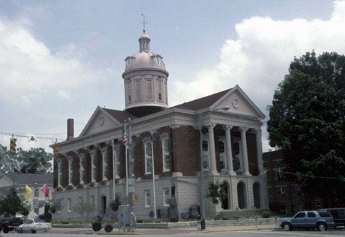


Why visit Madison
Townapedia lists 14 museums and landmarks, 12 parks and trails, 29 places to eat, 10 places to stay and 9 attractions in and around town.
Highlights include Madison 6 Theatre, Clifty Falls State Park, Charles L. Shrewsbury House and Crawford-Whitehead-Ross House.
July is the warmest month, with average highs of 88°F; January lows average 24°F.
Weather in Madison
Forecast from the National Weather Service. Full forecast
About Madison
Madison is a city in and the county seat of Jefferson County, Indiana, United States, along the Ohio River. As of the 2020 census, Madison had a population of 12,357. Over 55,000 people live within 15 miles (24 km) of downtown Madison. Madison is the largest city along the Ohio River between Louisville and Cincinnati.
From the Wikipedia article Madison, Indiana (this version), under CC BY-SA 4.0.
Things to do9


Clifty Falls State Park
Waterfall · 1.2 mi
State park in Indiana, United States

Milton–Madison Bridge
Bridge · 2.6 mi
Continuous truss bridge across the Ohio river, opened in 2014


Museums and landmarks14

Charles L. Shrewsbury House
Museum · National Register of Historic Places · 1.8 mi
Historic house museum in Madison, Indiana

Crawford-Whitehead-Ross House
Monument and historic site · National Register of Historic Places · 1.6 mi
Madison, Indiana, listed on the NRHP in Indiana

Ginn's Furniture Store
Monument and historic site · National Register of Historic Places · 2.8 mi
Commercial building in Milton, Kentucky

Jefferson County Jail
Monument and historic site · National Register of Historic Places · 1.9 mi
Historic jail and residence located in Madison, Indiana, United States
Lanier Mansion
Museum · National Register of Historic Places · 1.7 mi
Historic home in Madison, Indiana

Lemuel Allen Farm
Monument and historic site · National Register of Historic Places · 4.3 mi
Building in Indiana, United States

Madison Historic District
Monument and historic site · National Register of Historic Places · 1.6 mi
Historic district located in Madison, Indiana

Milton Masonic Lodge and County General Store
Monument and historic site · National Register of Historic Places · 2.8 mi
Department store in Milton, United States of America

Thomas A. Hendricks Library
Monument and historic site · National Register of Historic Places · 4.6 mi
Academic building at Hanover College

Dr. W.D. Hutchings' Office and Museum
Museum · 1.7 mi
120 West 3rd Street, Madison
2 more on the map.
Parks, trails and playgrounds12





Restaurants and cafes29

Steel & Steam Coffee Company
Cafe · 1.3 mi
Steel & Steam Coffee Company, based in Madison, IN, is your premier destination for exceptional coffee experiences. Specializing in...
2615 Wilson Avenue, Madison
Su closed, Mo-Fr 07:00-19:00, Sa 08:00-14:00
The Attic Coffee Mill Cafe
Cafe · Coffee Shop, Pastry, Breakfast · 1.6 mi
631 West Main Street
Mo-Fr 07:00-16:00; Sa 07:00-17:00

Off Broadway Taproom
Restaurant · Wings, Tacos, Burger, Sandwich, Salad, American, Regional · 1.9 mi
218 East Main Street

Central Hotel
Bar and pub · 1.9 mi
301 Mulberry St, Madison
Mo-Su 07:00-03:00
The Downtowner
Restaurant · 1.8 mi
Mo-Th 10:30-19:00; Fr,Sa 10:30-20:00; Su 10:30-18:00

17 more on the map.
History
Madison was laid out and platted in 1810, and the first lots were sold in 1811 by John Paul. It had busy early years due to heavy river traffic and its position as an entry point into the Indiana Territory along the historic Old Michigan Road. Madison's location across the Ohio River from Kentucky, a slave state, made it an important location on the Underground Railroad, which worked to free fugitive slaves. George DeBaptiste's barbershop in town became a nerve center of the local group. By 1850, Madison was the third-largest city in Indiana (after New Albany and Indianapolis), and among the 100 largest cities in the U.S.
From the History section of Madison, Indiana on Wikipedia, under CC BY-SA 4.0.
Where to stay10
Churches and places of worship2
Shopping5
Gas and EV charging7
Schools, colleges and libraries13
Christian Academy of Madison, Indiana
School · 1.8 mi
477 West Hutchinson Lane, Madison
Healthcare2
Map of Madison
103 places. The map loads OpenStreetMap tiles when you open it.
Climate by month
Monthly table
| Month | High | Low | Rain | Snow |
|---|---|---|---|---|
| Jan | 42°F | 24°F | 3.5 in | 4.4 in |
| Feb | 46°F | 25°F | 3.1 in | 3.6 in |
| Mar | 57°F | 33°F | 4.5 in | 1.0 in |
| Apr | 68°F | 43°F | 5.5 in | 0.1 in |
| May | 77°F | 54°F | 5.4 in | 0.0 in |
| Jun | 84°F | 62°F | 5.0 in | 0.0 in |
| Jul | 88°F | 66°F | 4.8 in | 0.0 in |
| Aug | 87°F | 65°F | 4.2 in | 0.0 in |
| Sep | 81°F | 58°F | 3.5 in | 0.0 in |
| Oct | 70°F | 46°F | 3.6 in | 0.2 in |
| Nov | 57°F | 35°F | 3.6 in | 0.0 in |
| Dec | 46°F | 29°F | 4.2 in | 3.0 in |
U.S. Climate Normals 1991-2020 for Madison Sewage Plt Hcn (2 mi away), NOAA NCEI.
People and cost of living
American Community Survey 5-year estimates, 2020-2024, U.S. Census Bureau. Estimates have margins of error, larger for small towns.
Disaster history
Jefferson County has had 16 federal disaster declarations since 2000, most often for severe storms.
- 2026-08-15: Severe Storms, Straight-Line Winds, Tornadoes, And Flooding (Flood)
- 2026-01-24: Severe Winter Storm (Winter Storm)
- 2025-07-22: Severe Storms, Straight-Line Winds, Tornadoes, And Flooding (Flood)
- 2020-04-03: Covid-19 Pandemic (Biological)
- 2020-03-13: Covid-19 (Biological)
- 2018-05-04: Severe Storms And Flooding (Flood)
OpenFEMA disaster declarations summaries.
Getting there and nearby towns
Madison Regional Airport (MDN) is the nearest airport with scheduled flights listed in OpenStreetMap, 4 miles away.
- Jeffersonville 33 mi southwest, about 54 min by car
- Clarksville 36 mi southwest, about 58 min by car
- Greensburg 41 mi north, about 1 h by car
- Columbus 42 mi northwest, about 1 h by car
- Louisville/Jefferson County 43 mi south, about 1 h 15 min by car
- Mack 47 mi northeast, about 1 h 15 min by car
- Harrison 48 mi northeast, about 1 h 15 min by car
- Bridgetown 49 mi northeast, about 1 h 15 min by car
- Dent 50 mi northeast, about 1 h 15 min by car
- Cincinnati 55 mi northeast, about 1 h 30 min by car
Drive times are estimates from straight-line distance, not routes.
Local news
Headlines from INDB, the NEMICO news database.
Reviews, tips and questions
Loading what members have shared...
Sources and licences
- NCES EDGE (Public domain): public schools
- NOAA NCEI U.S. Climate Normals 1991-2020 (Public domain): climate by month
- OpenFEMA (Public domain): disaster declarations
- OpenStreetMap contributors (ODbL 1.0): places, airports, map data
- U.S. Census Bureau (Public domain): population, income, housing, education, commute
- Wikidata (CC0 1.0): elevation, founding date, time zone, website, landmarks and historic places
- Wikimedia Commons (see each image): photos
- Wikipedia (CC BY-SA 4.0): overview and history text
Photo credits
- Jefferson County Indiana Courthouse, Photo by Calvin Beale , as an employee of the Economic Research Service, part of the United States Department of Agriculture., Public domain
- Lanier Mansion, Unknown author, CC BY 2.0
- Charles L. Shrewsbury House from southeast, Nyttend, Public domain
- Hendricks Hall, Hanover College, Nyttend, Public domain
- Jefferson County Jail in Madison, Nyttend, Public domain
- Lemuel Allen Farm, Nyttend, Public domain
- Crawford-Whitehead-Ross House, Nyttend, Public domain
- Schofield House, The original uploader was Bedford at English Wikipedia ., Attribution
- Milton Masonic Lodge and County General Store, Nyttend, Public domain
- Ginn's Furniture Store in Milton, Nyttend, Public domain
- Clifty Falls at Clifty Falls State Park, Chris Light ( talk ), CC BY-SA 3.0
- Milton–Madison Bridge 2024b, Antony-22, CC BY-SA 4.0
Page built October 30, 2026. Spotted a mistake? Tell us or suggest a place.