


Marlton, New Jersey
Marlton is a community of 10,922 people in Burlington County, New Jersey, founded in 1676.
Why visit Marlton
Townapedia lists 13 museums and landmarks, 10 parks and trails, 66 places to eat, 8 places to stay and 3 attractions in and around town.
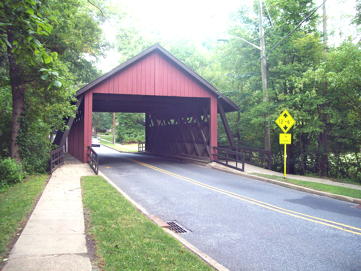
Highlights include AMC Marlton 8, Scarborough Bridge, Cropwell Friends Meeting House and Amos Evans House.
July is the warmest month, with average highs of 88°F; January lows average 26°F.
Weather in Marlton
Forecast from the National Weather Service. Full forecast
About Marlton
Marlton is a census-designated place (CDP) located within Evesham Township in Burlington County, in the U.S. state of New Jersey. As of the 2020 United States census, the CDP had a population of 10,594 residents, reflecting a 4.5% increase from the 10,133 enumerated at the 2010 U.S. census, in turn a 1.2% decrease from the 10,260 counted in the 2000 census.
From the Wikipedia article Marlton, New Jersey (this version), under CC BY-SA 4.0.
Things to do3


Museums and landmarks13

Cropwell Friends Meeting House
Monument and historic site · Quaker · National Register of Historic Places · 0.7 mi
Historic Quaker meeting house Cropwell
810 South Cropwell Road, Marlton

Amos Evans House
Monument and historic site · National Register of Historic Places · 2.1 mi
Historic house in Burlington County, New Jersey

Barclay Farm House
Monument and historic site · National Register of Historic Places · 3.7 mi
House in Cherry Hill, New Jersey

Evans-Cooper House
Monument and historic site · National Register of Historic Places · 2.5 mi
Historic house in Burlington County, New Jersey

Evesham Friends Meeting House
Monument and historic site · National Register of Historic Places · 3.0 mi
Historic Quaker meeting house in Burlington County, New Jersey

Jacob Wills House
Monument and historic site · National Register of Historic Places · 2.2 mi
Historic house in Burlington County, New Jersey

John Inskeep Homestead
Monument and historic site · National Register of Historic Places · 0.7 mi
Historic house in Burlington County, New Jersey
Paulsdale
Monument and historic site · National Register of Historic Places · 3.8 mi
Historic house in Mount Laurel, New Jersey

Samuel Coles House
Monument and historic site · National Register of Historic Places · 2.7 mi
Historic house in New Jersey, United States
Stokes-Evans House
Monument and historic site · National Register of Historic Places · 1.0 mi
Building in New Jersey, United States

Thomas and Mary Evens House
Monument and historic site · National Register of Historic Places · 2.6 mi
Historic house in Burlington County, New Jersey


Thomas Hollinshead House
Monument and historic site · National Register of Historic Places · 0.8 mi
Historic house in Burlington County, New Jersey
1 more on the map.
Parks, trails and playgrounds10



Restaurants and cafes66


Ciconte's Italia Pizza
Restaurant · Pizza · 0.8 mi
915 Route 70 West, Marlton
Su-We 11:00-21:00; Th-Sa 11:00-22:00
Grace Bistro
Restaurant · Asian · 0.9 mi
65 State Route 70, Marlton
Mo-Th 10:45-22:00; Fr,Sa 11:00-23:00; Su 12:00-22:00
House of Biryanis and Kebabs
Restaurant · Indian · 1.1 mi
2091 Marlton Turnpike, Cherry Hill Township
Mo-Th 11:30-14:30, 17:30-22:00; Fr-Sa 11:30-15:00, 17:00-22:30; Su...
Luigi's Pizza Fresca
Restaurant · Pizza, Italian · 0.6 mi
529 Old Marlton Pike West, Marlton
Mo-Sa 10:00-21:15; Su 12:00-21:00
54 more on the map.
History
Marlton was founded by Welsh and English farmers beginning in 1676. The name Marlton first appeared in the early 19th century. The name is derived from marl clay, which is commonly found in the local soil. The discovery of the marl content helped local business and farmers, and caused the first "building boom", occurring in the 1830s and 1840s. Marl continued to be excavated in Marlton until 1930, when the pits were shut down. The marl was sold locally, and shipped directly, by rail to Burlington City, Philadelphia, Pennsylvania, and Atlantic City, for reshipping as an alternate for green manure, water treatment amendment, and semi-flowable fill.
From the History section of Marlton, New Jersey on Wikipedia, under CC BY-SA 4.0.
Where to stay8
Holiday Inn Express & Suites Philadelphia - Mt. Laurel
Motel and hotel · 1.3 mi
6000 Crawford Place, Mount Laurel
Extended Stay America - Philadelphia - Mt. Laurel - Crawford Place
Motel and hotel · 1.4 mi
101 Diemer Drive, Mount Laurel
Extended Stay America - Philadelphia - Mt. Laurel - Pacilli Place
Motel and hotel · 1.4 mi
500 Diemer Drive, Mount Laurel
Sonesta Simply Suites Philadelphia Mount Laurel
Motel and hotel · 1.4 mi
4000 Crawford Place, Mount Laurel
Churches and places of worship6
Shopping13
Gas and EV charging9
Schools, colleges and libraries54
A. Russell Knight Elementary School
School · 4.3 mi
140 Old Carriage Rd., Cherry Hill
Burlington County Alternative High School
School · 5.1 mi
1020 Briggs Road, Mt. Laurel
Clara Barton Elementary School
School · 4.7 mi
223 Rhode Island Ave., Cherry Hill
Healthcare14
South Jersey Health and Wellness Center
Clinic and pharmacy · 1.9 mi
1919 Greentree Road, Cherry Hill
Allergy & Asthma Associates
Clinic and pharmacy · 1.8 mi
525 State Route 73, Evesham
Cooper Bone & Joint Intitute
Clinic and pharmacy · 1.8 mi
525 State Route 73, Evesham
Cornerstone Foot & Ankle
Clinic and pharmacy · 1.8 mi
525 State Route 73, Evesham
Kirshner Spine Institute
Clinic and pharmacy · 1.9 mi
525 State Route 73, Evesham
Mellul Facial Plastic Surgery
Clinic and pharmacy · 1.8 mi
525 State Route 73, Evesham
Passport Health Marlton Travel Clinic
Clinic and pharmacy · 0.7 mi
102C Centre Boulevard, Marlton
Map of Marlton
196 places. The map loads OpenStreetMap tiles when you open it.
Climate by month
Monthly table
| Month | High | Low | Rain |
|---|---|---|---|
| Jan | 43°F | 26°F | 3.9 in |
| Feb | 46°F | 27°F | 2.7 in |
| Mar | 54°F | 34°F | 4.6 in |
| Apr | 66°F | 43°F | 3.7 in |
| May | 75°F | 52°F | 3.6 in |
| Jun | 84°F | 62°F | 4.4 in |
| Jul | 88°F | 67°F | 5.4 in |
| Aug | 85°F | 64°F | 4.6 in |
| Sep | 80°F | 59°F | 4.2 in |
| Oct | 68°F | 47°F | 4.1 in |
| Nov | 56°F | 37°F | 3.5 in |
| Dec | 47°F | 31°F | 4.5 in |
U.S. Climate Normals 1991-2020 for Moorestown Hcn (4 mi away), NOAA NCEI.
People and cost of living
American Community Survey 5-year estimates, 2020-2024, U.S. Census Bureau. Estimates have margins of error, larger for small towns.
Disaster history
Burlington County has had 23 federal disaster declarations since 2000, most often for hurricanes.
- 2021-09-05: Remnants Of Hurricane Ida (Hurricane)
- 2021-09-02: Remnants Of Hurricane Ida (Hurricane)
- 2020-12-11: Tropical Storm Isaias (Hurricane)
- 2020-03-25: Covid-19 Pandemic (Biological)
- 2020-03-13: Covid-19 (Biological)
- 2018-06-08: Severe Winter Storm And Snowstorm (Severe Storm)
OpenFEMA disaster declarations summaries.
Getting there and nearby towns
South Jersey Regional Airport (LLY) is the nearest airport with scheduled flights listed in OpenStreetMap, 5 miles away.
- Greentree 2 mi west, about 3 min by car
- Cherry Hill Mall 5 mi northwest, about 8 min by car
- Echelon 5 mi southwest, about 8 min by car
- Haddonfield 6 mi west, about 9 min by car
- Collingswood 8 mi west, about 13 min by car
- Bellmawr 9 mi west, about 15 min by car
- Gloucester City 10 mi west, about 16 min by car
- Philadelphia 13 mi northwest, about 21 min by car
- Hammonton 19 mi southeast, about 30 min by car
- Hamilton Square 27 mi northeast, about 43 min by car
Drive times are estimates from straight-line distance, not routes.
Local news
Headlines from INDB, the NEMICO news database.
Reviews, tips and questions
Loading what members have shared...
Sources and licences
- NCES EDGE (Public domain): public schools
- NOAA NCEI U.S. Climate Normals 1991-2020 (Public domain): climate by month
- OpenFEMA (Public domain): disaster declarations
- OpenStreetMap contributors (ODbL 1.0): places, airports, map data
- U.S. Census Bureau (Public domain): population, income, housing, education, commute
- Wikidata (CC0 1.0): elevation, founding date, time zone, website, landmarks and historic places
- Wikimedia Commons (see each image): photos
- Wikipedia (CC BY-SA 4.0): overview and history text
Photo credits
- John Inskeep Homestead (3), Apc106, CC BY-SA 3.0
- Bonefish Grill restaurant interior in Marlton, New Jersey 03, Harrison Keely, CC BY 4.0
- Bonefish Grill restaurant interior in Marlton, New Jersey 02, Harrison Keely, CC BY 4.0
- Bonefish Grill restaurant bar in Marlton, New Jersey 05, Harrison Keely, CC BY 4.0
- Bonefish Grill restaurant bar in Marlton, New Jersey 04, Harrison Keely, CC BY 4.0
- Bonefish Grill restaurant exterior in Marlton, New Jersey 01, Harrison Keely, CC BY 4.0
- 2020-09-04 10 44 42 View west along New Jersey State Route 70 (Marlton Pike) at the exit for New Jersey State Route 73 SOUTH (Atlantic City, Old Marlton Pike) in Evesham Township, Burlington County..., Famartin, CC BY-SA 4.0
- 2018-05-23 14 15 01 View south along New Jersey State Route 73 at Burlington County Route 600 (Old Marlton Pike-Main Street) in Evesham Township, Burlington County, New Jersey, Famartin, CC BY-SA 4.0
- Kitchen Renovation Marlton New Jersey, SAH Builders Marlton NJ, CC BY-SA 4.0
- CROPWELL FRIENDS MEETING HOUSE - MARLTON - NJ, Jerrye and Roy Klotz MD, CC BY-SA 3.0
- Amos Evans House, apc106, CC BY-SA 3.0
- Evans - Cooper House (5), Apc106, CC BY-SA 3.0
- Thomas & Mary Evens House (3), Apc106, CC BY-SA 3.0
- BARCLAY FARM HOUSE, JERRYE & ROY KLOTZ MD, CC BY-SA 3.0
- Evesham Friends Meeting House (5), Apc106, CC BY-SA 3.0
- COLES HOUSE, JERRYE & ROY KLOTZ MD, CC BY-SA 3.0
- THOMAS HOLLINSHEAD HOUSE, MARLTON, BURLINGTON COUNTY, JERRYE AND ROY KLOTZ MD, CC BY-SA 3.0
- William & Susan Evans House (5), Apc106, CC BY-SA 3.0
- JACOB WILLS HOUSE - MARLTON - NJ, JERRYE AND ROY KLOTZ MD, CC BY-SA 3.0
- Barclaycoveredbridge, User:JSF0864, CC BY 2.0
- 2020-09-07 13 51 13 View south along New Jersey State Route 73 at the exit for New Jersey State Route 70 (Cherry Hill, Medford) in Evesham Township, Burlington County, New Jersey, Famartin, CC BY-SA 4.0
- Spring Constant Experiment, Jhs190, CC BY-SA 4.0
- 2021-08-30 16 59 32 View west along New Jersey State Route 70 from the overpass for New Jersey State Route 73 in Evesham Township, Burlington County, New Jersey, Famartin, CC BY-SA 4.0
- 2021-08-30 17 02 13 View east along New Jersey State Route 70 from the overpass for New Jersey State Route 73 in Evesham Township, Burlington County, New Jersey, Famartin, CC BY-SA 4.0
- 2020-09-04 10 43 08 View east along New Jersey State Route 70 at the exit for New Jersey State Route 73 NORTH (TO New Jersey Turnpike, Palmyra, Tacony Bridge) in Evesham Township, Burlington County..., Famartin, CC BY-SA 4.0
- 2020-09-04 15 31 07 View east along New Jersey State Route 70 at the exit for New Jersey State Route 73 SOUTH (Atlantic City Expressway) in Evesham Township, Burlington County, New Jersey, Famartin, CC BY-SA 4.0
- 2020-09-04 15 31 42 View east along New Jersey State Route 70 at the exit for New Jersey State Route 73 NORTH (TO New Jersey Turnpike, Tacony Bridge, Main Street) in Evesham Township, Burlington..., Famartin, CC BY-SA 4.0
- 2018-05-22 11 06 25 View east along New Jersey State Route 70 at New Jersey State Route 73 in Evesham Township, Burlington County, New Jersey, Famartin, CC BY-SA 4.0
- Blizzard of 2009 part 2 - panoramio, TheSituation21, CC BY 3.0
- Blizzard 2009 part 1 - panoramio, TheSituation21, CC BY 3.0
- Blizzard of 2009 part 3 - panoramio, TheSituation21, CC BY 3.0
- Blizzard '10 part 1 - panoramio, TheSituation21, CC BY 3.0
- 2020-09-07 11 15 41 View north along New Jersey State Route 73 at the exit for New Jersey State Route 70 (Cherry Hill, Medford) in Evesham Township, Burlington County, New Jersey, Famartin, CC BY-SA 4.0
- Stokes- Evans House (1), Apc106, CC BY-SA 3.0
- Stokes- Evans House, Apc106, CC BY-SA 3.0
- 2018-05-22 10 59 46 View west along New Jersey State Route 70 at Plymouth Drive in Evesham Township, Burlington County, New Jersey, Famartin, CC BY-SA 4.0
- Copper(I) Chloride Precipitate, Brandon Burghardt, Public domain
- Hampton Inn hotel in Mount Laurel, New Jersey 04, Harrison Keely, CC BY 4.0
- Hampton Inn hotel in Mount Laurel, New Jersey 02, Harrison Keely, CC BY 4.0
- Hampton Inn hotel in Mount Laurel, New Jersey 03, Harrison Keely, CC BY 4.0


Page built October 30, 2026. Spotted a mistake? Tell us or suggest a place.