


Maybrook, New York
Maybrook is a village of 3,142 people in Orange County, New York, founded in 1926.
Why visit Maybrook
Townapedia lists 18 museums and landmarks, 2 parks and trails, 3 places to eat, 1 place to stay and 2 attractions in and around town.
Highlights include Bodine's Bridge, Ward's Bridge, African-American Cemetery and Bridge Street Historic District.
July is the warmest month, with average highs of 84°F; January lows average 17°F.
Weather in Maybrook
Forecast from the National Weather Service. Full forecast
About Maybrook
Maybrook is a village in Orange County, New York, United States. The population was 3,150 at the 2020 census. It is part of the Kiryas Joel-Poughkeepsie–Newburgh, NY Metropolitan Statistical Area as well as the larger New York–Newark–Bridgeport, NY-NJ-CT-PA Combined Statistical Area.
From the Wikipedia article Maybrook, New York (this version), under CC BY-SA 4.0.
Things to do2


Museums and landmarks18

African-American Cemetery
Monument and historic site · National Register of Historic Places · 2.4 mi
Historic cemetery in Montgomery, New York

Bridge Street Historic District
Monument and historic site · National Register of Historic Places · 3.0 mi
Listed on the NRHP in New York

Daniel Waring House
Monument and historic site · National Register of Historic Places · 3.1 mi
Historic house in New York, United States

Gideon Pelton Farm
Monument and historic site · National Register of Historic Places · 1.8 mi
Historic house in New York, United States

Harrison Meeting House Site and Cemetery
Monument and historic site · National Register of Historic Places · 2.6 mi
Historic cemetery in Orange County, New York

Johannes Miller House
Monument and historic site · National Register of Historic Places · 2.6 mi
Historic house in New York, United States
John A. Crabtree House
Monument and historic site · National Register of Historic Places · 2.9 mi
Historic house in New York, United States

John Blake House
Monument and historic site · National Register of Historic Places · 0.4 mi
Maybrook, NY, listed on the NRHP in Orange County, New York

Milliken-Smith Farm
Monument and historic site · National Register of Historic Places · 3.2 mi
Historic house in New York, United States

Montgomery Water Works
Monument and historic site · National Register of Historic Places · 2.6 mi
Historic building in Montgomery, New York, United States
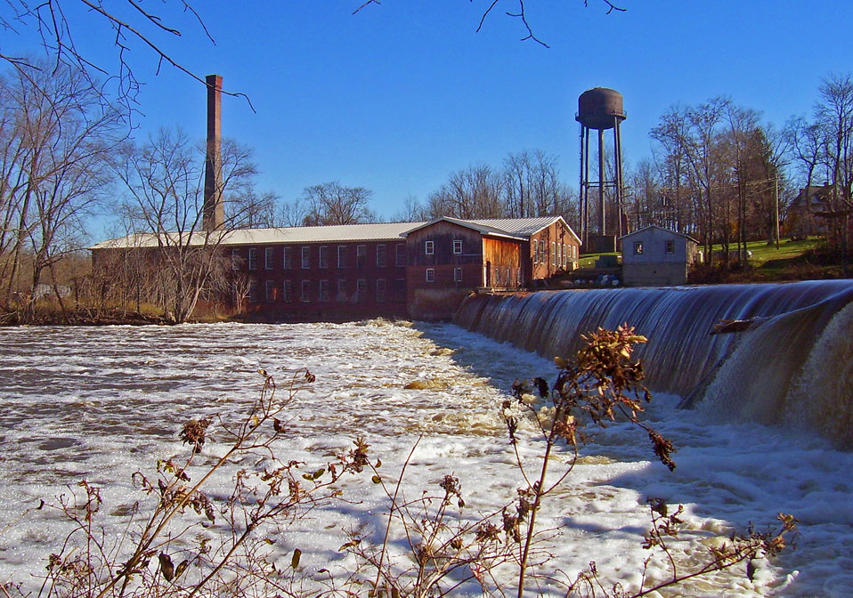
Montgomery Worsted Mills
Monument and historic site · National Register of Historic Places · 3.0 mi
Watermill in Montgomery, United States of America


Nathaniel Hill Brick House
Monument and historic site · National Register of Historic Places · 3.2 mi
Historic house in New York, United States
6 more on the map.
Parks, trails and playgrounds2


Restaurants and cafes3


The Main Line Diner & Pizza Company
Restaurant · 0.6 mi
940 Homestead Avenue, Maybrook

History
The hamlet was not incorporated as a village until 1926, making it the last of the town of Montgomery's three villages to be created. Its growth was spurred by the development of Maybrook Yard, an important railroad switching terminal where eastbound traffic from several railroads was funneled across the Poughkeepsie Bridge. At its peak, the yard employed over 1,500 workers. All yards, terminals and roundhouses have since been removed following the closing of the Poughkeepsie Bridge in 1974. There remains freight service to Maybrook via the Middletown and New Jersey Railroad.
From the History section of Maybrook, New York on Wikipedia, under CC BY-SA 4.0.
Where to stay1
Shopping1
Gas and EV charging4
Schools, colleges and libraries10
Little Britain Elementary School
School · 5.5 mi
1160 Little Britain Rd, New Windsor
Map of Maybrook
41 places. The map loads OpenStreetMap tiles when you open it.
Climate by month
Monthly table
| Month | High | Low | Rain |
|---|---|---|---|
| Jan | 35°F | 17°F | 2.4 in |
| Feb | 38°F | 18°F | 2.4 in |
| Mar | 47°F | 27°F | 3.2 in |
| Apr | 60°F | 36°F | 3.5 in |
| May | 70°F | 47°F | 3.4 in |
| Jun | 79°F | 56°F | 4.3 in |
| Jul | 84°F | 61°F | 3.3 in |
| Aug | 82°F | 59°F | 4.4 in |
| Sep | 74°F | 51°F | 3.9 in |
| Oct | 62°F | 40°F | 3.7 in |
| Nov | 50°F | 31°F | 3.0 in |
| Dec | 39°F | 23°F | 3.4 in |
U.S. Climate Normals 1991-2020 for Montgomery Orange Ap (3 mi away), NOAA NCEI.
People and cost of living
American Community Survey 5-year estimates, 2020-2024, U.S. Census Bureau. Estimates have margins of error, larger for small towns.
Disaster history
Orange County has had 26 federal disaster declarations since 2000, most often for severe storms.
- 2024-11-15: Jennings Creek Fire (Fire)
- 2023-07-22: Severe Storms And Flooding (Severe Storm)
- 2021-09-05: Remnants Of Hurricane Ida (Hurricane)
- 2021-09-02: Remnants Of Hurricane Ida (Hurricane)
- 2021-08-22: Hurricane Henri (Hurricane)
- 2020-03-20: Covid-19 Pandemic (Biological)
OpenFEMA disaster declarations summaries.
Getting there and nearby towns
Orange County Airport (MGJ) is the nearest airport with scheduled flights listed in OpenStreetMap, 3 miles away.
- Beaver Dam Lake 6 mi southeast, about 9 min by car
- Scotchtown 8 mi west, about 13 min by car
- Goshen 8 mi southwest, about 13 min by car
- Mountain Lodge Park 8 mi southeast, about 13 min by car
- Gardnertown 9 mi northeast, about 14 min by car
- Wallkill 9 mi north, about 14 min by car
- Newburgh 10 mi east, about 16 min by car
- Chester 10 mi south, about 16 min by car
- Firthcliffe 10 mi east, about 16 min by car
- Kiryas Joel 11 mi south, about 17 min by car
Drive times are estimates from straight-line distance, not routes.
Local news
Headlines from INDB, the NEMICO news database.
Reviews, tips and questions
Loading what members have shared...
Sources and licences
- NCES EDGE (Public domain): public schools
- NOAA NCEI U.S. Climate Normals 1991-2020 (Public domain): climate by month
- OpenFEMA (Public domain): disaster declarations
- OpenStreetMap contributors (ODbL 1.0): places, airports, map data
- U.S. Census Bureau (Public domain): population, income, housing, education, commute
- Wikidata (CC0 1.0): elevation, founding date, time zone, website, landmarks and historic places
- Wikimedia Commons (see each image): photos
- Wikipedia (CC BY-SA 4.0): overview and history text
Photo credits
- Drury Lane exit construction, The original uploader was Daniel Case at English Wikipedia ., CC BY-SA 3.0
- Maybrook, NY, village hall, Daniel Case, CC BY-SA 3.0
- NY 208 nb in Maybrook (2), July 2024, Mr. Matté (if there is an issue with this image, contact me using this image's Commons talk page , my Commons user talk page , or my English Wikipedia user talk page ; I'll know about it a lot faster), CC BY-SA 4.0
- NY 208 nb in Maybrook (1), July 2024, Mr. Matté (if there is an issue with this image, contact me using this image's Commons talk page , my Commons user talk page , or my English Wikipedia user talk page ; I'll know about it a lot faster), CC BY-SA 4.0
- NY 208 nb entering Maybrook, July 2024, Mr. Matté (if there is an issue with this image, contact me using this image's Commons talk page , my Commons user talk page , or my English Wikipedia user talk page ; I'll know about it a lot faster), CC BY-SA 4.0
- Maybrook, NY caboose, July 2024, Mr. Matté (if there is an issue with this image, contact me using this image's Commons talk page , my Commons user talk page , or my English Wikipedia user talk page ; I'll know about it a lot faster), CC BY-SA 4.0
- Exhuming the First American Mastodon . label QS:Len,"Exhuming the First American Mastodon ." label QS:Lde,"Die Ausgrabung des Mammuts", Charles Willson Peale, Public domain
- Tweddle Farmstead, The original uploader was Daniel Case at English Wikipedia ., CC BY-SA 3.0
- Johannes Miller House, Daniel Case, CC BY-SA 3.0
- Harrison Meeting site, The original uploader was Daniel Case at English Wikipedia ., CC BY-SA 3.0
- Patchett House, Daniel Case at English Wikipedia, CC BY-SA 3.0
- John Blake House 2, Daniel Case, CC BY-SA 3.0
- MILLIKEN SMITH FARM IN MONTGOMERY, ORANGE COUNTY, NY, JERRYE & ROY KLOTZ M.D., CC BY-SA 4.0
- Bridge Street, Montgomery NY, Daniel Case at English Wikipedia, CC BY-SA 3.0
- Gideon Pelton Farm, The original uploader was Daniel Case at English Wikipedia ., CC BY-SA 3.0
- Montgomery Worsted Mills, Daniel Case at English Wikipedia, CC BY-SA 3.0
- Nathaniel Hill Brick House, The original uploader was Daniel Case at English Wikipedia ., CC BY-SA 3.0
- Indian Hill, Montgomery, NY, Original uploader was Daniel Case at en.wikipedia, CC BY-SA 3.0
- Montgomery Water Works, Daniel Case at English Wikipedia, CC BY-SA 3.0
- Historic Union Street houses, Montgomery, NY, Daniel Case, CC BY-SA 3.0
- Bodine's Bridge, Daniel Case, CC BY-SA 3.0
- Ward's Bridge 2, Daniel Case, CC BY-SA 3.0
- Orange County Transit ^02031 - Flickr - nybuspics, nybuspics, CC BY 2.0
- Jacob and Caroline Hawkins House, Hamptonburgh, NY, Daniel Case, CC BY-SA 3.0
- ISS017-E-5245 - View of New Jersey, Earth Science and Remote Sensing Unit , Lyndon B. Johnson Space Center, Public domain
- Longitudinal view of Speedway station canopy at night, Montgomery, NY, Daniel Case, CC BY-SA 3.0


Page built October 30, 2026. Spotted a mistake? Tell us or suggest a place.