


Why visit Mayo
Townapedia lists 12 museums and landmarks, 22 parks and trails, 5 places to eat, 1 place to stay and 3 attractions in and around town.
Highlights include Thomas Point Shoal Light, Wild Kid Acres, Capt. Salem Avery House and Cedar Park.
July is the warmest month, with average highs of 86°F; January lows average 30°F.
Weather in Mayo
Forecast from the National Weather Service. Full forecast
About Mayo
Mayo is a census-designated place (CDP) in Anne Arundel County, Maryland, United States. The population was 8,298 in the 2010 census. The Mayo CDP of 2010 includes all of the area that used to be counted as the Selby-on-the-Bay CDP. The beach in Mayo used to be a popular weekend resort.
From the Wikipedia article Mayo, Maryland (this version), under CC BY-SA 4.0.
Things to do3
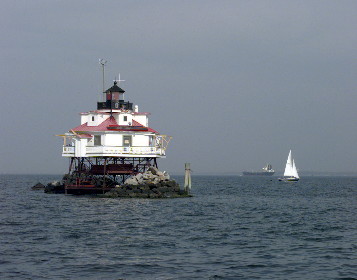
Thomas Point Shoal Light
Lighthouse · National Register of Historic Places · 4.2 mi
Lighthouse in Maryland, United States


Museums and landmarks12

Capt. Salem Avery House
Museum · National Register of Historic Places · 3.6 mi
Archive organization in Shady Side, United States

Cedar Park
Monument and historic site · National Register of Historic Places · 3.6 mi
Building in Anne Arundel County, Maryland, United States

Douglass Summer House
Monument and historic site · National Register of Historic Places · 3.1 mi
Historic house in Maryland, United States

Gresham
Monument and historic site · National Register of Historic Places · 0.9 mi
House near Edgewater, Maryland
Larkin's Hundred
Monument and historic site · National Register of Historic Places · 3.9 mi
Building in Anne Arundel County, Maryland, United States

London Town Publik House
Monument and historic site · National Register of Historic Places · 3.0 mi
House in Anne Arundel County, United States of America

Parkhurst
Monument and historic site · National Register of Historic Places · 3.6 mi
Building in Anne Arundel County, Maryland, United States

Primrose Hill
Monument and historic site · National Register of Historic Places · 3.9 mi
Building in Maryland, United States


South River Club
Monument and historic site · National Register of Historic Places · 2.7 mi
Building in Anne Arundel County, Maryland, United States
Tulip Hill
Monument and historic site · National Register of Historic Places · 4.2 mi
Human settlement in Anne Arundel County, Maryland, United States of America

Smithsonian Environmental Research Center
Museum · 2.0 mi
Environmental research and educational facility operated by the Smithsonian Institution
Parks, trails and playgrounds22


Quiet Waters Park
Park · 2.4 mi
Park in Annapolis, United States of America
Rhode River Marina, Inc.
Marina and boat launch · 1.0 mi
3932 Germantown Road, Edgewater
Mo-Sa 08:00-17:00
Harmony Marina
Marina and boat launch · 1.1 mi
1024 Carrs Wharf Road, Edgewater
24/7
10 more on the map.
Restaurants and cafes5

AZTK COCINA
Restaurant · Mexican · 0.8 mi
827 Mayo Road, Edgewater
Mo-Sa 10:00-20:00; Su 10:00-18:00; easter -4 days off; easter -1...
Harper's Waterfront Restaurant
Restaurant · Steak House, Seafood · 0.4 mi
1107 Turkey Point Road, Edgewater
Su-Th 11:00-22:00; Fr,Sa 11:00-23:00
Old Stein Inn
Restaurant · 0.6 mi
1143 Central Avenue, Edgewater
We-Fr 16:00-21:00; Sa 12:00-21:00; Su 12:00-20:00
Angelina's Italian Kitchen and Sub Shoppe
Restaurant · Italian · 0.7 mi
827 Central Avenue E, Edgewater
Th-Su 12:00-19:00; easter -1 day 15:00-19:00

Pizza Boli's
Fast food · Pizza · 0.4 mi
947 Central Avenue, Edgewater
Mo-Th 11:00-22:00; Fr-Sa 11:00-23:00; Su 11:00-22:00
History
Mayo takes its name from Commodore Isaac Mayo, who distinguished himself in the Mexican–American War. Commodore Mayo held a large tract of land on the South River, known in the early 1900s as "Mayo's Neck", that had been the home estate of Captain Nicholas Gassaway, the son of Maryland politician Colonel Nicholas Gassaway. His home, known as Gresham, was listed on the National Register of Historic Places in 1990. Martenet's 1860 map of Anne Arundel County, Maryland shows the place name for this area to be "Scrabble Town" previous to the change to Mayo.
From the History section of Mayo, Maryland on Wikipedia, under CC BY-SA 4.0.
Where to stay1
Churches and places of worship6
All Hallows Church
Church · National Register of Historic Places · 3.7 mi
Our Lady of Perpetual Help Catholic Church
Church · Roman Catholic · 1.5 mi
515 Loch Haven Road, Edgewater
Hope United Methodist Church
Church · Methodist · 2.2 mi
3672 Muddy Creek Road, Edgewater
Shopping1
Gas and EV charging1
Schools, colleges and libraries26
Carrie Weedon Early Education Center
School · 4.5 mi
911 Galesville Road, Galesville
Map of Mayo
77 places. The map loads OpenStreetMap tiles when you open it.
Climate by month
Monthly table
| Month | High | Low | Rain |
|---|---|---|---|
| Jan | 43°F | 30°F | 2.8 in |
| Feb | 45°F | 32°F | 2.4 in |
| Mar | 53°F | 38°F | 3.8 in |
| Apr | 64°F | 47°F | 3.4 in |
| May | 73°F | 57°F | 3.1 in |
| Jun | 82°F | 68°F | 4.0 in |
| Jul | 86°F | 72°F | 4.9 in |
| Aug | 84°F | 70°F | 4.3 in |
| Sep | 77°F | 65°F | 5.1 in |
| Oct | 67°F | 52°F | 4.0 in |
| Nov | 56°F | 42°F | 3.0 in |
| Dec | 47°F | 34°F | 3.0 in |
U.S. Climate Normals 1991-2020 for Annapolis Naf (6 mi away), NOAA NCEI.
People and cost of living
American Community Survey 5-year estimates, 2020-2024, U.S. Census Bureau. Estimates have margins of error, larger for small towns.
Disaster history
Anne Arundel County has had 14 federal disaster declarations since 2000, most often for hurricanes.
- 2026-01-24: Severe Winter Storm (Winter Storm)
- 2020-03-26: Covid-19 Pandemic (Biological)
- 2020-03-13: Covid-19 (Biological)
- 2016-03-04: Severe Winter Storm And Snowstorm (Snowstorm)
- 2012-11-20: Hurricane Sandy (Hurricane)
- 2012-10-28: Hurricane Sandy (Hurricane)
OpenFEMA disaster declarations summaries.
Getting there and nearby towns
Lee Airport (ANP) is the nearest airport with scheduled flights listed in OpenStreetMap, 4 miles away.
- Annapolis Neck 2 mi north, about 4 min by car
- Edgewater 3 mi northwest, about 5 min by car
- Annapolis 5 mi north, about 8 min by car
- Galesville 5 mi southwest, about 8 min by car
- Parole 6 mi north, about 10 min by car
- Deale 8 mi south, about 13 min by car
- Crownsville 9 mi northwest, about 15 min by car
- Arnold 10 mi north, about 15 min by car
- Cape St. Claire 10 mi north, about 17 min by car
- Crofton 12 mi northwest, about 19 min by car
Drive times are estimates from straight-line distance, not routes.
Local news
Headlines from INDB, the NEMICO news database.
Reviews, tips and questions
Loading what members have shared...
Sources and licences
- NCES EDGE (Public domain): public schools
- NOAA NCEI U.S. Climate Normals 1991-2020 (Public domain): climate by month
- OpenFEMA (Public domain): disaster declarations
- OpenStreetMap contributors (ODbL 1.0): places, airports, map data
- U.S. Census Bureau (Public domain): population, income, housing, education, commute
- Wikidata (CC0 1.0): elevation, founding date, time zone, website, landmarks and historic places
- Wikimedia Commons (see each image): photos
- Wikipedia (CC BY-SA 4.0): overview and history text
Photo credits
- Cedar-Park-LOC-East-View-Showing-Entrance, Langenbach, Randolph and Pickering, E. H., Public domain
- PRIMROSE HILL, ANNAPOLIS, ANNE ARUNDEL COUNTY, MD, JERRYE & ROY KLOTZ, M.D., CC BY-SA 4.0
- All Hallows Church Jul 09, Pubdog ( talk ), Public domain
- Larkin's Hundred HABS MD1, Unknown author Unknown author, Public domain
- Capt. Salem Avery House May 10, Pubdog ( talk ), Public domain
- Douglass Summer House Dec 09, Pubdog ( talk ), Public domain
- South River Club Jul 09, Pubdog ( talk ), Public domain
- Thomas Point Lighthouse Chesapeake Bay, United States Coast Guard, PA1 Pete Milnes, Public domain
- Parkhurst Harwood MD May 10, Pubdog ( talk ), Public domain
- London Town Publik House MD2, Acroterion, CC BY-SA 4.0
- ISS053-E-252336 - View of Earth, Earth Science and Remote Sensing Unit , Lyndon B. Johnson Space Center, Public domain
- ISS047-E-70968 - View of Earth, Earth Science and Remote Sensing Unit , Lyndon B. Johnson Space Center, Public domain
- ISS047-E-70964 - View of Earth, Earth Science and Remote Sensing Unit , Lyndon B. Johnson Space Center, Public domain
- ISS047-E-67309 - View of Earth, Earth Science and Remote Sensing Unit , Lyndon B. Johnson Space Center, Public domain
- ISS047-E-70966 - View of Earth, Earth Science and Remote Sensing Unit , Lyndon B. Johnson Space Center, Public domain
- ISS047-E-70965 - View of Earth, Earth Science and Remote Sensing Unit , Lyndon B. Johnson Space Center, Public domain
- ISS053-E-255830 - View of Earth, Earth Science and Remote Sensing Unit , Lyndon B. Johnson Space Center, Public domain
- ISS047-E-67311 - View of Earth, Earth Science and Remote Sensing Unit , Lyndon B. Johnson Space Center, Public domain
- ISS053-E-239518 - View of Earth, Earth Science and Remote Sensing Unit , Lyndon B. Johnson Space Center, Public domain
- ISS022-E-8063 - View of Earth, Earth Science and Remote Sensing Unit , Lyndon B. Johnson Space Center, Public domain
- ISS047-E-70967 - View of Earth, Earth Science and Remote Sensing Unit , Lyndon B. Johnson Space Center, Public domain
- ISS035-E-41214 - View of Earth, Earth Science and Remote Sensing Unit , Lyndon B. Johnson Space Center, Public domain
- ISS019-E-19923 - View of Earth, Earth Science and Remote Sensing Unit , Lyndon B. Johnson Space Center, Public domain
- ISS059-E-104734 - View of Pennsylvania, Earth Science and Remote Sensing Unit, NASA Johnson Space Center, Public domain
- ISS047-E-70969 - View of Earth, Earth Science and Remote Sensing Unit , Lyndon B. Johnson Space Center, Public domain
- ISS062-E-79079 - View of Earth, Earth Science and Remote Sensing Unit, NASA Johnson Space Center, Public domain
- ISS047-E-67310 - View of Earth, Earth Science and Remote Sensing Unit , Lyndon B. Johnson Space Center, Public domain
- ISS035-E-41213 - View of Earth, Earth Science and Remote Sensing Unit , Lyndon B. Johnson Space Center, Public domain
- ISS053-E-255829 - View of Earth, Earth Science and Remote Sensing Unit , Lyndon B. Johnson Space Center, Public domain
- ISS019-E-19556 - View of Earth, Earth Science and Remote Sensing Unit , Lyndon B. Johnson Space Center, Public domain
- ISS053-E-252335 - View of Earth, Earth Science and Remote Sensing Unit , Lyndon B. Johnson Space Center, Public domain
- ISS047-E-67312 - View of Earth, Earth Science and Remote Sensing Unit , Lyndon B. Johnson Space Center, Public domain
- Eulepidotinae- Panopoda rufimargo (Red-lined Panopoda), Kristof Zyskowski & Yulia Bereshpolova, CC BY 2.0
- Prochoerodes lineola (Large Maple Spanworm Moth) - 43023307791, Kristof Zyskowski & Yulia Bereshpolova, CC BY 2.0
- Patalene olyzonaria (Juniper-twig Geometer, Juniper Geometer Moth), Kristof Zyskowski & Yulia Bereshpolova, CC BY 2.0
- Pleuroprucha insulsaria (Common Tan Wave), Kristof Zyskowski & Yulia Bereshpolova, CC BY 2.0
- Jumping - 3355076259, Kris S, CC BY 2.0
- Colubridae- Nerodia sipedon sipedon (Northern Water Snake) - 42962676302, Kristof Zyskowski & Yulia Bereshpolova, CC BY 2.0
- Colubridae- Nerodia sipedon sipedon (Northern Water Snake) - 42962677382, Kristof Zyskowski & Yulia Bereshpolova, CC BY 2.0
- Colubridae- Nerodia sipedon sipedon (Northern Water Snake) - 42293856484, Kristof Zyskowski & Yulia Bereshpolova, CC BY 2.0


Page built October 30, 2026. Spotted a mistake? Tell us or suggest a place.