



Mechanicsville, Maryland
Mechanicsville is a community of 1,395 people in St. Mary's County, Maryland.
Why visit Mechanicsville
Townapedia lists 1 museum or landmark in and around town.
Highlights include Charlotte Hall Historic District.
July is the warmest month, with average highs of 85°F; January lows average 25°F.
Weather in Mechanicsville
Forecast from the National Weather Service. Full forecast
About Mechanicsville
Mechanicsville is an unincorporated community and census-designated place in St. Mary's County, Maryland, United States. It is adjacent to the community of Charlotte Hall, which is known for its agriculture, Amish population, and the Maryland Veterans Home. Mechanicsville has many small businesses and restaurants along Maryland Route 5 and Maryland Route 235, as well as an enclosed Amish produce market. The community is served by the St.
From the Wikipedia article Mechanicsville, Maryland (this version), under CC BY-SA 4.0.
Museums and landmarks1

Charlotte Hall Historic District
Monument and historic site · National Register of Historic Places · 3.4 mi
Historic district in Maryland, United States
Churches and places of worship4


All Faith Church
Church · National Register of Historic Places · 2.3 mi
Church building in St. Mary's County, Maryland

Gas and EV charging2

Schools, colleges and libraries8

Lettie Marshall Dent Elem
School · 3.3 mi
37840 New Market Turner Rd, Mechanicsville
Mechanicsville Elementary School
School · 1.7 mi
28585 Three Notch Road, Mechanicsville
History
Part of the area was first settled in the 1660s by early Maryland colonists who were tobacco planters. They established some farms not far from the Patuxent river. In 1819, Cremona Farm, a 750-acre estate and plantation was built in the same location. In about 1850, "Mechanicsville Village" was established on the historic Three Notch Trail. The name "Mechanicsville" is believed to have come from the word "Mechanic" because the area became a center for blacksmiths and other craftsmen. In those days "Mechanic" meant a skilled tradesperson who worked by hands.
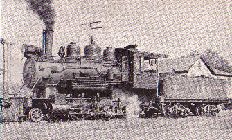
There was an old railway that passed through Mechanicsville and local residents joined other St. Mary's County residents in purchasing it and saving it from being scrapped in 1918. Farm goods moved along the railroad on train cars and passenger service continued until about 1928. By that time county roads had improved and the railway began to fall out of use.
From the History section of Mechanicsville, Maryland on Wikipedia, under CC BY-SA 4.0.
Map of Mechanicsville
15 places. The map loads OpenStreetMap tiles when you open it.
Climate by month
Monthly table
| Month | High | Low | Rain | Snow |
|---|---|---|---|---|
| Jan | 44°F | 25°F | 3.3 in | 5.0 in |
| Feb | 48°F | 26°F | 3.0 in | 6.2 in |
| Mar | 56°F | 33°F | 4.2 in | 1.8 in |
| Apr | 67°F | 42°F | 3.3 in | 0.1 in |
| May | 74°F | 52°F | 4.3 in | 0.0 in |
| Jun | 82°F | 61°F | 4.2 in | 0.0 in |
| Jul | 85°F | 66°F | 4.6 in | 0.0 in |
| Aug | 83°F | 64°F | 4.8 in | 0.0 in |
| Sep | 77°F | 58°F | 4.9 in | 0.0 in |
| Oct | 66°F | 46°F | 4.2 in | 0.0 in |
| Nov | 57°F | 36°F | 3.3 in | 0.0 in |
| Dec | 48°F | 29°F | 4.0 in | 2.0 in |
U.S. Climate Normals 1991-2020 for Mechanicsville 5 Ne (5 mi away), NOAA NCEI.
People and cost of living
American Community Survey 5-year estimates, 2020-2024, U.S. Census Bureau. Estimates have margins of error, larger for small towns.
Disaster history
St. Mary's County has had 13 federal disaster declarations since 2000, most often for hurricanes.
- 2026-01-24: Severe Winter Storm (Winter Storm)
- 2021-02-04: Tropical Storm Isaias (Hurricane)
- 2020-03-26: Covid-19 Pandemic (Biological)
- 2020-03-13: Covid-19 (Biological)
- 2012-11-20: Hurricane Sandy (Hurricane)
- 2012-10-28: Hurricane Sandy (Hurricane)
OpenFEMA disaster declarations summaries.
Getting there and nearby towns
Saint Mary's County Regional Airport (LTW) is the nearest airport with scheduled flights listed in OpenStreetMap, 13 miles away.
- Charlotte Hall 3 mi northwest, about 5 min by car
- Golden Beach 5 mi northeast, about 8 min by car
- Hughesville 8 mi north, about 13 min by car
- Leonardtown 10 mi southeast, about 17 min by car
- La Plata 14 mi northwest, about 23 min by car
- Huntingtown 14 mi northeast, about 22 min by car
- Calvert Beach 14 mi east, about 23 min by car
- Waldorf 16 mi northwest, about 25 min by car
- California 16 mi southeast, about 27 min by car
- Baden 17 mi north, about 27 min by car
Drive times are estimates from straight-line distance, not routes.
Local news
Headlines from INDB, the NEMICO news database.
Reviews, tips and questions
Loading what members have shared...
Sources and licences
- NCES EDGE (Public domain): public schools
- NOAA NCEI U.S. Climate Normals 1991-2020 (Public domain): climate by month
- OpenFEMA (Public domain): disaster declarations
- OpenStreetMap contributors (ODbL 1.0): places, airports, map data
- U.S. Census Bureau (Public domain): population, income, housing, education, commute
- Wikidata (CC0 1.0): elevation, founding date, time zone, website, landmarks and historic places
- Wikimedia Commons (see each image): photos
- Wikipedia (CC BY-SA 4.0): overview and history text
Photo credits
- Amish parking lot Mechanicsville Maryland, Bohemian Baltimore, CC BY-SA 4.0
- 2016-05-18 07 27 05 View south along Three Notch Road (Maryland State Route 235) near Point Lookout Road (Maryland State Route 5) in Mechanicsville, St. Mary's County, Maryland, Famartin, CC BY-SA 4.0
- Charlotte Hall Historic District White Hall Jul 09, Pubdog ( talk ), Public domain
- All Faith Church Jul 09, Pubdog ( talk ), Public domain
- WB&PL Engine 5, Unknown author Unknown author, Public domain
- Maryland Route 5 Northbound 1, St. Mary's County, May 31st, 2009, Joshua Kinard, CC BY-SA 3.0
- 2016-07-20 07 24 54 View north along Maryland State Route 5 (Three Notch Road) at Maryland State Route 235 (Three Notch Road) near Harpers Corners in St. Mary's County, Maryland, Famartin, CC BY-SA 4.0
- 2016-07-20 07 26 56 View south along Maryland State Route 5 (Point Lookout Road) just south of Maryland State Route 235 (Three Notch Road) near Harpers Corners in St. Mary's County, Maryland, Famartin, CC BY-SA 4.0


Page built October 30, 2026. Spotted a mistake? Tell us or suggest a place.