


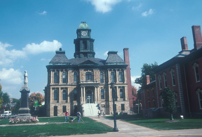


Millersburg, Ohio
Millersburg is a village of 3,206 people in Holmes County, Ohio, founded in November 1815.
Why visit Millersburg
Townapedia lists 9 museums and landmarks, 6 parks and trails, 9 places to eat and 4 places to stay in and around town.
Highlights include Brightman House and G. Adams House.
July is the warmest month, with average highs of 84°F; January lows average 18°F, and about 20 inches of snow fall in a normal year.
Weather in Millersburg
Forecast from the National Weather Service. Full forecast
About Millersburg
Millersburg is a village in Holmes County, Ohio, United States, and its county seat. Located 66 miles (106 km) south of Cleveland, it is in the heart of Ohio's Amish Country and is part of a large regional tourism industry. The population was 3,151 at the 2020 census. Holmes County Airport, located two miles southwest of Millersburg, serves the county.
From the Wikipedia article Millersburg, Ohio (this version), under CC BY-SA 4.0.
Museums and landmarks9

Brightman House
Monument and historic site · National Register of Historic Places · 0.4 mi
Building in Ohio, United States of America

G. Adams House
Monument and historic site · National Register of Historic Places
Millersburg, Ohio
Holmes County Courthouse
Monument and historic site · National Register of Historic Places
Historic government building in Millersburg, Ohio, United States

Pomerene House
Monument and historic site · National Register of Historic Places
Historic house in Berlin, Ohio, United States

Holmes County Public Library
Monument and historic site · 0.6 mi
County Public Library
Peter Myers Memorial
Monument and historic site
Beneath this stone lies Peter Myers who died January 2, 1843 Aged 80 years. The hero of three wars in the defense of the rights of man....

Parks, trails and playgrounds6

Deer Run Park
Park · 0.6 mi
Playground; recreation; soccer; grass; basketball; baseball; vollyball
2805 Glen Drive, Millersburg
Clay Street Park
Park
Previously known as Peter Myers Park in honor of the lone soldier buried at this site in 1843.

Old Airport Park
Park · 0.7 mi
A large city park that was once site of the old Millersburg airport. Now has several soccer fields, two ball fields, several tennis...
Restaurants and cafes9





Where to stay4

Holiday Inn Express & Suites Millersburg
Motel and hotel · 0.7 mi
1005 South Washington Street, Millersburg

History
The Old Town of Millersburg was laid out by Adam Johnson and Charles Miller of Coshocton County in November 1815. It was located at the north side of the northwest quarter of Section 12, township 9, range 7 adjoining the School Lands, and very near the northwest corner of said quarter section. The Northwest corner, lot 1, was a little over the hill towards the present mill dam and the northeast corner, lot 9, was about 100 steps west of the present Wooster Road. The center of the town was very nearly the center of Walkups Addition. The principal streets were Bridge, High and Market, each four rods wide. The direction of the former was east and west, and ll rods south of the school land; and was located on the State Road east and west through the county, that crosses the Killbuck near the present mill dam.
Thomas Haskins was the first settler on the town plat, settling there in the spring of 1819, on lot 21, corner of Bridge and High streets. In the spring of 1820, James Withrow erected a one-and-a-half-story building on Lot 33 cornering on Bridge and High streets and diagonally across them from the Haskins tavern.
From the History section of Millersburg, Ohio on Wikipedia, under CC BY-SA 4.0.
Churches and places of worship9
Millersburg Christian Church
Church · National Register of Historic Places
United Methodist Church
Church · National Register of Historic Places
Millersburg United Mteodest Church
Church · Methodist · 1.4 mi
Township Road 319, Millersburg
NewPointe Community Church Millersburg
Church · Nondenominational · 1.4 mi
8882 State Route 39, Millersburg
Shopping7
Gas and EV charging3
Schools, colleges and libraries10
Buckeye Career Center Annex-Hiland Satellite
School · 5.7 mi
5200 State Route 39, Millersburg
Healthcare3
Akron Children's Hospital - Millersburg Health Center
Clinic and pharmacy · 1.2 mi
1261 Wooster Road, Millersburg
Millersburg Medical Center
Clinic and pharmacy · 1.2 mi
1261 Wooster Road, Millersburg
Map of Millersburg
60 places. The map loads OpenStreetMap tiles when you open it.
Climate by month
Monthly table
| Month | High | Low | Rain | Snow |
|---|---|---|---|---|
| Jan | 36°F | 18°F | 2.9 in | 7.3 in |
| Feb | 39°F | 19°F | 2.1 in | 4.8 in |
| Mar | 49°F | 27°F | 3.1 in | 2.9 in |
| Apr | 62°F | 36°F | 3.9 in | 0.2 in |
| May | 72°F | 47°F | 4.2 in | 0.0 in |
| Jun | 80°F | 56°F | 4.9 in | 0.0 in |
| Jul | 84°F | 60°F | 4.2 in | 0.0 in |
| Aug | 82°F | 58°F | 3.4 in | 0.0 in |
| Sep | 76°F | 51°F | 3.3 in | 0.0 in |
| Oct | 65°F | 40°F | 3.1 in | 0.0 in |
| Nov | 52°F | 30°F | 2.8 in | 0.7 in |
| Dec | 40°F | 24°F | 2.9 in | 4.2 in |
U.S. Climate Normals 1991-2020 for Millersburg Hcn (1 mi away), NOAA NCEI.
People and cost of living
American Community Survey 5-year estimates, 2020-2024, U.S. Census Bureau. Estimates have margins of error, larger for small towns.
Disaster history
Holmes County has had 8 federal disaster declarations since 2000, most often for severe storms.
- 2020-03-31: Covid-19 Pandemic (Biological)
- 2020-03-13: Covid-19 (Biological)
- 2012-06-30: Severe Storms (Severe Storm)
- 2008-10-24: Severe Wind Storm Associated With Tropical Depression Ike (Severe Storm)
- 2005-09-13: Hurricane Katrina Evacuation (Hurricane)
- 2005-02-15: Severe Winter Storms, Flooding, And Mudslides (Severe Storm)
OpenFEMA disaster declarations summaries.
Getting there and nearby towns
Wayne County Airport (BJJ) is the nearest airport with scheduled flights listed in OpenStreetMap, 22 miles away.
- Berlin 6 mi east, about 10 min by car
- Walnut Creek 10 mi east, about 16 min by car
- Sugarcreek 15 mi east, about 24 min by car
- Loudonville 17 mi west, about 28 min by car
- Wooster 18 mi north, about 30 min by car
- Coshocton 20 mi south, about 33 min by car
- Brewster 20 mi northeast, about 31 min by car
- Strasburg 21 mi east, about 33 min by car
- West Lafayette 21 mi southeast, about 34 min by car
- Dover 23 mi east, about 37 min by car
Drive times are estimates from straight-line distance, not routes.
Local news
Headlines from INDB, the NEMICO news database.
Reviews, tips and questions
Loading what members have shared...
Sources and licences
- NCES EDGE (Public domain): public schools
- NOAA NCEI U.S. Climate Normals 1991-2020 (Public domain): climate by month
- OpenFEMA (Public domain): disaster declarations
- OpenStreetMap contributors (ODbL 1.0): places, airports, map data
- U.S. Census Bureau (Public domain): population, income, housing, education, commute
- Wikidata (CC0 1.0): elevation, founding date, time zone, website, landmarks and historic places
- Wikimedia Commons (see each image): photos
- Wikipedia (CC BY-SA 4.0): overview and history text
Photo credits
- Downtown Millersburg, Ohio, from the air, Nyttend, Public domain
- U Methodist Church P9020135, Chris Light ( talk ), CC BY-SA 3.0
- Holmes County Courthouse, Millersburg, Calvin Beale, Public domain
- Brightman House P5111151, Chris Light, CC BY-SA 4.0
- Adams House — Millersburg, Ohio, Christopher L. Riley, CC BY-SA 4.0
- Disciple-Christian P9020129, Chris Light ( talk ), CC BY-SA 3.0
- Pomerene Hst P9020151, Chris Light ( talk ), CC BY-SA 3.0
Page built October 30, 2026. Spotted a mistake? Tell us or suggest a place.