


Why visit Montauk
Townapedia lists 12 museums and landmarks, 17 parks and trails, 41 places to eat, 30 places to stay and 6 attractions in and around town.
Highlights include Montauk Manor, AN/FPS-35, Camp Hero State Park and Hither Woods Preserve.
July is the warmest month, with average highs of 80°F; January lows average 28°F.
Weather in Montauk
Forecast from the National Weather Service. Full forecast
About Montauk
Montauk is a hamlet and census-designated place (CDP) in East Hampton and Suffolk County, New York, on the eastern end of the South Shore of Long Island in the United States. As of the 2020 United States census, the CDP's population was 4,318.
From the Wikipedia article Montauk, New York (this version), under CC BY-SA 4.0.
Things to do6



Museums and landmarks12

Montauk Manor
Monument and historic site · National Register of Historic Places
Hotel in Montauk, United States
236 Edgemere Street, Montauk

AN/FPS-35
Monument and historic site · National Register of Historic Places · 3.9 mi
Cold War–era US early warning radar

Caleb Bragg Estate
Monument and historic site · National Register of Historic Places · 1.8 mi
Historic house in New York, United States
HMS Culloden
Monument and historic site · National Register of Historic Places · 1.9 mi
1776 Culloden-class third-rate ship of the line

Montauk Association Historic District
Monument and historic site · National Register of Historic Places · 2.1 mi
Historic district in New York, United States
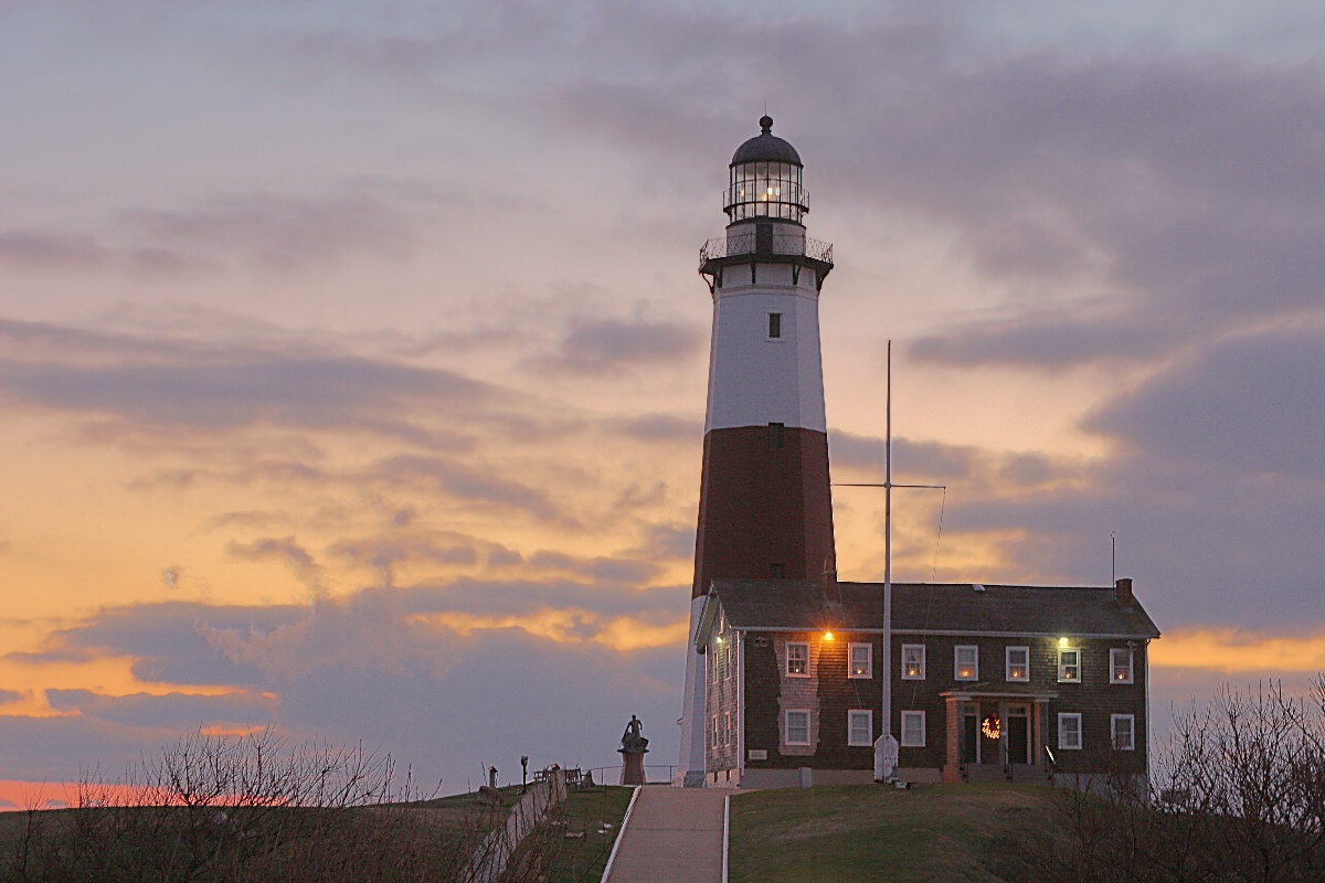
Montauk Point Light
Lighthouse · National Register of Historic Places · 4.9 mi
Lighthouse in New York, United States

Montauk Tennis Auditorium
Monument and historic site · National Register of Historic Places
Historic building in Montauk, New York, United States
Arthur W. B. Wood Windmill House
Monument and historic site · 0.6 mi
162 Fairview Avenue, Montauk
Parks, trails and playgrounds17





5 more on the map.
Restaurants and cafes41

Ruschmeyer's
Diner · American · 0.9 mi
161 Second House Road, Montauk
Mo-Su 17:30-23:00; Apr 10-15 off; Jun 08:00-14:00; Oct off; Nov...

Montauk Bake Shoppe
Bakery · 0.9 mi
29 Carl Fisher Plaza, Montauk
Su-Th 06:00-18:00; Fr-Sa 06:00-22:00


St. Peter's Catch
Restaurant · Seafood · 0.8 mi
58 South Erie Avenue, Montauk
Mo-Su 09:00-21:00

29 more on the map.
Where to stay30
Royal Atlantic Beach Resort
Motel and hotel · 1.0 mi
131 South Emerson Avenue, Montauk
Born Free Suites by the Sea
Motel and hotel · 1.0 mi
115 South Emerson Avenue, Montauk
Daunt's Albatross Motel
Motel and hotel · 1.0 mi
44 South Elmwood Avenue, Montauk
Churches and places of worship2
Shopping7
Gas and EV charging4
Schools, colleges and libraries2
Healthcare1
White's Drug & Dept. Store
Clinic and pharmacy · 0.8 mi
Carl Fisher Plaza, Montauk
Map of Montauk
122 places. The map loads OpenStreetMap tiles when you open it.
Climate by month
Monthly table
| Month | High | Low | Rain |
|---|---|---|---|
| Jan | 40°F | 28°F | 3.6 in |
| Feb | 40°F | 28°F | 3.2 in |
| Mar | 46°F | 33°F | 4.2 in |
| Apr | 55°F | 41°F | 3.7 in |
| May | 64°F | 50°F | 3.2 in |
| Jun | 74°F | 60°F | 3.5 in |
| Jul | 80°F | 66°F | 2.8 in |
| Aug | 80°F | 66°F | 4.0 in |
| Sep | 73°F | 60°F | 3.6 in |
| Oct | 63°F | 51°F | 4.2 in |
| Nov | 54°F | 42°F | 3.9 in |
| Dec | 45°F | 34°F | 4.3 in |
U.S. Climate Normals 1991-2020 for Montauk Ap (2 mi away), NOAA NCEI.
People and cost of living
American Community Survey 5-year estimates, 2020-2024, U.S. Census Bureau. Estimates have margins of error, larger for small towns.
Disaster history
Suffolk County has had 25 federal disaster declarations since 2000, most often for hurricanes.
- 2024-10-21: Severe Storm And Flooding (Severe Storm)
- 2024-08-25: Severe Storm And Flooding (Severe Storm)
- 2023-03-15: Severe Winter Storm And Snowstorm (Snowstorm)
- 2021-09-05: Remnants Of Hurricane Ida (Hurricane)
- 2021-09-02: Remnants Of Hurricane Ida (Hurricane)
- 2021-08-22: Hurricane Henri (Hurricane)
OpenFEMA disaster declarations summaries.
Getting there and nearby towns
Montauk Airport (MTP) is the nearest airport with scheduled flights listed in OpenStreetMap, 2 miles away.
- East Hampton North 14 mi west, about 22 min by car
- East Hampton 15 mi southwest, about 24 min by car
- Orient 18 mi west, about 29 min by car
- Groton 20 mi north, about 32 min by car
- Noank 20 mi north, about 33 min by car
- Bridgehampton 20 mi west, about 32 min by car
- New London 21 mi north, about 34 min by car
- Mystic 21 mi north, about 34 min by car
- Long Hill 22 mi north, about 35 min by car
- Westerly 24 mi north, about 38 min by car
Drive times are estimates from straight-line distance, not routes.
Local news
Headlines from INDB, the NEMICO news database.
Reviews, tips and questions
Loading what members have shared...
Sources and licences
- NCES EDGE (Public domain): public schools
- NOAA NCEI U.S. Climate Normals 1991-2020 (Public domain): climate by month
- OpenFEMA (Public domain): disaster declarations
- OpenStreetMap contributors (ODbL 1.0): places, airports, map data
- U.S. Census Bureau (Public domain): population, income, housing, education, commute
- Wikidata (CC0 1.0): elevation, founding date, time zone, website, landmarks and historic places
- Wikimedia Commons (see each image): photos
- Wikipedia (CC BY-SA 4.0): overview and history text
Photo credits
- Montauk Lighthouse National Historic Site, Anthony Montemurro, CC BY-SA 3.0
- Montauk Manor, Beyond My Ken, CC BY-SA 4.0
- Montauk Manor by Don Ramey Logan, Don Ramey Logan, CC BY-SA 4.0
- Montauk Manor Aerial by Don Ramey Logan, Don Ramey Logan, CC BY-SA 3.0
- Old station house Montauk track side, Beyond My Ken, CC BY-SA 4.0
- 19.05.25 Montauk, NY 405 and 415 (54569659657), Phil Richards from London, UK, CC BY-SA 2.0
- Old station house Montauk, Beyond My Ken, CC BY-SA 4.0
- LIRR Montauk Line (16389003601), Metropolitan Transportation Authority of the State of New York, CC BY 2.0
- Montauk Manor from train station, Beyond My Ken, CC BY-SA 4.0
- Montauk LIRR train station, Beyond My Ken, CC BY-SA 4.0
- EasternShoreLakeMontauk, Peter Bond from Philadelphia, USA, CC BY-SA 2.0
- Montauk Community Church, Beyond My Ken, CC BY-SA 4.0
- St. Therese of Lisieux Church Montauk, Beyond My Ken, CC BY-SA 4.0
- Montauk, Long Island -- about 1937? (51063936591), Jim Griffin, CC0
- The Tower at Montauk, Beyond My Ken, CC BY-SA 4.0
- International Scout II in Red, Montauk (front left), Mr.choppers, CC BY-SA 3.0
- Shops on Main Street north side Montauk, Beyond My Ken, CC BY-SA 4.0
- Montauk, New York, Quintin Soloviev, CC BY 4.0
- Shops on Main Street south side Montauk, Beyond My Ken, CC BY-SA 4.0
- Gazebo on The Plaza Montauk, Beyond My Ken, CC BY-SA 4.0
- Montauk Plaza Gazebo jeh, Jim.henderson at English Wikipedia, CC BY-SA 3.0
- Montauk Village, New York, Hayden Soloviev, CC BY 4.0
- Montauk Village, New York 2, Hayden Soloviev, CC BY 4.0
- South Edison Beach - Montauk, New York, USA - October 2, 2023 02, Giorgio Galeotti, CC BY-SA 4.0
- South Edison Beach - Montauk, New York, USA - October 2, 2023 01, Giorgio Galeotti, CC BY-SA 4.0
- South Edison Beach - Montauk, New York, USA - October 2, 2023 03, Giorgio Galeotti, CC BY-SA 4.0
- Montauk-association, The original uploader was Americasroof at English Wikipedia ., CC BY-SA 2.5
- Caleb-bragg-estate, Americasroof, CC BY-SA 3.0
- Montauk1, User:Americasroof at English Wikipedia, CC BY-SA 2.5
- Montauk Point Lighthouse, Wolfgang Wander, CC BY-SA 3.0
- Eh-montauk-tennis, Americasroof, CC BY-SA 3.0
- Wood house3D, CaptJayRuffins, CC BY-SA 4.0
- Dead Gannet with Fish in Mouth, May 25, 2019, TheGraetLeader, CC BY-SA 4.0
- Carl Fisher Office Building by Don Ramey Logan, Don Ramey Logan, CC BY-SA 4.0
- 2019 Ford Expedition Max Limited in Ruby Red Metallic, front left, Mr.choppers, CC BY-SA 3.0
- 2019 Ford Expedition Max Limited in Ruby Red Metallic, rear left, Mr.choppers, CC BY-SA 3.0
- 2024 BMW X7 xDrive40i in Manhattan Metallic. front left, Mr.choppers, CC BY-SA 3.0
- 1989 Toyota Land Cruiser Wagon in Beige Metallic, front left, Mr.choppers, CC BY-SA 3.0
- 1989 Toyota Land Cruiser Wagon in Beige Metallic, rear left, Mr.choppers, CC BY-SA 3.0
- 2024 Volkswagen Tiguan 4Motion SE R-Line Black, front left, Mr.choppers, CC BY-SA 3.0


Page built October 30, 2026. Spotted a mistake? Tell us or suggest a place.