


Why visit Mystic
Townapedia lists 71 museums and landmarks, 52 parks and trails, 69 places to eat, 15 places to stay and 16 attractions in and around town.
Highlights include Mystic Aquarium, Stonington Harbor Light, Denison Homestead and Charles W. Morgan.
July is the warmest month, with average highs of 81°F; January lows average 24°F, and about 24 inches of snow fall in a normal year.
Weather in Mystic
Forecast from the National Weather Service. Full forecast
About Mystic
Mystic is a village and census-designated place (CDP) in Groton and Stonington, Connecticut.
From the Wikipedia article Mystic, Connecticut (this version), under CC BY-SA 4.0.
Things to do16


Stonington Harbor Light
Lighthouse · National Register of Historic Places · 3.2 mi
Lighthouse in Stonington, Connecticut, United States
Morgan Point Light
Lighthouse · 3.1 mi
Lighthouse in Connecticut, United States built 1868


Mystic River Railroad Bridge
Bridge · 0.8 mi
Bridge in United States of America
Mystic Seaport Light
Lighthouse · 0.7 mi
Lighthouse in Connecticut, United States

4 more on the map.
Museums and landmarks71


Charles W. Morgan
Monument and historic site · National Register of Historic Places · 0.7 mi
American whaling ship built in 1841

Emma C. Berry
Monument and historic site · National Register of Historic Places · 0.6 mi
Oldest Surviving Commercial Vessels
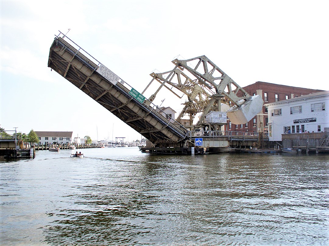
Mystic Bridge Historic District
Monument and historic site · National Register of Historic Places · 0.4 mi
Historic district in Mystic, Connecticut

Mystic River Historic District
Monument and historic site · National Register of Historic Places · 0.9 mi
Historic district in Connecticut, United States

Sabino
Monument and historic site · National Register of Historic Places · 0.7 mi
Wooden, coal-fired steamboat built in 1908
Burnett's Corner
Monument and historic site · National Register of Historic Places · 2.6 mi
Historic district in Connecticut

Capt. Nathaniel B. Palmer House
Monument and historic site · National Register of Historic Places · 2.7 mi
Historic house museum in Stonington, Connecticut, United States
Edward Yeomans House
Monument and historic site · National Register of Historic Places · 2.9 mi
Historic house in Connecticut, United States


Jabez Smith House
Monument and historic site · National Register of Historic Places · 3.8 mi
Historic house in Connecticut, United States
James Merrill House
Monument and historic site · National Register of Historic Places · 3.0 mi
Historic house in Connecticut, United States
John Palmer House
Monument and historic site · National Register of Historic Places · 2.7 mi
Historic house in Lisbon, Connecticut, USA
59 more on the map.
Parks, trails and playgrounds52


Peace Nature Sanctuary
Hiking and trails · 1.1 mi
Private, Open To Public Without Fee; Existing Preserved Open Space
sunrise-sunset

Mystic Aquarium & Institute for Exploration
Park · 1.4 mi
Aquarium in Connecticut
Mystic Ridge Subdivision Open Space
Hiking and trails · 1.5 mi
Municipal, Open To Public Without Fee
Cottrell Marsh
Hiking and trails · 0.9 mi
Both sides of Latimer Point Road, south of railroad tracks. Access onto marsh restricted to protect fragile habitat. Salt marsh and some...
Deans Mill Farm Preserve
Hiking and trails · 1.5 mi
Small White Cedar Swamp, endangered habitat. Long corridor along ledges, above reservoir and into upland woods. Mature, mixed hardwood...
Knox Family Farm Preserve
Hiking and trails · 1.3 mi
Approximately 0.5 miles of trails. Wooded area with kettle hole pond, boulder moraine and frontage on east side of upper Quiambaug Cove....
Knox Preserve
Hiking and trails · 1.3 mi
The Knox Preserve is accessible from Wilcox Road, off Route 1. The ocean-side preserve also abuts the Miner Cemetery – noted as being...
Lambs Way Preserve
Hiking and trails · 0.9 mi
Access from right side of curve at lower end of Lamb’s Way near Quiambaug Fire Station. Open area with view of Fishers Island Sound,...
Mistuxet Hill Preserve (Avalonia Land Conservancy)
Hiking and trails · 0.4 mi
Mistuxet Avenue. Access from Denison Pequotsepos Nature Center trail system. Rocky upland and some wetlands. No formal trails.
40 more on the map.
Restaurants and cafes69


PEARL Provisions + Tipples
Diner · American · 0.8 mi
7 Water Street, Mystic
Th-Su 11:00-21:00; We 16:00-21:00

Starbucks
Cafe · Coffee Shop · 1.3 mi
12 Coogan Boulevard, Stonington
Mo-Fr 04:30-21:00; Sa,Su 05:00-21:00
Via Emilia
Restaurant · Italian · 0.7 mi
24 West Main Street, Mystic
Mo-Th 17:00-21:00; Fr,Sa 15:00-21:30; Su 15:00-20:30

Misfit Club
Bar and pub · 0.8 mi
12 APT #12 Water Street, Mystic
Su,We-Th 16:00-22:00; Fr-Sa 16:00-01:00
57 more on the map.
History
Before the 17th century, the Pequot people lived in this portion of southeastern Connecticut. They were in control of a considerable amount of territory, extending toward the Pawcatuck River to the east and the Connecticut River to the west.
To the northwest, the Five Nations of the Iroquois dominated the land linked by the Great Lakes and the Hudson River, allowing trading to occur between the Iroquois and the Dutch. The Pequots were settled just distant enough to be secure from any danger that the Iroquois posed. The Pequot War profoundly affected the Mystic area between 1636 and 1638. In May 1637, captains John Underhill and John Mason led a mission through Narragansett land, along with their allies the Narragansetts and Mohegans, and struck the Pequot Indian settlement in Mystic in the event which came to be known as the Mystic massacre. On September 21, 1638, the colonists signed the Treaty of Hartford, officially ending the Pequot War.
From the History section of Mystic, Connecticut on Wikipedia, under CC BY-SA 4.0.
Where to stay15
Residence Inn by Marriott Mystic Groton
Motel and hotel · 1.6 mi
40 Whitehall Avenue, Mystic;Stonington
Holiday Inn Express Mystic - Groton
Motel and hotel · 1.2 mi
6 Coogan Boulevard, Stonington
Mystic River Hotel & Suites
Motel and hotel · 1.5 mi
9 Whitehall Avenue, Stonington
Churches and places of worship6
Mystic Congregational Church
Church · United Church Of Christ · 0.4 mi
45 East Main Street, Stonington
First Church of Christ Scientist
Church · Christ Scientist · 0.7 mi
5 Gravel Street, Groton
Shopping38
Gas and EV charging4
Schools, colleges and libraries16
Mystic Seaport Collections Research Center
Library · 0.8 mi
112 Greenmanville Avenue, Stonington;Mystic
Healthcare2
Hartford HealthCare HealthCenter - Mystic
Clinic and pharmacy · 1.4 mi
100 Perkins Farm Drive, Mystic
Map of Mystic
250 places. The map loads OpenStreetMap tiles when you open it.
Climate by month
Monthly table
| Month | High | Low | Rain | Snow |
|---|---|---|---|---|
| Jan | 39°F | 24°F | 3.9 in | 5.8 in |
| Feb | 41°F | 25°F | 3.4 in | 8.3 in |
| Mar | 47°F | 32°F | 4.9 in | 3.9 in |
| Apr | 57°F | 41°F | 4.4 in | 0.8 in |
| May | 66°F | 50°F | 3.7 in | 0.0 in |
| Jun | 75°F | 59°F | 3.9 in | 0.0 in |
| Jul | 81°F | 66°F | 3.4 in | 0.0 in |
| Aug | 80°F | 65°F | 4.2 in | 0.0 in |
| Sep | 74°F | 58°F | 4.3 in | 0.0 in |
| Oct | 63°F | 47°F | 4.4 in | 0.0 in |
| Nov | 53°F | 38°F | 3.8 in | 0.5 in |
| Dec | 44°F | 30°F | 4.6 in | 5.2 in |
U.S. Climate Normals 1991-2020 for Groton Hcn (4 mi away), NOAA NCEI.
People and cost of living
American Community Survey 5-year estimates, 2020-2024, U.S. Census Bureau. Estimates have margins of error, larger for small towns.
Disaster history
The county has had 24 federal disaster declarations since 2000, most often for severe storms.
- 2024-01-13: Severe Storms, Flooding, And A Potential Dam Breach (Severe Storm)
- 2021-10-30: Remnants Of Hurricane Ida (Hurricane)
- 2021-08-22: Hurricane Henri (Hurricane)
- 2021-01-12: Tropical Storm Isaias (Hurricane)
- 2020-08-06: Tropical Storm Isaias (Hurricane)
- 2020-03-28: Covid-19 Pandemic (Biological)
OpenFEMA disaster declarations summaries.
Getting there and nearby towns
Groton-New London Airport (GON) is the nearest airport with scheduled flights listed in OpenStreetMap, 5 miles away.
- Poquonock Bridge 3 mi southwest, about 5 min by car
- Long Hill 5 mi west, about 8 min by car
- Groton 6 mi west, about 10 min by car
- Conning Towers-Nautilus Park 6 mi northwest, about 10 min by car
- New London 7 mi west, about 12 min by car
- Westerly 8 mi east, about 13 min by car
- Gales Ferry 8 mi northwest, about 13 min by car
- Norwich 15 mi northwest, about 24 min by car
- Jewett City 18 mi north, about 28 min by car
- Baltic 19 mi north, about 30 min by car
Drive times are estimates from straight-line distance, not routes.
Local news
Headlines from INDB, the NEMICO news database.
Reviews, tips and questions
Loading what members have shared...
Sources and licences
- NCES EDGE (Public domain): public schools
- NOAA NCEI U.S. Climate Normals 1991-2020 (Public domain): climate by month
- OpenFEMA (Public domain): disaster declarations
- OpenStreetMap contributors (ODbL 1.0): places, airports, map data
- U.S. Census Bureau (Public domain): population, income, housing, education, commute
- Wikidata (CC0 1.0): elevation, founding date, time zone, website, landmarks and historic places
- Wikimedia Commons (see each image): photos
- Wikipedia (CC BY-SA 4.0): overview and history text
Photo credits
- US 1 in Mystic, Connecticut, Juliancolton, Public domain
- Mystic River 02, Ad Meskens, CC BY-SA 3.0
- Mystic River 03, Ad Meskens, CC BY-SA 3.0
- Mystic River, Ad Meskens, CC BY-SA 3.0
- Mystic River 04, Ad Meskens, CC BY-SA 3.0
- Mystic Denison Burying Ground 03, Ad Meskens, CC BY-SA 3.0
- Mystic Denison Burying Ground, Ad Meskens, CC BY-SA 3.0
- Parrot Cannon Denison Mystic, Ad Meskens, CC BY-SA 3.0
- Mystic Denison Burying Ground 02, Ad Meskens, CC BY-SA 3.0
- Mystic water tower, Ad Meskens, CC BY-SA 3.0
- Mystic water tower 02, Ad Meskens, CC BY-SA 3.0
- Mystic train depot, Connecticut, Kenneth C. Zirkel, CC BY-SA 4.0
- Mystic station facing southeast, August 2012, Pi.1415926535, CC BY-SA 3.0
- Mystic station facing south, August 2012, Pi.1415926535, CC BY-SA 3.0
- Mystic Soldiers' Monument 01, Ad Meskens, CC BY-SA 3.0
- Mystic Soldiers' Monument 04, Ad Meskens, CC BY-SA 3.0
- Mystic Congregational Church 03, Ad Meskens, CC BY-SA 3.0
- Mystic Congregational Church and Civil War Monument 02, Ad Meskens, CC BY-SA 3.0
- Mystic Congregational Church and Civil War Monument 03, Ad Meskens, CC BY-SA 3.0
- Mystic Congregational Church, Ad Meskens, CC BY-SA 3.0
- Mystic Soldiers' Monument 03, Ad Meskens, CC BY-SA 3.0
- Mystic Soldiers' Monument 06, Ad Meskens, CC BY-SA 3.0
- Mystic Soldiers' Monument 05, Ad Meskens, CC BY-SA 3.0
- Mystic Congregational Church and Civil War Monument, Ad Meskens, CC BY-SA 3.0
- Mystic Congregational Church 02, Ad Meskens, CC BY-SA 3.0
- Mystic Soldiers' Monument 02, Ad Meskens, CC BY-SA 3.0
- Mystic Amtrak HDR, Mirza Ahmed, CC BY-SA 4.0
- Mystic station facing northwest, August 2012, Pi.1415926535, CC BY-SA 3.0
- Mystic Amtrak tracks, Mirza Ahmed, CC BY-SA 4.0
- Mystic Amtrak HDR-PANO, Mirza Ahmed, CC BY-SA 4.0
- Mystic station from parking lot, December 2017, Pi.1415926535, CC BY-SA 3.0
- MysticTown, Monsieur dl mon talk - mon contribs, Public domain
- EmmaberrymysticCTUSA, Staib, CC BY 3.0
- Sabino Mystic Oct 2020, Godsfriendchuck, CC BY-SA 4.0
- Mystic River Bridge, Rhvanwinkle ( talk ), CC BY 3.0
- Jabez Smith House, Groton, CT, Pi.1415926535, CC BY-SA 3.0
- Pequotseposmanor-mystic-ct-usa, Staib, CC BY 3.0
- Palmer House 2013, Ɱ, CC BY-SA 3.0
- Stonington Cemeterey Connecticut, Logatorial and The Stonington Cemetery Association ([email protected]), CC BY-SA 4.0
- WHITEHALL MANSION, NEW LONDON COUNTY, Jerrye & Roy Klotz, MD, CC BY-SA 4.0


Page built October 30, 2026. Spotted a mistake? Tell us or suggest a place.