


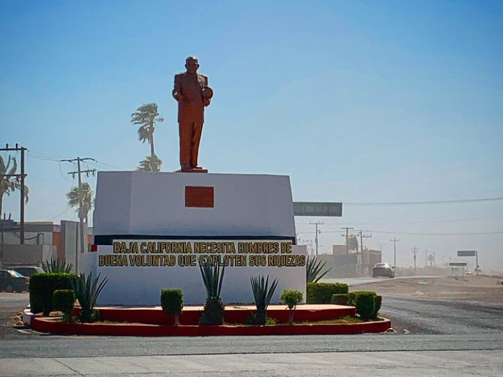

Ciudad Constitución, Mexico
Ciudad Constitución is a town of 40,935 people in Baja California Sur, Mexico, founded in 1953.
Why visit Ciudad Constitución
Townapedia lists 2 museums and landmarks, 29 parks and trails, 6 places to eat and 3 places to stay in and around town.
Highlights include Camellón Cervantes de río and Camellón Cervantes de río.
Weather in Ciudad Constitución
Forecast from MET Norway (CC BY 4.0). Full forecast
About Ciudad Constitución
Ciudad Constitución is a city in the Mexican state of Baja California Sur. It is the seat of the municipality of Comondú. As of 2020, the city had a total population of 43,805 inhabitants. Ciudad Constitución is a small city which serves as a gateway to Magdalena Bay.
From the Wikipedia article Ciudad Constitución (this version), under CC BY-SA 4.0.
Travel tips from other travellers: Ciudad Constitución on Wikivoyage (CC BY-SA 4.0).
Museums and landmarks2


Parks, trails and playgrounds29

17 more on the map.
Restaurants and cafes6

Parlante Restaurant " ... El Lugar"
Restaurant · Coffee Shop, Mexican, Sandwich · 1.2 km
Th-Tu 08:00-17:00


Where to stay3

Hotel Maribel
Motel and hotel · 1.4 km
156 Calle Guadalupe Victoria, Cuidad Constitución
History
The colonization of Valle de Santo Domingo (Valley of Santo Domingo) originated around 1940. A ranch called El Crucero ("The Crossroad") was settled in a crossroad. Because of this, people started to gather around it and the population started to grow. It quickly became a commercial hub and an obligatory travel stop for all the inhabitants of Valle de Santo Domingo, as well as for people going north or south on the peninsula. Then, it became known as Villa Constitución, and later, Ciudad Constitución. Even today, many locals still call it "El Crucero". Every 5 February the city becomes the state's capital for one day. Since 1996, the Instituto Tecnológico Superior de Ciudad Constitución serves as a higher education institution.
From the History section of Ciudad Constitución on Wikipedia, under CC BY-SA 4.0.
Shopping5
Bodega Aurrera
Grocery · 1.6 km
450 Blvd. Agustin Olachea Aviles Norte 450, Cuidad Constitución
Gas and EV charging1
Schools, colleges and libraries3
Healthcare1
Map of Ciudad Constitución
50 places. The map loads OpenStreetMap tiles when you open it.
Getting there and nearby towns
Ciudad Constitución Airport (CUA) is the nearest airport with scheduled flights listed in OpenStreetMap, 5 km away.
- Villa Morelos 12 km south, about 12 min by car
- Benito Juárez 19 km northwest, about 19 min by car
- Ciudad Insurgentes 28 km northwest, about 28 min by car
- Ley Federal de Aguas Número Uno 34 km north, about 34 min by car
- Puerto Adolfo López Mateos 48 km west, about 48 min by car
- Puerto San Carlos 52 km southwest, about 52 min by car
- Valle Santo Domingo 57 km northwest, about 57 min by car
Drive times are estimates from straight-line distance, not routes.
Local news
Headlines from INDB.
Reviews, tips and questions
Loading what members have shared...
Sources and licences
- GeoNames (CC BY 4.0): population, coordinates, regions and time zone
- OpenStreetMap contributors (ODbL 1.0): places, airports, map data
- Wikidata (CC0 1.0): elevation, founding date, time zone, website
- Wikimedia Commons (see each image): photos
- Wikipedia (CC BY-SA 4.0): overview and history text
Photo credits
- Un atardecer en el valle(B.C.S), Selena Cortes, CC BY-SA 4.0
- Presidencia municipal de Comondú, José González Peña, CC BY-SA 4.0
- Monumento con la nombre El Valle Comondú, José González Peña, CC BY-SA 4.0
- Monumento del general Agustin Olachea, José González Peña, CC BY-SA 4.0
Page built November 4, 2026. Spotted a mistake? Tell us or suggest a place.