


Ciudad Juárez, Mexico
Ciudad Juárez is a town of 1,512,450 people in Chihuahua, Mexico, founded in 1659.
Why visit Ciudad Juárez
Townapedia lists 103 museums and landmarks, 53 parks and trails, 127 places to eat, 25 places to stay and 25 attractions in and around town.
Highlights include Autonomous University of Ciudad Juárez, Bridge of the Americas, Abdou Building and Alhambra Theatre.
Weather in Ciudad Juárez
Forecast from MET Norway (CC BY 4.0). Full forecast
About Ciudad Juárez
Ciudad Juárez (US: sew-DAHD HWAR-ez; Spanish: [sjuˈðað ˈxwaɾes] ; "Juárez City"), commonly referred to as just Juárez (Lipan: Tsé Táhú'ayá), is the most populous city in the Mexican state of Chihuahua. It was known until 1888 as El Paso del Norte ("The North Pass").
From the Wikipedia article Ciudad Juárez (this version), under CC BY-SA 4.0.
Travel tips from other travellers: Ciudad Juárez on Wikivoyage (CC BY-SA 4.0).
Things to do25

Autonomous University of Ciudad Juárez
School · 2.8 km
University in Chihuahua, Mexico

Bridge of the Americas
Bridge · 5.0 km
Bridge connecting the Mexican state of Chihuahua with the U.S. state of Texas

Chavez Theatre
Cinema and theater · 5.0 km
Concert hall in El Paso, Texas

Paso del Norte International Bridge
Bridge · 3.9 km
Bridge between Mexico and the United States

Stanton Street Bridge
Bridge · 3.7 km
International bridge between El Paso, Texas, United States and Ciudad Juárez, Chihuahua, Mexico
Texas Tech University Health Sciences Center El Paso
School · 6.3 km
Health sciences university in El Paso, Texas, United States

Western Playland
Monument and historic site · 13.1 km
Amusement park in Sunland Park, New Mexico, United States

13 more on the map.
Museums and landmarks103

Abdou Building
Monument and historic site · National Register of Historic Places · 4.9 km
Building in El Paso, El Paso County, Texas

Alhambra Theatre
Cinema and theater · National Register of Historic Places · 4.9 km
Theatre in El Paso, Texas, United States
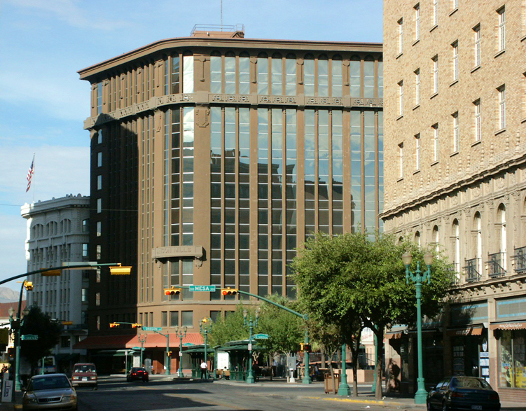
Anson Mills Building
Monument and historic site · National Register of Historic Places · 5.1 km
Building in El Paso (vicinity), El Paso County, Texas

Blue Flame Building
Monument and historic site · National Register of Historic Places · 5.0 km
Building in El Paso (vicinity), El Paso County, Texas

Chamizal National Memorial
Monument and historic site · National Register of Historic Places · 5.3 km
Historic district in El Paso, El Paso County, Texas

El Paso High School
Monument and historic site · National Register of Historic Places · 6.5 km
Historic place in El Paso, El Paso County, Texas

First Mortgage Company Building
Monument and historic site · National Register of Historic Places · 4.9 km
Building in El Paso, El Paso County, Texas

Fort Bliss Main Post Historic District
Monument and historic site · National Register of Historic Places · 10.0 km
Historic district in El Paso, El Paso County, Texas

Fort Bliss National Cemetery
Monument and historic site · National Register of Historic Places · 12.0 km
U.S. national cemetery in El Paso, Texas

Franklin Canal
Monument and historic site · National Register of Historic Places · 9.6 km
Structure in El Paso (vicinity), El Paso County, Texas

Henry C. Trost House
Monument and historic site · National Register of Historic Places · 6.2 km
Building in El Paso, El Paso County, Texas

Hotel Cortez
Monument and historic site · National Register of Historic Places · 5.1 km
Historic place in El Paso, El Paso County, Texas
91 more on the map.
Parks, trails and playgrounds53




San Jacinto Plaza
Park · 5.1 km
Park in El Paso, Texas surrounded by Main, Mills, Oregon, and Mesa streets

41 more on the map.
Restaurants and cafes127

Hungry Brothers
Restaurant · 3.1 km
Hungry Brothers es un rincón gastronómico que te hará salir chupándote los dedos! Sandwiches, Hamburguesas, Ensaladas, Postres y Más!
6372 Avenida de la Raza
Mo-Th 07:30-23:00; Fr, Sa 07:30-01:30; Su 08:00-20:00

Los Girasoles
Restaurant · Regional, Mexican · 1.6 km
4995 Cedros, Ciudad Juarez
Mo-Fr 09:00-16:30, Su 08:00-13:30
alisson diner
Restaurant · Seafood, Sushi, Burger, European · 1.6 km
567 Calle Navarra, juarez
Mo-Fr 08:00-17:00
Red Panda
Restaurant · Japanese · 4.5 km
7244 Avenida Ejército Nacional

115 more on the map.
History
As 17th-century Spanish explorers sought a route through the southern Rocky Mountains, the Franciscan Friar García de San Francisco founded Ciudad Juárez in 1659 as "El Paso del Norte" ("The North Pass"). The Misión de Guadalupe de los Mansos en el Paso del río del Norte became the first permanent Spanish development in the area in the 1660s. The Franciscan friars established a community that grew in importance as commerce between Santa Fe and Chihuahua passed through it. The wood for the first bridge across the Rio Grande came from Santa Fe, New Mexico, in the late 18th century. The original population of Mansos, Suma, Jumano, and other natives from the south brought by the Spanish from Central New Spain grew around the mission. In 1680 during the Pueblo Revolt, most of the Piro Pueblo and some of the Tiwa people branch of the Pueblo became refugees. A mission was established for the Tigua in Ysleta del Sur. Piro Pueblo colonial era settlements along El Camino Real, south of the Guadalupe Mission, included missions Real de San Lorenzo, Senecú del Sur, and Soccoro del Sur. Presidio del Nuestra Señora del Pilar del Paso del Rio Norte was established near the mission in 1683.
From the History section of Ciudad Juárez on Wikipedia, under CC BY-SA 4.0.
Where to stay25
Churches and places of worship68
Socorro Mission
Church · National Register of Historic Places · 16.5 km
Oratorio Santo Domingo Savio;Santo Domingo Savio
Church · Catholic · 3.5 km
4323;4326 Calle Fidel Ávila
Shopping71
Bicicletas El Pedal
Shop · 2.0 km
2689 Boulevard Licenciado Oscar Flores Sánchez, Juárez
Bicicletas Estralla Roja
Shop · 2.0 km
2715 Boulevard Licenciado Oscar Flores Sánchez
Gas and EV charging62
Schools, colleges and libraries69
Seminario Conciliar de Ciudad Juárez
School · Catholic · 4.5 km
7860 Avenida Pedro Rosales de León
Centro de Actualizacion del Magisterio de Ciudad Juárez
School · 2.4 km
5539 Benemérito de las Américas, Ciudad Juarez
Healthcare27
Map of Ciudad Juárez
250 places. The map loads OpenStreetMap tiles when you open it.
Getting there and nearby towns
Abraham González International Airport (CJS) is the nearest airport with scheduled flights listed in OpenStreetMap, 10 km away.
- El Paso 14 km north, about 14 min by car
- Fort Bliss 16 km northeast, about 16 min by car
- Sunland Park 17 km northwest, about 17 min by car
- Socorro 21 km southeast, about 21 min by car
- San Elizario 25 km southeast, about 25 min by car
- Horizon City 26 km east, about 26 min by car
- Canutillo 26 km northwest, about 26 min by car
- Santa Teresa 26 km northwest, about 26 min by car
- Clint 26 km southeast, about 26 min by car
- Homestead Meadows South 30 km east, about 30 min by car
Drive times are estimates from straight-line distance, not routes.
Local news
Headlines from INDB.
Reviews, tips and questions
Loading what members have shared...
Sources and licences
- GeoNames (CC BY 4.0): population, coordinates, regions and time zone
- OpenStreetMap contributors (ODbL 1.0): places, airports, map data
- Wikidata (CC0 1.0): elevation, founding date, time zone, website, landmarks and historic places
- Wikimedia Commons (see each image): photos
- Wikipedia (CC BY-SA 4.0): overview and history text
Photo credits
- Juarez montage, Hachiroo, CC BY-SA 3.0
- Ciudad Juárez Skyline (Paseo Triunfo), Rosalesmx, CC BY-SA 4.0
- Cruze en Ciudad Juárez. - panoramio, Wiper México, CC BY-SA 3.0
- Museo de la Revolución en la Frontera, Ciudad Juárez 10, Wotancito, CC BY-SA 4.0
- Museo de la Revolución en la Frontera, Ciudad Juárez 38, Wotancito, CC BY-SA 4.0
- Museo de la Revolución en la Frontera, Ciudad Juárez 08, Wotancito, CC BY-SA 4.0
- Museo de la Revolución en la Frontera, Ciudad Juárez 29, Wotancito, CC BY-SA 4.0
- Museo de la Revolución en la Frontera, Ciudad Juárez 34, Wotancito, CC BY-SA 4.0
- Museo de la Revolución en la Frontera, Ciudad Juárez 04, Wotancito, CC BY-SA 4.0
- Museo de la Revolución en la Frontera, Ciudad Juárez 18, Wotancito, CC BY-SA 4.0
- Museo de la Revolución en la Frontera, Ciudad Juárez 28, Wotancito, CC BY-SA 4.0
- Museo de la Revolución en la Frontera, Ciudad Juárez 03, Wotancito, CC BY-SA 4.0
- Museo de la Revolución en la Frontera, Ciudad Juárez 25, Wotancito, CC BY-SA 4.0
- Museo de la Revolución en la Frontera, Ciudad Juárez 44, Wotancito, CC BY-SA 4.0
- Museo de la Revolución en la Frontera, Ciudad Juárez 22, Wotancito, CC BY-SA 4.0
- Museo de la Revolución en la Frontera, Ciudad Juárez 33, Wotancito, CC BY-SA 4.0
- Museo de la Revolución en la Frontera, Ciudad Juárez 31, Wotancito, CC BY-SA 4.0
- Museo de la Revolución en la Frontera, Ciudad Juárez 23, Wotancito, CC BY-SA 4.0
- Museo de la Revolución en la Frontera, Ciudad Juárez 17, Wotancito, CC BY-SA 4.0
- Museo de la Revolución en la Frontera, Ciudad Juárez 16, Wotancito, CC BY-SA 4.0
- Museo de la Revolución en la Frontera, Ciudad Juárez 06, Wotancito, CC BY-SA 4.0
- Museo de la Revolución en la Frontera, Ciudad Juárez 43, Wotancito, CC BY-SA 4.0
- Museo de la Revolución en la Frontera, Ciudad Juárez 32, Wotancito, CC BY-SA 4.0
- Museo de la Revolución en la Frontera, Ciudad Juárez 35, Wotancito, CC BY-SA 4.0
- Museo de la Revolución en la Frontera, Ciudad Juárez 30, Wotancito, CC BY-SA 4.0
- Museo de la Revolución en la Frontera, Ciudad Juárez 11, Wotancito, CC BY-SA 4.0
- Museo de la Revolución en la Frontera, Ciudad Juárez 01, Wotancito, CC BY-SA 4.0
- Museo de la Revolución en la Frontera, Ciudad Juárez 07, Wotancito, CC BY-SA 4.0
- Museo de la Revolución en la Frontera, Ciudad Juárez 27, Wotancito, CC BY-SA 4.0
- Bridge of the Americas (El Paso–Ciudad Juárez), June 2016, U.S. Customs and Border Protection, Public domain
- Paso Del Norte POE El Paso Texas (27794618513), U.S. Customs and Border Protection, Public domain
- Wester Playland, Dimples915, CC BY-SA 3.0
- Abdou Building, El Paso, TX 2022-05-29, Xnatedawgx, CC BY-SA 4.0
- Alhambra Palace Theater, El Paso, Texas, Unknown author Unknown author, Public domain
- Anson Mills Building, Camerafiend at English Wikipedia, CC BY-SA 3.0
- Blue Flame Building in El Paso as seen from La Placita, Susan Barnum, CC BY-SA 4.0
- Chamizal visitor center, Original uploader was Mosamiazaz at en.wikipedia, Public domain
- El PasoHighSchool, Bobbobbb, Public domain
- Fort Bliss Main Post Historic District 2012-09-02 13-44-45, knaverob, CC BY-SA 3.0
- Soldiers Honor Their Own DVIDS22242, Spc. Creighton Holub, Public domain
- The Trost House 04, Rogelio Rivero Cagigas, CC BY-SA 3.0
- Hotel Cortez, 303 N. Mesa St. El Paso, Rogelio Rivero Cagigas, CC BY-SA 3.0
- The Plaza, El Paso, Texas, Detroit Publishing Co., Public domain
- Cathedral Parish of St Pat, El Paso, Lyricmac at English Wikipedia, CC BY 2.5
- Ciudad Juarez Temple by Christine Asay, Christine Asay, CC BY-SA 3.0
- Juarez Cathedrale et mission 24-02-2007, François Hirsch, Public domain
- Zoo exit, Dimples915, CC BY-SA 3.0
- El Paso Stanton Street Port of Entry, Wbaron, CC BY-SA 3.0
- First Mortgage Company Building El PasoTX02, Rogelio Rivero Cagigas, CC BY-SA 3.0


Page built November 4, 2026. Spotted a mistake? Tell us or suggest a place.