
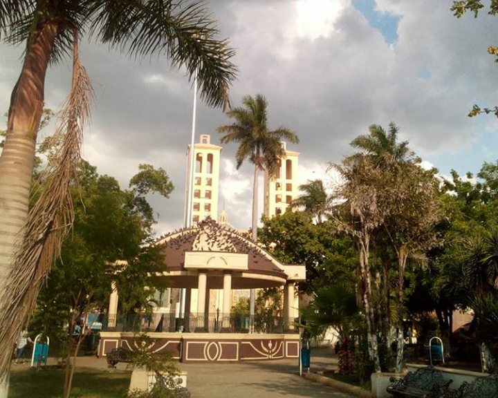


Ciudad Mante, Mexico
Ciudad Mante is a town of 84,787 people in Tamaulipas, Mexico, founded in March 8, 1764.
Why visit Ciudad Mante
Townapedia lists 19 parks and trails, 10 places to eat, 2 places to stay and 2 attractions in and around town.
Weather in Ciudad Mante
Forecast from MET Norway (CC BY 4.0). Full forecast
About Ciudad Mante
Mante, formally Ciudad Mante, is a city in the Mexican state of Tamaulipas. The city is the municipal seat of El Mante municipality in extreme southern Tamaulipas, and lies in the northwestern portion of the municipality. It had a 2005 census population of 81,884 inhabitants, or about 73 percent of El Mante's total of 112,061. The city is the state's ninth-largest community in population.
From the Wikipedia article Ciudad Mante (this version), under CC BY-SA 4.0.
Things to do2

Parks, trails and playgrounds19


7 more on the map.
Restaurants and cafes10




Where to stay2

History
The region known today as Mante is taken from the Huastecan Indian name, "cinco potreros de Tamatán", or the five pasture grounds, and in the "Tenek" or Huastecan language a word that means, "the embarkation of canoes."
According to various documents, it was a very unsanitary place due to the flooding that the land suffered when the regional rivers overflowed, and more so due to the Mante River whose waters stagnated for months without any exit causing caused the formation of large lime deposits that afterwards became a breeding ground for mosquitos and horse-flies whose sting was very painful. Due to these insupportable and unsanitary conditions the Spanish could not colonize the region permanently, although due to the rich and fertile capability of the ground they did farm the area.
According to several studies there were several Indian tribes of "collectors-hunters" that inhabited the area with the Parnes, Chichimecas and Janambres as the predominant tribes in the area. The Janambres represented a formidable danger to those who attempted colonization as they attacked all who tried to settle in the "Tamatán" area. There are many stories that the Janambres were constantly hostile towards the colonists and when these fought to repel the attacks, the Indians withdrew to the hills.
From the History section of Ciudad Mante on Wikipedia, under CC BY-SA 4.0.
Churches and places of worship3
Shopping3
Schools, colleges and libraries8
Healthcare6
Map of Ciudad Mante
53 places. The map loads OpenStreetMap tiles when you open it.
Getting there and nearby towns
Aeródromo Las Huastecas (MMC) is the nearest airport with scheduled flights listed in OpenStreetMap, 5 km away.
- Emiliano Zapata 6 km southeast, about 6 min by car
- El Limón 10 km north, about 10 min by car
- Mártires de Río Blanco 10 km north, about 10 min by car
- Quintero 11 km southwest, about 11 min by car
- El Abra 14 km south, about 14 min by car
- Praxedis Guerrero 17 km southwest, about 17 min by car
- Celaya 21 km south, about 21 min by car
- Antiguo Morelos 24 km southwest, about 24 min by car
- Primero de Mayo 24 km north, about 24 min by car
- Ciudad Valles 83 km south, about 1 h 30 min by car
Drive times are estimates from straight-line distance, not routes.
Local news
Headlines from INDB.
Reviews, tips and questions
Loading what members have shared...
Sources and licences
- GeoNames (CC BY 4.0): population, coordinates, regions and time zone
- OpenStreetMap contributors (ODbL 1.0): places, airports, map data
- Wikidata (CC0 1.0): elevation, founding date, time zone, website
- Wikimedia Commons (see each image): photos
- Wikipedia (CC BY-SA 4.0): overview and history text
Photo credits
- Centro en Ciudad Mante, Tamaulipas, noblem8, CC BY 4.0
- CBTis 15, Ciudad Mante - panoramio, Infernalist, CC BY 3.0
Page built November 4, 2026. Spotted a mistake? Tell us or suggest a place.