
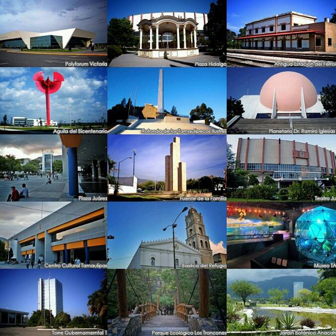


Ciudad Victoria, Mexico
Ciudad Victoria is a regional capital of 332,100 people in Tamaulipas, Mexico, founded in October 6, 1750.
Why visit Ciudad Victoria
Townapedia lists 11 museums and landmarks, 57 parks and trails, 60 places to eat, 18 places to stay and 11 attractions in and around town.
Highlights include Autonomous University of Tamaulipas, Monumental Flag and Estadio Marte Rodolfo Gómez Segura.
Weather in Ciudad Victoria
Forecast from MET Norway (CC BY 4.0). Full forecast
About Ciudad Victoria
Ciudad Victoria (Spanish pronunciation: [sjuˈðað biɣˈtoɾja] ) (English: Victoria City) is the capital city of the Mexican state of Tamaulipas and the seat of the Municipality of Victoria. It is located in the northeast of Mexico at the foot of the Sierra Madre Oriental. It borders the municipality of Güémez to the north, Llera to the south, Casas Municipality to the east, and the municipality of Jaumave to the west. The city is located 246 km (153 mi) from Monterrey and 319 km (198 mi) from the US - Mexico border.
From the Wikipedia article Ciudad Victoria (this version), under CC BY-SA 4.0.
Travel tips from other travellers: Ciudad Victoria on Wikivoyage (CC BY-SA 4.0).
Things to do11

Autonomous University of Tamaulipas
School · 0.9 km
Mexican public university based in Victoria, Tamaulipas


Museums and landmarks11





Placa conmemorativa de los Tamaulipecos de la 2a Guerra Mundial
Monument and historic site · 0.8 km
Salón de la Fama de los Deportistas Tamaulipecos
Monument and historic site · 0.8 km
Parks, trails and playgrounds57


Estadio Marte Rodolfo Gómez Segura
Sports field and stadium · 0.9 km


Estadio de basquetbol Raga
Sports field and stadium · 1.0 km
Mier y Teran, Ciudad Victoria
Estadio Universitario Prof. Eugenio Alvizo Porras
Sports field and stadium · 2.6 km
Justo Sierra, Victoria

Parque Estatal El Refugio
Hiking and trails · 2.7 km
Parque Estatal El Refugio, con variedad de especies animales y vegetacion
45 more on the map.
Restaurants and cafes60


Café Limón
Cafe · Coffee Shop, Pastry · 1.3 km
217 Calle Gaspar de la Garza, Cd. Victoria
Mo-Fr 09:00-16:00
Dharma Veggie Coffee
Restaurant · 1.2 km
244 Francisco I. Madero (Calle 17)
Mo-Su 11:00-22:00
Taco Paraíso
Restaurant · Mexican, Tacos · 2.5 km
3262 Boulevard Tamaulipas, Victoria

48 more on the map.
History
Villa de Santa María de Aguayo was named after the wife of the first Count of Revillagigedo Don Juan Francisco de Güémez y Horcasitas, named Doña Antonia Cepherina Pacheco de Padilla, a native of Aguayo, Province of Santander, Spain.
The settlement was founded by José de Escandon and Helguera, Count of Sierra Gorda, during his second campaign of the Pacification and Colonization Plan of the coast of the Mexican Seno, later called New Santander, today Tamaulipas. The Spanish settlement open to the plain to the East and surrounded to the west by the Sierra Madre Oriental, a strategic location that also received breezes from the north and east. The town was administered by Captain D. Juan de Astigárraga, who drew up and carried out the first irrigation works. His work led to an increase in agriculture and, subsequently, a rapid rise in population.
In religious matters, the settlement was under the command of a Franciscan named Antonio Javier de Aréchaga, who was also in charge of the mission of San Felipe, which was founded with 150 indigenous people. That Catholic mission progressed more than those previously founded, because in the lands that were designated, they were opened by local Native Americans.
From the History section of Ciudad Victoria on Wikipedia, under CC BY-SA 4.0.
Where to stay18
Churches and places of worship6
Shopping31
Gas and EV charging23
Schools, colleges and libraries41
Escuela Secundaria General No. 1 "Pte. Adolfo Ruiz Cortínez"
School · 2.6 km
Calzada General Luis Caballero
Escuela Secundaria General #2 "Prof. Arquimedes Caballero Caballero"
School · 1.9 km
644 Yucatan
Healthcare25
Map of Ciudad Victoria
250 places. The map loads OpenStreetMap tiles when you open it.
Getting there and nearby towns
General Pedro J. Méndez International Airport (CVM) is the nearest airport with scheduled flights listed in OpenStreetMap, 19 km away.
- Benito Juárez 5 km north, about 5 min by car
- La Presa 7 km north, about 7 min by car
- La Libertad 7 km northwest, about 7 min by car
- La Misión 7 km north, about 7 min by car
- El Olmo (Rancho Nuevo del Castillo) 7 km southeast, about 7 min by car
- Aquiles Serdán 9 km north, about 9 min by car
- Congregación Caballeros 14 km north, about 14 min by car
- Manuel Ávila Camacho 17 km southeast, about 17 min by car
- San José de las Flores 18 km north, about 18 min by car
- San Cayetano 19 km north, about 19 min by car
Drive times are estimates from straight-line distance, not routes.
Local news
Headlines from INDB.
Reviews, tips and questions
Loading what members have shared...
Sources and licences
- GeoNames (CC BY 4.0): population, coordinates, regions and time zone
- OpenStreetMap contributors (ODbL 1.0): places, airports, map data
- Wikidata (CC0 1.0): elevation, founding date, time zone, website, landmarks and historic places
- Wikimedia Commons (see each image): photos
- Wikipedia (CC BY-SA 4.0): overview and history text
Photo credits
- Montaje de Victoria, Calixto8910, CC BY-SA 3.0
- Catedral Ciudad Victoria, Sagrado Corazón de Jesús, Ciudad Victoria, Estado de Tamaulipas, México (10634382494), Catedrales e Iglesias/Cathedrals and Churches from Ciudad de México, Mexico, CC BY 2.0
- Club correcaminos, Jose ismael mv, CC BY-SA 3.0
- Bandera Monumental Ensenada, José R. Quintanilla, CC BY 2.5
- Siglas-UAT, Universidad, CC BY-SA 4.0
- Izando la bandera monumental del zocalo, gib_l, CC BY-SA 2.0
- Cuerudo tamaulipeco - panoramio, panza.rayada, CC BY-SA 3.0
- Jardín polinizador del Museo Regional de Historia de Tamaulipas (MRHT), Castañedatamaulipas, CC BY-SA 4.0
Page built November 4, 2026. Spotted a mistake? Tell us or suggest a place.