
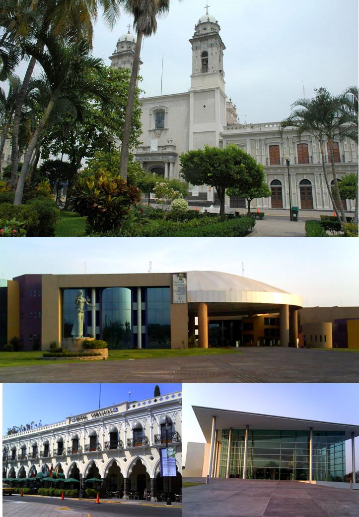


Colima, Mexico
Colima is a regional capital of 146,965 people in Colima, Mexico, founded in January 30, 1527.
Why visit Colima
Townapedia lists 39 museums and landmarks, 70 parks and trails, 134 places to eat, 14 places to stay and 24 attractions in and around town.
Highlights include University of Colima, Museo de Ciencia y Tecnología Xoloitzcuintle and Capacha.
Weather in Colima
Forecast from MET Norway (CC BY 4.0). Full forecast
About Colima
Colima (Spanish pronunciation: [koˈlima]), located in west−central Mexico, is the capital of the state of the same name and the seat of the municipality of the same name. It is the easternmost and second-largest municipality of Colima, behind Manzanillo. It is located near the Colima volcano, which divides the state from Jalisco. The city of Colima is part of the Colima metropolitan area which also includes Villa de Álvarez and other municipalities.
From the Wikipedia article Colima (city) (this version), under CC BY-SA 4.0.
Travel tips from other travellers: Colima on Wikivoyage (CC BY-SA 4.0).
Things to do24
University of Colima
School · 1.5 km
University and open-access publisher

Antiguo Cine Reforma
Cinema and theater · 2.4 km
Antiguo cine, actualmente el edificio se encuentra sin operar y en malas condiciones
373 Gral Manuel Alvarez, Villa de Álvarez
12 more on the map.
Museums and landmarks39

Museo de Ciencia y Tecnología Xoloitzcuintle
Museum · 0.6 km
Calzada General Pedro A. Galván Norte, Colima
Tu-Fr 10:00-13:30, 16:00-18:00, Sa-Su 14:00-18:00

Capacha
Monument and historic site · 4.7 km
Archaeological site in Colima State, Mexico

El Chanal
Monument and historic site · 5.4 km
Archaeological site located at El Chanal town, Mexico


Museo Universitario de Artes Populares María Teresa Pomar
Museum · 1.1 km
Museo de Arte Popular
27 more on the map.
Parks, trails and playgrounds70



58 more on the map.
Restaurants and cafes134

MeLT Pizza
Restaurant · Pizza · 2.6 km
Las originales Deep Dish Pizza de Chicago con la receta original y un pequeño toque mexicano.
2132 Constitución, Colima
Mo-Sa 18:00-24:00; Su 15:00-23:00
Restaurante Italiano Bel Paese
Restaurant · Italian · 1.3 km
Restaurant italien
851 Av. Constitución, Colima
Tu-Su 14:00-23:00
Todos Santos
Restaurant · Seafood, Taco · 2.3 km
Antojitos del mar: Tacos, Quesadillas, Tostadas de mariscos, camarón, atún, marlin, pescado y jaiba.
2035-5 Constitución, Colima
Tu-Su 11:30-18:00
Asadero Don José
Restaurant · Mexican, Grill · 0.7 km
574 Felipe Sevilla del Rio, Colima
Mo-Sa 14:00-23:30; Su 13:00-19:00

Boston Bar
Bar and pub · Pizza, Burguer, Wings · 1.3 km
900-C Avenida Constitución, Colima
We-Sa 19:00-2:00

Chepe Parrilla de Barrio
Restaurant · Grill, Tacos · 2.5 km
122 Avenida La Paz, Colima
Mo-Th 14:00-22:30, Fr-Sa 14:00-23:30, Su 14:00-17:00
122 more on the map.
Where to stay14
Churches and places of worship28
Rectoría de San Rafael Arcángel
Church · Roman Catholic · 1.5 km
701 Venustiano Carranza, Colima
Grupo Amor de México AR
Church · Cristiana · 2.5 km
307 Gral Manuel Alvarez, Colima
Iglesia Cristo la Roca
Church · Baptist · 1.9 km
1407 Calle Ignacio López Rayón, Colima
Rectoría de Espíritu Santo
Church · Roman Catholic · 0.9 km
Avenida Felipe Sevilla del Río, Colima
Sagrario de San Felipe de Jesús
Church · Roman Catholic · 1.5 km
70 Calle Constitución, Colima
Shopping30
Gas and EV charging13
Schools, colleges and libraries178
Healthcare30
Farmacia de Genéricos
Clinic and pharmacy · 2.7 km
245 Gral Manuel Alvarez, Colima
Map of Colima
250 places. The map loads OpenStreetMap tiles when you open it.
Getting there and nearby towns
Lic. Miguel de la Madrid Airport (CLQ) is the nearest airport with scheduled flights listed in OpenStreetMap, 14 km away.
- Ciudad de Villa de Álvarez 4 km northwest, about 4 min by car
- El Chanal 6 km north, about 6 min by car
- El Trapiche 6 km northeast, about 6 min by car
- Comala 10 km northwest, about 10 min by car
- Piscila 10 km south, about 10 min by car
- Coquimatlán 11 km southwest, about 11 min by car
- Buenavista 11 km east, about 11 min by car
- Chiapa 12 km northeast, about 12 min by car
- Ocotillo 12 km northeast, about 12 min by car
- Manzanillo 68 km west, about 1 h 15 min by car
Drive times are estimates from straight-line distance, not routes.
Local news
Headlines from INDB.
Reviews, tips and questions
Loading what members have shared...
Sources and licences
- GeoNames (CC BY 4.0): population, coordinates, regions and time zone
- OpenStreetMap contributors (ODbL 1.0): places, airports, map data
- Wikidata (CC0 1.0): elevation, founding date, time zone, website, landmarks and historic places
- Wikimedia Commons (see each image): photos
- Wikipedia (CC BY-SA 4.0): overview and history text
Photo credits
- Colima Colima collage, Basílica_Menor_de_Colima.jpg : wonderlane Complejo_Administrativo_Colima.png : Elzodiacogriego Hotel_Ceballos_Colima.png : Elzodiacogriego Colima_University_Hall.png : Elzodiacogriego derivative..., CC BY-SA 3.0
- Faculty of Law University of Colima, Elzodiacogriego, CC BY-SA 3.0
- Museo Maria Teresa Pomar, Yaomautzin Ohtokani Olvera Lara, CC BY-SA 4.0
- Catedral de Colima, Salvador alc, CC BY-SA 3.0
- Zona Arqueológica de El Chanal en Colima, México (15-01-2003), Yaomautzin Ohtokani Olvera Lara, CC BY-SA 3.0
- Pinacoteca Alfonso Michel, Yaomautzin Ohtokani Olvera Lara, CC BY-SA 3.0
Page built November 4, 2026. Spotted a mistake? Tell us or suggest a place.